What Is SLAM? How Simultaneous Localization and Mapping Works for Drones
BY Zacc Dukowitz
8 July 2026SLAM (simultaneous localization and mapping) lets drones and other autonomous vehicles build a map of their surroundings in real time—that is, simultaneous to their operation—allowing them to locate themselves in an environment for better operational awareness.
For advanced professional drone operations, SLAM is one of the technologies helping drones fly where traditional GPS flights won’t work.
For a drone flying outdoors, GPS can provide reliable positioning. But inside buildings, tunnels, or mines, a drone needs another way to know where it is and what surrounds it.
That’s where SLAM comes in. It allows the drone to make a map of an unfamiliar space while simultaneously estimating its own position within that space.
In this guide, we’ll explain what SLAM is, how it works, how drones use it, and why it matters for GPS-denied operations.
Here’s everything we cover:
- What Is Slam?
- How Do Drones Use SLAM?
- 5 Most Common SLAM Drone Use Cases
- Types of SLAM
- Choosing a SLAM Drone: What to Consider
- SLAM vs. GPS, LiDAR, Photogrammetry, and Obstacle Avoidance
- SLAM Drone and SLAM FAQ
What Is SLAM?
SLAM stands for simultaneous localization and mapping.
SLAM is used across robotics, including autonomous vehicles and mobile robots. But for drone operators, its biggest value is helping navigate and collect data in environments where traditional positioning methods are limited.
The name describes the two problems SLAM solves:
- Localization: determining where the drone or robot is.
- Mapping: creating a representation of the surrounding environment.
The challenge is that these two problems are connected. To create an accurate map, the system needs to know where observations were made. But to know where it is, the system needs information from the environment around it.
SLAM solves both problems together.
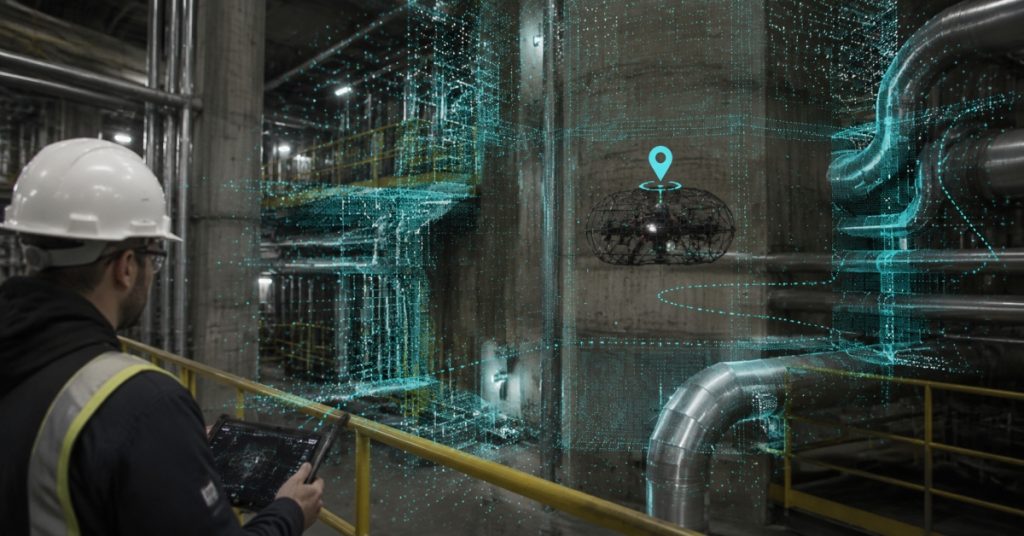
For drones, this becomes especially useful in GPS-denied environments. A drone flying inside a warehouse or tank can’t depend on satellite positioning. Instead, it has to use sensors and SLAM algorithms to understand its surroundings and estimate its position while it flies.
How Are People Using SLAM?
SLAM is used across many types of robotics and autonomous systems that need to understand their surroundings and determine their position without relying on a fixed map or external positioning system.
Some comon SLAM applications are:
- Drones. Helping aircraft navigate indoor, underground, and other GPS-limited environments where traditional positioning methods may not work reliably.
- Autonomous vehicles. Allowing vehicles to understand road layouts, obstacles, and their position within changing environments.
- Mobile robots. Helping robots move through warehouses, factories, and other indoor spaces while building a map of their surroundings.
- Augmented reality (AR). Enabling devices to understand their physical environment so digital information can be placed accurately within the real world.
- Industrial automation. Supporting robots and machines that need to navigate complex spaces and interact with physical environments.
For drone operators, these broader applications help explain why SLAM is such an important capability.
The same core challenge appears across many robotic systems: understanding where the machine is while also understanding the environment around it.
How Does SLAM Work?
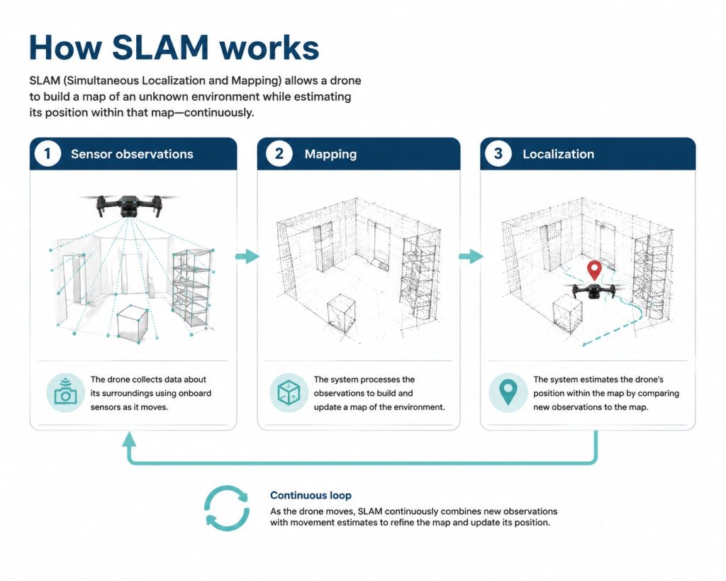
SLAM works by combining sensor data with software that estimates movement and builds a map of the environment at the same time.
A drone equipped with SLAM doesn’t begin with a complete understanding of its surroundings. Instead, it builds that understanding as it flies.
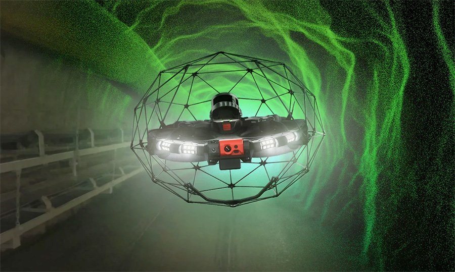
The Elios 3 uses SLAM to map confined spaces for industrial inspections | Credit: Flyability
As the drone moves, onboard sensors collect information about nearby objects and surfaces. The SLAM system uses those observations to estimate how the drone has moved, add new information to its map, and refine its understanding of where it is.
The three main parts of the SLAM process are:
1. Mapping
The mapping part of SLAM creates a representation of the environment around the drone.
Depending on the system, that map may include walls, structures, equipment, and other features detected by the drone’s sensors.
For example, a drone inspecting the inside of a large industrial vessel may begin with little information about the space. As it flies, SLAM helps it build a more complete picture of the environment.
2. Localization
Localization is the process of estimating the drone’s position within that map.
The system compares new sensor observations with information it’s already collected.
By recognizing features it has seen before, the drone can estimate how far it’s moved and where it’s located. And this is what allows SLAM-equipped drones to operate in environments where GPS can’t provide reliable positioning.
3. Loop Closure
One challenge with SLAM is that small errors can add up as the system estimates movement over time.
Loop closure helps correct those errors.
If a drone returns to an area it’s previously observed, the SLAM system can recognize that the location matches an earlier part of the map. It can then use that information to improve the consistency of the map and refine its position estimate.
How Do Drones Use SLAM?
For drone operators, the biggest value of SLAM is improved positional awareness in complex environments.
Consider a drone inspecting the inside of a storage tank. The drone may need to navigate around curved walls, internal structures, pipes, and other obstacles without a reliable GPS signal.
A SLAM system uses onboard sensors to track those surroundings and estimate the drone’s movement through the space. This can help the drone maintain a better understanding of where it is and where it has already flown.
How SLAM Supports Drone Operations
The information SLAM provides can help with several parts of a drone operation:
- Navigation. Helping the drone move through environments where GPS is unavailable.
- Mapping. Creating a representation of the environment as the drone flies.
- Inspection awareness. Helping operators understand the drone’s location relative to the asset being inspected.
SLAM can also support autonomous or assisted flight features. But SLAM itself isn’t the same thing as autonomy.
A drone can use SLAM to understand its position without making independent decisions about where to fly next. Autonomy usually requires additional systems for route planning, obstacle detection, flight control, and mission execution.
For most drone operators, the practical takeaway is: SLAM becomes valuable when the environment is too complex, enclosed, or GPS-limited for traditional positioning methods to work reliably.
To make this more concrete, here’s a 3D model of a tunnel made with SLAM on the Flyability Elios 3:

Drones that Use SLAM
A “SLAM drone” isn’t usually sold as a standalone drone category.
Instead, it’s a capability that drone makers integrate into drones and their autonomy systems to help platforms understand their surroundings and operate in challenging environments.
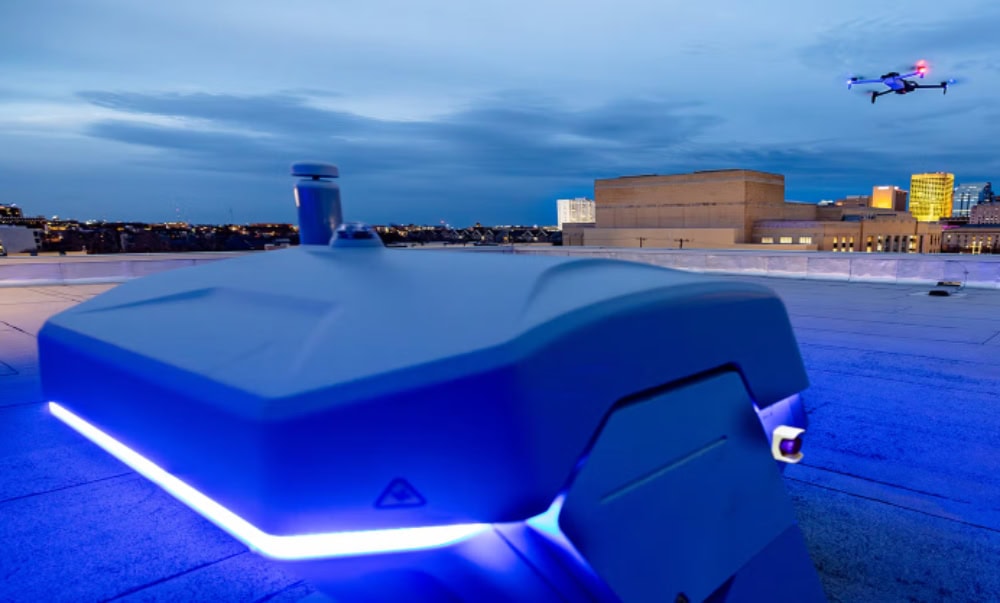
SLAM is a key part of the technology that allows Skydio drones to fly autonomously | Credit: Skydio
Prominent drone companies using SLAM include:
- Skydio. Skydio uses SLAM-based computer vision and spatial awareness technologies as part of its autonomous flight systems. These capabilities help drones understand their surroundings, navigate complex environments, and track objects while flying.
- DJI. DJI incorporates SLAM-related technologies into some of its autonomy and positioning systems. By combining information from cameras, IMUs, and other sensors, these systems help drones maintain awareness of their position and surroundings.
- Flyability. Flyability’s indoor inspection drone the Elios 3 uses SLAM technology to help operators navigate GPS-denied environments like tanks, tunnels, and other confined spaces. The system helps create a spatial understanding of the environment while supporting inspection workflows.
For drone pilots, the key takeaway is that SLAM is usually one part of a larger navigation system.
The value comes from how the technology works together with sensors, software, and the mission requirements.
5 Most Common SLAM Drone Use Cases
SLAM drones are most useful in environments where understanding the surrounding space is just as important as knowing the drone’s position.
These are typically places where you can’t rely on GPS.
By using onboard sensors to build a map while estimating its position in three dimensional space, SLAM-enabled drones help pilots navigate complex spaces, collect inspection data, and understand exactly where findings are located within an environment.
Here are the five most common use cases for SLAM drones.
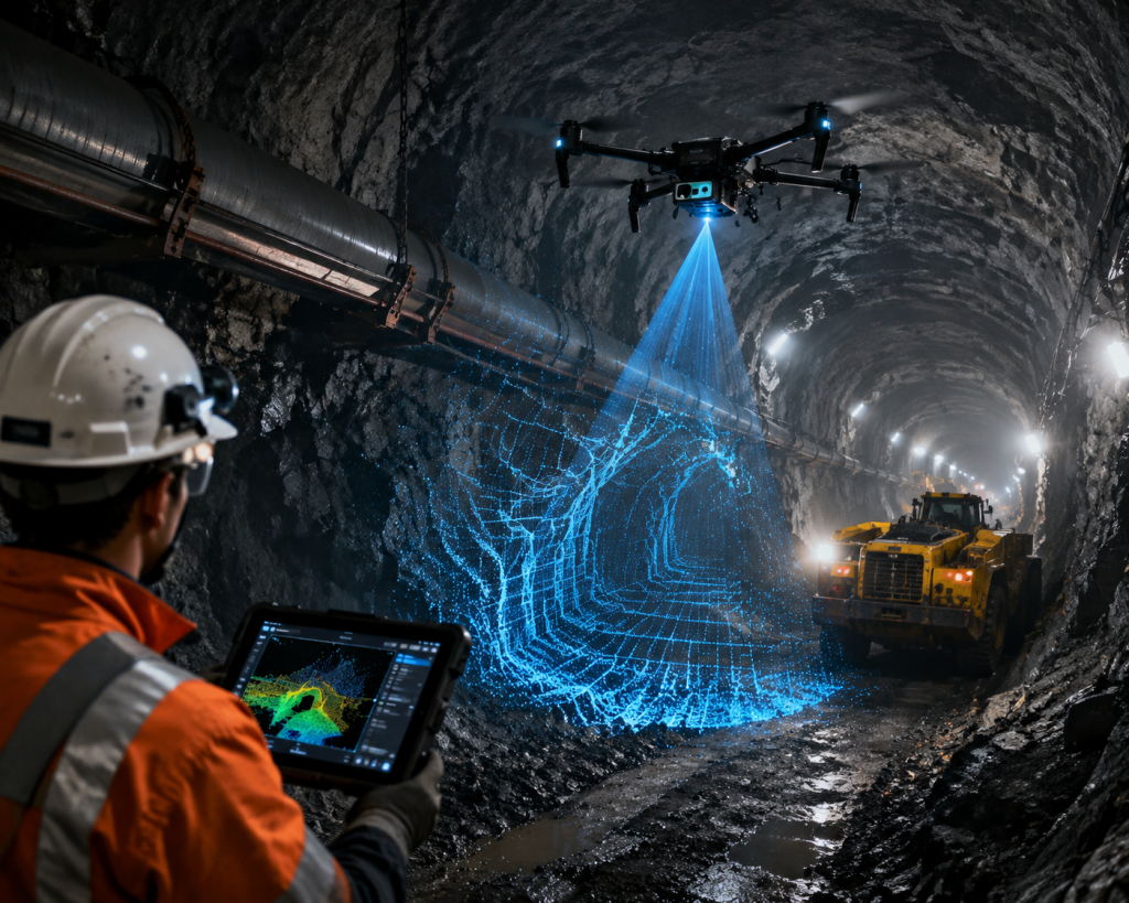
1. Mining Operations
Mines create some of the most challenging conditions for flying a drone.
Underground mines often combine long tunnels, limited visibility, changing environments, and a complete lack of GPS availability. A drone flying underground needs another way to understand where it is and how different areas connect.
SLAM can help mining teams create maps of underground environments while maintaining awareness of the drone’s location. This can support inspections, documentation, and surveying workflows in areas that may be difficult or unsafe for people to access.
SLAM drones help mining operations by:
- Mapping underground spaces. Creating a digital representation of tunnels, chambers, and other mine structures.
- Supporting remote inspections. Allowing teams to collect information from areas that may present safety risks.
- Improving situational awareness. Helping operators understand where the drone has flown and what areas have been documented.
- Providing location context. Associating observations and findings with specific areas inside complex underground environments.
2. Industrial Inspections
Industrial inspection is one of the most common ways drones equipped with SLAM are being used today.
Facilities often contain areas that are hard or dangerous for people to access, including tanks, vessels, or boilers—all places where GPS won’t work.
SLAM helps the drone understand its location relative to the asset it’s inspecting, while also building a 3D map of the surrounding environment.
This map not only helps fly the drone, it also helps document the location of potential defects within an asset, allowing maintenance teams to return to that place for a closer look.
SLAM drones help industrial inspection teams by:
- Navigating GPS-denied environments. Helping drones operate inside structures where satellite positioning is unavailable.
- Creating spatially accurate maps. Building a representation of the inspection area as the drone flies.
- Locating inspection findings. Connecting images, measurements, or defects to specific locations within the mapped environment.
- Reducing the need for human entry. Allowing teams to inspect difficult-to-access areas without relying as heavily on scaffolding, rope access, or confined-space entry.
3. Tunnels and Transportation Infrastructure
Transportation infrastructure like subway tunnels and utility passages can be challenging places to fly a drone.
These spaces often have little or no GPS availability, long corridors, repetitive features, and limited access for inspection crews. To fly here, a drone needs a reliable way to estimate its position while moving through the environment.
SLAM helps by using information from the surrounding structure to track movement and build a map of the tunnel or passage. This map gives operators a better understanding of where the drone has traveled, and where specific findings are located.
SLAM drones help transportation teams by:
- Inspecting hard-to-reach areas. Collecting visual data from tunnels and infrastructure where access may be difficult.
- Maintaining location awareness. Helping operators understand the drone’s position throughout long inspection routes.
- Creating reference maps. Building spatial records that help teams review infrastructure conditions.
- Supporting maintenance planning. Providing better location context for issues discovered during inspections.
4. Large Indoor Facilities
Large indoor spaces like warehouses, manufacturing facilities, and industrial buildings can also create challenges for drone positioning.
While these environments may not always be completely GPS-denied, signals can become unreliable indoors or around large structures. To ensure full coverage during an inspection or 3D mapping, drone pilots may need to navigate complex layouts while keeping track of where they’ve already flown.
SLAM can help drones maintain positional awareness while collecting data inside these environments. This can support inspection, inventory, documentation, and other workflows where knowing the drone’s location matters.
SLAM drones help indoor facility operators by:
- Navigating complex layouts. Helping drones move through large spaces with limited GPS availability.
- Building indoor maps. Creating a reference of the environment during flight.
- Tracking inspection coverage. Helping teams understand which areas have been documented.
- Improving repeatability. Supporting future flights by providing a better understanding of the environment.
5. Public Safety and Search Operations
Emergency responders may encounter GPS-limited environments during search and rescue operations, especially inside damaged buildings, collapsed structures, or other hazardous areas.
In these situations, a SLAM-enabled drone can help teams understand an unfamiliar space while reducing the need to send people into potentially dangerous conditions.
The usefulness of SLAM depends on the environment and equipment involved, but the ability to build a 3D map while tracking position can provide valuable context during time-sensitive operations.
SLAM drones help public safety teams by:
- Exploring dangerous environments. Allowing responders to gather information before entering unstable or hazardous areas.
- Building situational maps. Helping teams understand the layout of unfamiliar spaces.
- Tracking areas searched. Providing better awareness of where the drone has already collected information.
- Supporting response decisions. Giving teams additional information when planning next steps.
Types of SLAM
SLAM isn’t one single technology.
Different SLAM systems use different sensors and approaches to understand the surrounding environment and estimate movement.
The right approach depends on where the drone is flying and what information it needs to collect. A drone flying in a well-lit indoor space may rely heavily on visual cameras, while a drone inspecting a dark industrial structure may rely on LiDAR or a combination of multiple sensors.
The three most common approaches to SLAM are visual SLAM, LiDAR SLAM, and visual-inertial SLAM.
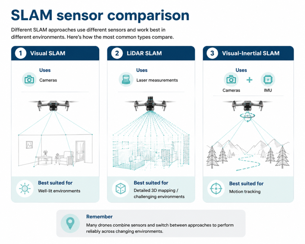
1. Visual SLAM
Visual SLAM uses cameras to understand the environment around the drone.
The system analyzes features in camera images—things like edges, corners, and patterns—to track movement, recognize areas it’s already seen, and build a map as the drone flies.
- Uses: Camera images and visual features from the surrounding environment.
- Best suited for: Well-lit environments with clear visual features, like indoor spaces with visible walls, equipment, or structures.
- Limitations: Performance can decrease in low light, smoke, dust, reflective environments, or spaces with few unique visual features.
2. LiDAR SLAM
LiDAR SLAM uses laser measurements to understand the shape and distance of objects around the drone.
A LiDAR sensor sends out laser pulses and measures how those signals reflect from nearby surfaces. The system uses those measurements to create a detailed map of the environment and estimate the drone’s position within that space.
- Uses: Laser measurements that capture distances to surrounding objects and structures.
- Best suited for: Complex industrial environments where accurate spatial measurements are important, including dark tanks, tunnels, and other GPS-limited spaces.
- Limitations: LiDAR sensors typically add cost, weight, and complexity compared with camera-based systems.
3. Visual-Inertial SLAM
Visual-inertial SLAM combines camera data with information from an inertial measurement unit (IMU).
An IMU measures changes in movement, acceleration, and rotation. By combining that information with visual observations, the system can better track the drone’s motion and estimate its position, especially during movement or when visual conditions change.
- Uses: Camera data combined with motion and orientation information from an IMU.
- Best suited for: Applications where the drone needs more reliable motion tracking during movement or changing visual conditions.
- Limitations: Requires additional sensor integration and depends on the quality of both visual and motion data.
Choosing a SLAM Drone: What to Consider
Choosing a SLAM-enabled drone is about more than selecting the most advanced sensor package.
The right system depends on where the drone will operate, what information needs to be collected, and the conditions it will encounter during a mission.
Choosing the Right SLAM Approach
For drone operators, the best SLAM approach depends on:
- The environment: Where will the drone fly?
- The data needed: What information does the mission require?
- The operating conditions: What challenges will the sensors need to handle?
A camera-based system may work well in a well-lit indoor environment with clear visual features.
But a drone flying inside a dark tank, underground tunnel, or complex industrial structure may benefit from LiDAR or a combination of multiple sensors.
Here’s a quick framework for comparing SLAM approaches:
[table “” not found /]Understanding SLAM Limitations
SLAM can help drones operate in environments where GPS is unavailable or unreliable, but it is not a universal solution for every flight condition.
Like any navigation system, SLAM depends on the quality of the information it receives. The sensors, environment, and flight conditions all influence how accurately the system can estimate position and build a map.
One of the biggest factors is whether the environment provides enough useful information for the system to track movement.
A space with clear features—such as walls, pipes, equipment, or structural elements—gives SLAM more reference points. Environments with few unique features can make localization more difficult.
For example, a long corridor with repeating walls and similar-looking areas may be more challenging than a room with varied objects and surfaces.
Conditions that can create challenges include:
- Low visibility: Camera-based SLAM systems may struggle when lighting is poor or when there are few visible features to track.
- Dust, smoke, or airborne particles: Environmental conditions can affect how sensors collect information.
- Repetitive environments: Similar-looking areas can make it harder for the system to determine its exact position.
- Reflective or difficult surfaces: Certain materials may affect how sensors interpret the environment.
- Computing requirements: SLAM requires processing power because the system continuously analyzes sensor data and updates its position estimate.
These limitations do not make SLAM unsuitable for challenging drone operations. They simply mean that the technology needs to match the environment.
A SLAM drone designed for indoor inspection may perform very differently from a system designed for another type of mission. The important question is not whether a drone uses SLAM, but whether the drone’s sensors, software, and overall design are suited to the conditions where it will operate.
SLAM vs. GPS, LiDAR, Photogrammetry, and Obstacle Avoidance
SLAM is often discussed alongside GPS, LiDAR, photogrammetry, and obstacle avoidance because all of these technologies help drones understand and operate in the world around them.
But they solve different problems.
Understanding the difference helps you evaluate what a drone system can actually do.
Here’s a quick overview:
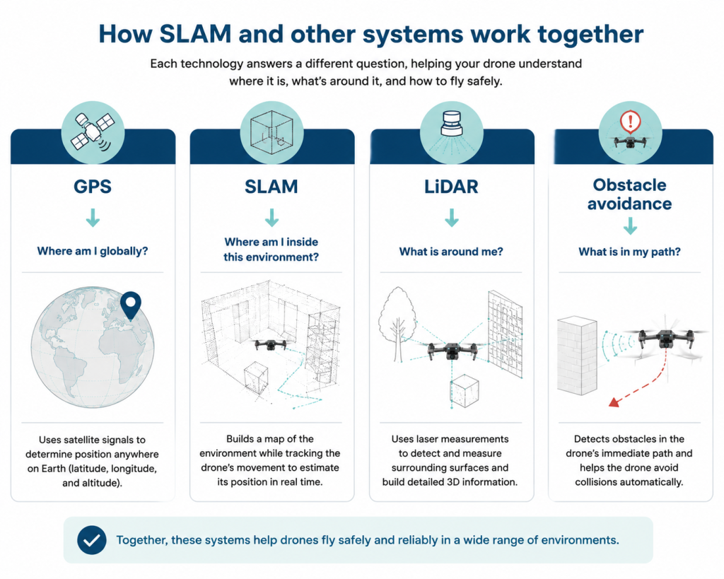
SLAM vs. GPS
- GPS asks: “Where am I on Earth?”
- SLAM asks: “Where am I inside this environment?”
GPS uses satellite signals to help drones determine their global position and is the primary positioning method for many outdoor flights.
SLAM works differently by using information from the surrounding environment to estimate position. This makes it especially useful indoors, underground, or in other locations where GPS signals are unavailable or unreliable.
SLAM vs. LiDAR
- LiDAR asks: “What is around me?”
- SLAM asks: “Where am I, and how does this environment fit together?”
LiDAR is a sensor technology that measures distances to nearby objects and surfaces. SLAM is a process that uses information from sensors—including LiDAR, cameras, and other inputs—to build a map and estimate position.
A drone can use LiDAR as part of a SLAM system, but LiDAR alone does not automatically provide localization or mapping.
SLAM vs. Photogrammetry
- Photogrammetry asks: “What does this area look like?”
- SLAM asks: “Where am I as I move through this environment?”
Photogrammetry typically creates maps and 3D models by processing images collected during a flight. SLAM works in real time, helping the drone understand its position while it is operating.
The two technologies can also work together, with SLAM supporting navigation while photogrammetry or other workflows create final mapping deliverables.
SLAM vs. Obstacle Avoidance
- Obstacle avoidance asks: “Is there something in my path?”
- SLAM asks: “Where am I, and what does my environment look like?”
Obstacle avoidance helps drones detect nearby objects and reduce collision risk. SLAM helps drones understand their position within a space and build a representation of the environment around them.
A drone inspecting a complex structure may use both capabilities together—obstacle avoidance to help avoid collisions and SLAM to support navigation and spatial awareness.
SLAM Drone and Simultaneous Localization and Mapping FAQ
Here are answers to some of the most commonly asked questions about simultaneous localization and mapping and SLAM drones.
What does SLAM stand for?
SLAM stands for simultaneous localization and mapping.
It describes a process where a drone or robot builds a map of its surroundings while simultaneously estimating its own position within that environment.
What is a SLAM drone?
A SLAM drone is a drone that uses simultaneous localization and mapping to understand its position and surroundings while flying.
These drones are typically used in environments where GPS is unavailable or unreliable, such as indoor spaces, tunnels, mines, and industrial structures.
Are SLAM drones autonomous?
Not necessarily. SLAM can support autonomous flight by helping a drone understand its location and surroundings, but SLAM itself does not make a drone autonomous.
Autonomous systems usually require additional capabilities for flight control, route planning, obstacle detection, and decision-making.
Is LiDAR the same as SLAM?
No. LiDAR is a sensor technology that measures distances using laser pulses. SLAM is a process that uses sensor information to estimate position and create a map.
Many SLAM systems use LiDAR, but SLAM can also use cameras, IMUs, and other sensor inputs.
Can SLAM work without GPS?
Yes. One of the main reasons SLAM is useful for drones is that it can help estimate position in environments where GPS is unavailable or unreliable.
Instead of relying on satellites, the system uses information from the surrounding environment to understand movement and location.
Do all drones use SLAM?
No. Most consumer drones are designed for outdoor flight and rely primarily on GPS and other positioning systems.
SLAM is more common on specialized drones designed for challenging environments, including indoor inspection, confined spaces, and other GPS-limited operations.
Are SLAM drones better than GPS drones?
Not always. SLAM and GPS solve different problems.
GPS is usually the better option for many outdoor flights, while SLAM becomes valuable when a drone needs to operate in environments where satellite positioning is limited.
The right choice depends on where the drone will fly, what data it needs to collect, and the conditions of the mission.