


Mapping & Modeling for
Drone Pilots
Use photogrammetry to create accurate 2D maps and 3D models, from mission plan to data capture and processing.
- 3 live Zoom sessions with structured lesson plans and live Q&A
- Experienced instructor, real photogrammetry case studies and practice assignments
- Free access to online mapping course (usually $179) included with workshop sign-up
What You’ll Learn
Where Mapping Is Used and Why It’s Useful
Explore industry use cases like construction progress, disaster response, vegetation management, and crop health.

How Drone Mapping Actually Works
Understand the full process from planning a flight to creating a finished map, broken down step-by-step in plain English.

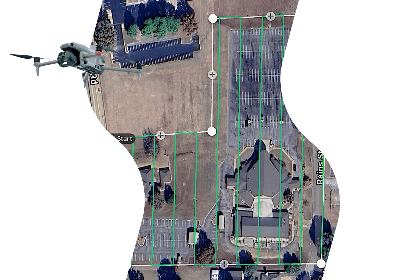
How to Plan and Capture a Mapping Flight
Learn what goes into a successful mapping mission, including how to plan your flights and how to make your data accurate.
Real Examples from Pilots in the Field
This Workshop is a Great Fit If:
- You know how to fly a drone and want to expand your skillset
- You’re curious about mapping but don’t know where to start
- You want to add mapping as a service or revenue stream
- You prefer live, guided training over figuring it out on your own
- You’ve seen drone mapping before but it hasn’t fully clicked yet

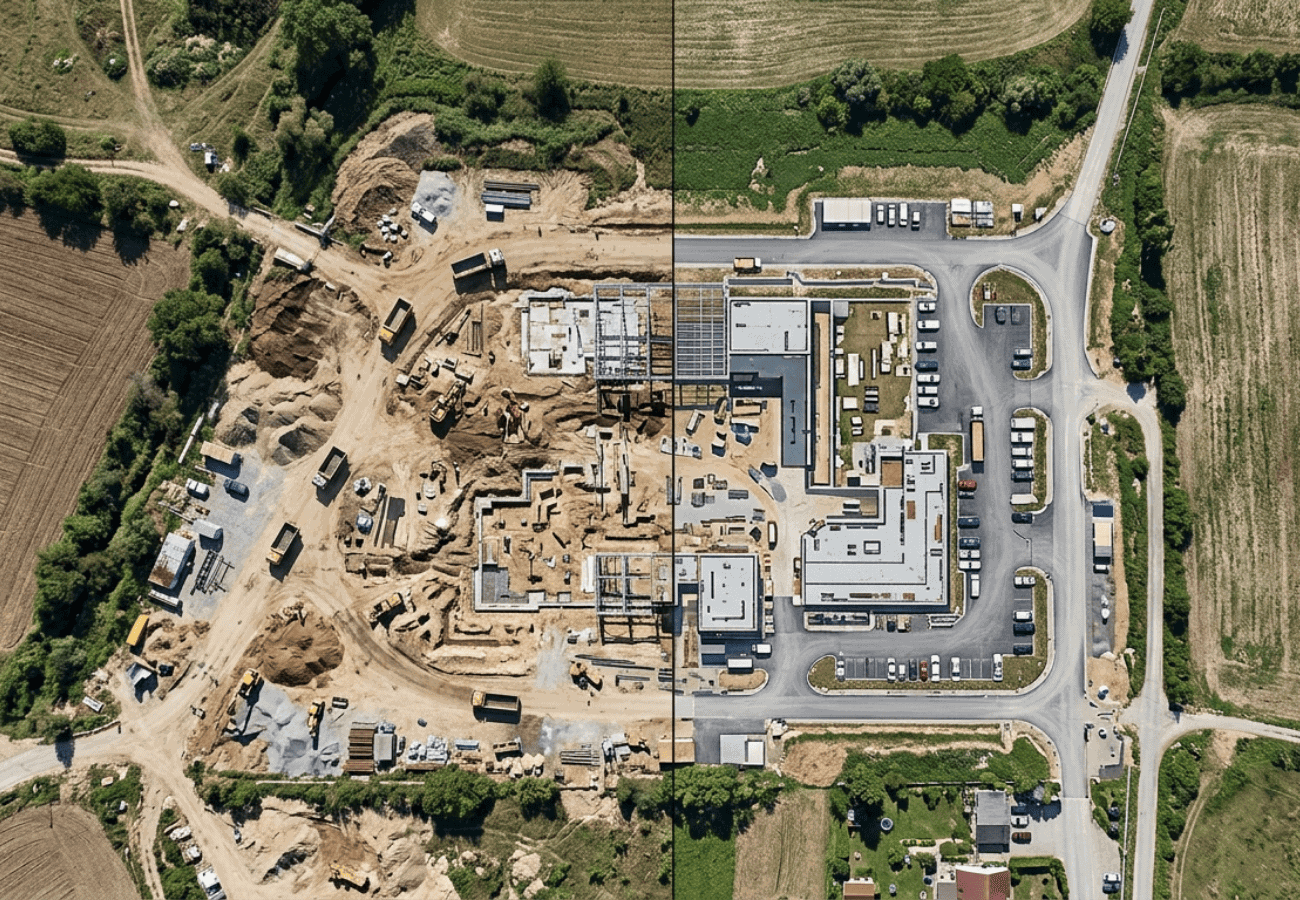
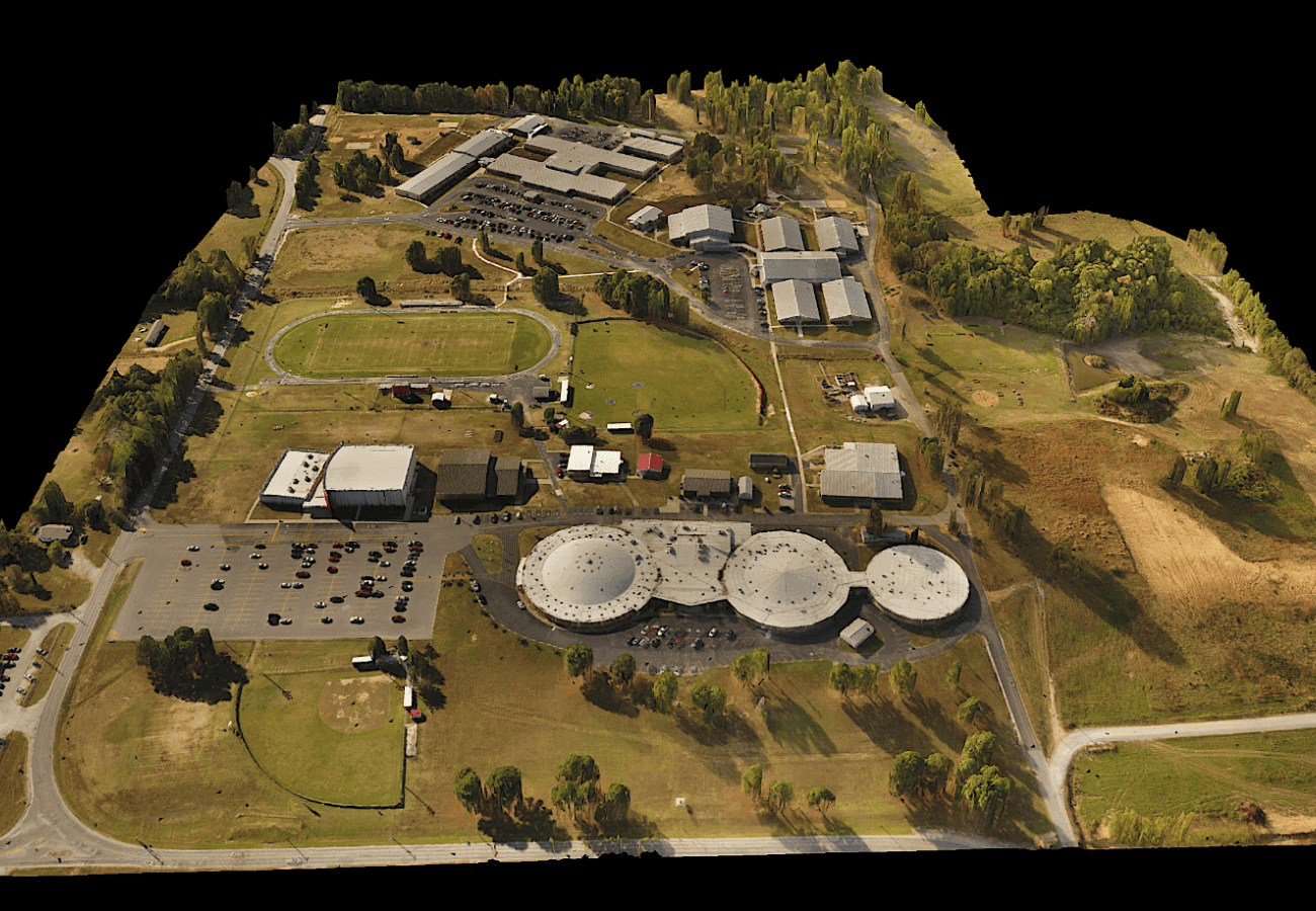
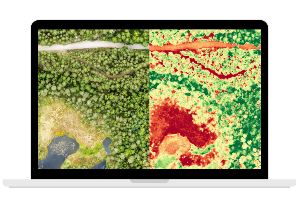
High Resolution Data for Smarter, Faster Decision-Making
Imagine flying over a site in a planned pattern, taking many highly accurate images, and using software to combine them into a detailed 2D map or 3D model including:
- Orthomosaic Map
- Digital Surface Model
- Digital Terrain Model
- Normalized Difference Vegetation Index (NDVI)
Map
Drone mapping transforms aerial images into useful insights that help teams and stakeholders make faster, better informed decisions in construction, agriculture, surveying, and more.
Workshop Dates
JUNE COHORT
3 weekly sessions on Tuesday evenings
JUNE 16, 23, 30
8-10p Eastern / 7-9p Central / 5-7p Pacific
Location: Virtual on Zoom
$699
Sign-ups have closed
JULY COHORT
3 weekly sessions on Thursday evenings
JULY 9, 16, 23
8-10p Eastern / 7-9p Central / 5-7p Pacific
Location: Virtual on Zoom
$699
Important Details:
- Each cohort is capped at 15 participants
- Includes free access to Mapping for Drone Pilots online course (usually $199)
- Sign-ups close 24 hours before the first session
Workshop Agenda
Attend 3 live workshop sessions (2 hours each) — plus complete homework assignments in between sessions to help you practice and master each skill.
Week 1 — Photogrammetry Orientation, Equipment & Accuracy
- Drone Mapping vs Modeling
- What is Photogrammetry?
- Mapping: 2D Outputs
- Modeling: 3D Outputs
- Drone Platforms & Equipment Costs
- Drone Mapping Platforms
- Electronic vs. Mechanical Camera Shutters
- Purpose-Built Mapping Drones
- Advanced Mapping Platforms
- Positioning & Accuracy Equipment
- LiDAR: A Parallel Mapping Technology
- The Art of Accuracy
- Relative vs. Absolute Accuracy
- Survey-Grade Data
- Tools to Improve Accuracy
- Ground Sampling Distance & Flight Patterns
- Ground Sampling Distance (GSD)
- Drone Flight Patterns
- Questions, Recap, Assignment
Week 2 — Settings, Flight Planning & Data Capture
- Light, Camera Settings & Image Quality
- Lighting
- Shutter Speed
- Distortion Correction
- Shutter Type
- Lens Choice
- Pre-Flight Workflow & Field Execution
- Client Communication & Site Research
- Airspace Research & Mission Planning
- Programming Your Autonomous Flight
- Pre-Flight Checks & On-Site Setup
- Running the Mission
- Questions, Recap, Assignment
Week 3 — Data Processing & Real-World Applications
- Post-Flight Data Processing
- Photogrammetry Software Options
- Post-Flight Workflow
- Real-World Scenarios
- Scenario 1
- Scenario 2
- Scenario 3
- Scenario 4
- Questions, Recap, Assignment
When I need help, Mike was there to answer my questions and I enjoyed attending the weekly virtual meetings.
Jonathon B.
North Carolina
Great training with very useful hands on exercises to help walk through mission planning, the mission, downloading and processing to create amazing deliverables.
Matthew
Iowa
I was looking for an understanding on the wide options of drone mapping and during this class I got all my questions answered. Amazing knowledge transfer.
New T.
Florida
Key Takeaways
You’ll leave this workshop confident in your ability to:
- Plan & execute a mapping mission
- Capture usable, high-quality aerial data
- Understand the full mapping workflow
- Speak confidently about mapping in professional settings
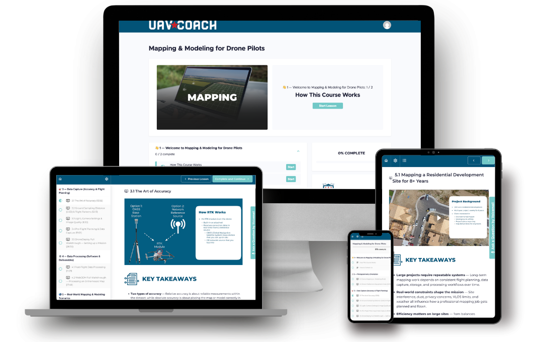
Online Course: Mapping for Drone Pilots
$179 Included in the price of your workshop sign-up
- Companion to the virtual workshop
- Real mapping projects
- 11 highly-produced video lessons + full lesson text
- Lifetime access to course content
- One-on-one support via phone and email
Why Choose Us
1
Live instructor-led training
2
Real-time Q&A and Guidance
Get your questions answered during each session so you can move forward with confidence, not confusion.
3
lifetime
access
Enjoy lifetime access to all course materials, keeping you updated with the latest information long after you enrolled.
Your Instructor

Mike McGuirt
Drone Flight Instructor, UAV Coach
Since 2017, Mike McGuirt has been teaching drone concepts to UAV Coach students both in person and virtually. He has helped thousands of people pass the FAA Part 107 exam and is a trusted resource for drone pilots at every stage. Mike has done numerous mapping projects for clients in his area and draws upon his experience for this workshop.
Mike served nearly 28 years in the U.S. Air Force, where he held various management and leadership roles in human resources, supporting personnel around the globe. He also spent 3 years as a high school Aerospace Science Instructor, where he started and grew the drone program. Mike has a BS in Industrial Technology from Southern Illinois University and an MA in Management and Leadership from Webster University.
Frequently Asked Questions
About the workshop
How does a live virtual workshop work?
This is an instructor-led training delivered over Zoom for a small group of people.
A day before the workshop begins, you’ll receive an email with a Zoom link to attend each session.
About 5-10 minutes before each session, use the Zoom link to log in from your computer, laptop, or tablet and join the live training. During the session, our instructor will use slides and visuals to guide you step-by-step through the material, with opportunities to ask questions.
Do I need a drone to take this workshop?
No drone is required. The workshop focuses on understanding the mapping process rather than flying.
Do I need to have my Part 107 to take this workshop?
No. You do not need a Part 107 certification to participate. The workshop is open to both certified and non-certified pilots.
However, if you plan to use drone mapping commercially (taking on paid work), you will need a Part 107 certificate to operate legally in the U.S. If you’re working toward that, you can check out Drone Pilot Ground School, which helps pilots prepare for the FAA Part 107 exam.
What are the technical requirements?
You’ll need a reliable internet connection and a device that can access Zoom (laptop or desktop is best).
What's the time commitment?
The workshop includes 3 live sessions, each 2 hours long. In addition, homework is assigned after each session that will take 1-2 hours a week.
How do I join the workshop?
Once you register, you’ll receive an email with your Zoom link and access details before the first session. On workshop days, just click the link 5 minutes before start time and you’re in.
Will there be homework?
Assignments will be given at the end of each workshop session to complete ahead of the next workshop.
Do I get any reference materials after the workshop?
Yes—you get lifetime access to our online course Mapping for Drone Pilots, which includes 11 highly produced videos with full lesson text.
Will I receive a certificate upon completion?
Yes—you’ll receive a certificate of completion after finishing the workshop.
Do I get a recording of each session?
Yes. Every session is recorded and shared with participants after each class so you can revisit anything or catch up if needed.
What if I have to miss one of the sessions?
We strongly recommend attending live if possible, since each session builds on the previous one. If you miss a session, you’ll still get access to the recording so you can catch up.
What's the cancellation policy?
You can cancel up to 7 days before the workshop for a full refund. After that, your registration can be transferred to a future cohort.
PAYING FOR THE WORKSHOP
How do we pay for our team to take the workshop?
Contact us at 888-626-1490 or enroll@uavcoach.com, and we’ll send an invoice to you and/or the appropriate person in your organization. We accept payments by credit card, ACH, PayPal and check.
Can you process purchase orders?
We’re happy to accept POs and can complete any vendor paperwork necessary.
My organization is tax-exempt - how can we sign up?
If your organization is tax-exempt, please email a copy of your state-issued tax-exempt form to enroll@uavcoach.com, including the number of people you wish to enroll.
We already signed up and paid tax even though we’re tax exempt - what can we do now?
Send a quick email, including a copy of your purchase receipt and your state sales tax exemption certificate, to enroll@uavcoach.com. We’ll refund your original purchase and reissue a tax exempt invoice for payment.
Customer support
What do I do if I need help?
We’re here to help! For technical support as well as questions about the course content, email us at support@uavcoach.com. You can also leave us a voice message by pressing the “Ask a Question by Voicemail” button inside the course.
What if I’m unhappy with the workshop?
We want to hear from you. Email us at support@uavcoach.com and give us your feedback. If we can’t make it right, you can rely on our 30 Day Money Back Guarantee.
Questions about signing up? Email enroll@uavcoach.com or call us at 888-626-1490.


