Commercial Drone Pilot in Kentucky Surveys Damage from Last Weekend’s Onslaught of Tornadoes

BY Zacc Dukowitz
16 December 2021

Last weekend, tornadoes ripped through nine different states, destroying homes and killing people.

The storm began on Friday night and continued into Saturday morning. The number of tornadoes was at least 30, sweeping primarily across northeast Arkansas, southeast Missouri, western Kentucky, and northwest Tennessee.

tornado-damage-drone-header
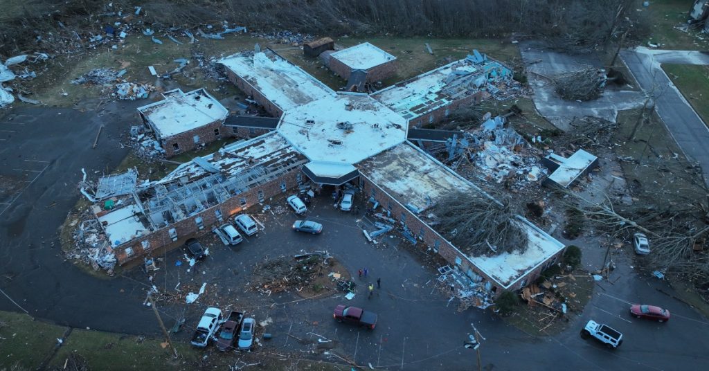
Credit: Whitney Westerfield

This was one of the biggest, most destructive storms we’ve seen in the last 100 years. Meteorologists are investigating what may have caused it, with some expressing concern that rare storms like these may become more common as the weather continues to grow warmer.

The scale of damage caused by this storm is hard to fathom.

It’s estimated that over 100 people died as a result of the storm, with Kentucky by far the hardest hit. 74 people have been confirmed dead in the state and, of the approximately 250 miles that the tornadoes covered, about 200 of those miles were in Kentucky.

Regarding that 250-mile distance, researchers are trying to determine whether a single tornado tracked that entire path. If it did, it would be the longest recorded tornado path in history. Currently, the longest tornado path in history is from the “tri-state” tornado of 1925, which traveled 219 miles through the states of Indiana, Illinois, and Missouri.

Kentucky Drone Pilot, State Senator Scans Wreckage from the Air

In the town of Mayfield, Kentucky, a local commercial drone pilot quickly put his drone in the air on Saturday morning to survey the scene. The pilot’s name is Whitney Westerfield, and he’s also a state senator.

Mayfield was one of the towns hardest hit by the tornadoes. Mayfield is where a candle factory was destroyed while people were still at work late at night, and where so many homes were destroyed that Kathy Stewart O’Nan, the town’s mayor said, “it looks like a bomb has gone on off here.”

These drone images captured by Westerfield convey the scale of the damage:

[Did you know? The Special Governmental Interest (SGI) process enables certain parties responding to natural disasters to get emergency waivers from the FAA.]

How Drones Help After Natural Disasters

Following a disaster like this, drones can be used in a number of ways to help with relief and recovery efforts.

Here are the five of the most common uses for drones after a disaster:

1. Finding People in Need of Help

At this point, most of us have read about how law enforcement uses thermal drones to find missing people at night. In those instances, the missing person is usually someone quite old who has lost their way at night, or someone who has been ejected from a car following an accident.

But drones equipped with thermal and visual sensors are also used to help find people after a natural disaster, such as a tornado—or even a massive landslide. Earlier this year, the biggest drone operation ever conducted in Europe took place as part of a massive rescue effort following a huge landslide in Norway.

Several missing after landslide hits Norwegian town

2. Assessing the damage

Drones can help city administrators understand the extent of the damage following a major event like a tornado, flood, or earthquake. Aerial footage can be invaluable for shaping the understanding of the scope of damage, which can in turn inform decision-making efforts on the ground.

flood-drones
Image source

3. Making determinations about where to focus resources

After a disaster it can be hard to know where to focus first. Drone surveys of damaged areas can help those working to address the damage and find victims, in order to decide how best to triage their efforts.

4. Delivering medical and other critical supplies

Emergency responders, fire fighters, and law enforcement can all benefit from using drones for quick deliveries following natural disasters. SGI waivers can be used to obtain permission for operations normally prohibited by the Part 107 rules, like flying BVLOS (Beyond Visual Line of Sight) in order to make emergency drone deliveries.

I think that the fire service is really at the forefront in package delivery. During [the] 2015 flood, we used drones to deliver body bags, AEDs, and a host of other equipment that our drones were capable of carrying.

– Gene Robinson, Experienced Search & Rescue UAV Pilot

Also, making drone deliveries within the pilot’s line of sight can be a helpful way to support emergency operations that doesn’t require special permission from the FAA.

5. Providing cell coverage

Cell towers can be damaged by hurricanes and other severe weather, knocking out cell phone capabilities in an area. This lack of communication can compound the issues people face after a disaster, isolating them further from the resources they might need.

But companies like AT&T are using drones to get cell services back up and running quickly after disasters.

These drones, called COWs (Cell on Wings), are essentially a cell site located on a drone that’s created to beam wireless coverage across an area. And they’re very effective—a single COW drone can provide coverage across an area of up to 40 square miles.

att-cow-drone-cell-service-fb
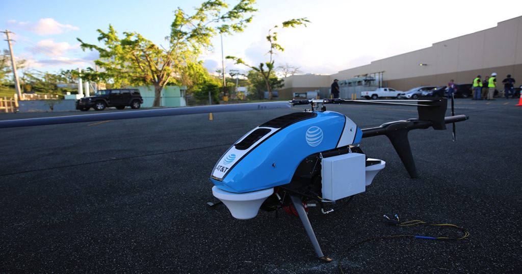
A COW drone in Puerto Rico | Credit: AT&T

Learn more about how drones are being used for good throughout the world.

Join a global community of

100,000+

drone enthusiasts.

Subscribe

Drone Pilot's Guide to DJI Mini 4 Pro

  • Navigate the DJI Fly app and flight modes with ease
  • Adjust camera and safety settings for better control
  • Understand intelligent flight features and how to use them
  • Avoid common beginner mistakes
  • Get the most out of your drone—without the guesswork

Drone Pilot's Guide to DJI Air 3S

  • Navigate the DJI Fly app and flight modes with ease
  • Adjust camera and safety settings for better control
  • Understand intelligent flight features and how to use them
  • Avoid common beginner mistakes
  • Get the most out of your drone—without the guesswork

Hands-On Flight Training

$295

400+ 5-Star Reviews

  • Team up with a knowledgeable, friendly instructor at a convenient outdoor spot — like a park or athletic field
  • Fly a top-rated drone provided for you, or bring your own to get personalized guidance
  • Spend most of your time in the air with hands-on practice — learning about composition, camera angles and cinematic motion
  • Explore the DJI Fly app and learn how to use camera settings like ISO, shutter speed and aperture
  • Unlock the power of Intelligent Flight Modes to fly smoother, smarter, and with less stress
  • Get access to our Aerial Photo & Video online course with additional exercises and pro-level editing workflows – using Snapseed, Photopea, Adobe Lightroom, DJI LightCut, and Premiere Pro

Aerial Photo & Video for Drone Pilots

$179

3,500+ 5-Star Reviews

  • How to dial in the right camera settings like ISO, shutter speed, and aperture
  • The best angles & altitudes for different types of shots (real estate, landscapes, cityscapes, and more)
  • The secret to cinematic drone motion that makes your footage feel like a Hollywood movie
  • How to enhance colors, remove distractions, and sharpen details – even in tricky lighting
  • Pro-level editing workflows – whether you’re using Lightroom, free tools, or mobile apps

The Recreational UAS Safety Test

Free

150+ 5-Star Reviews

  • Required for U.S. recreational flyers of drones
  • Launched June 2021 by the FAA
  • Takes about 30 minutes to complete
  • No prior drone knowledge needed
  • Test allows unlimited attempts to pass

Drone Mapping Essentials Workshop

$799

3,500+ 5-Star Reviews

  • Expert instruction from expert drone pilots with over 100 hours of flying experience
  • Hands-on training of live data capture and how to process deliverables for your clients
  • Peer-to-peer networking with other professional drone pilots in the mapping industry
  • Free access to the online course, Drone Mapping Essentials

Flight Skills for Drone Pilots

$99

75+ 5-Star Reviews

  • 16 engaging video lectures with key takeaways
  • Action items with concrete steps so you put into practice what you learn
  • Pre-flight checklists to help you plan your flights
  • Resource links to websites, products and software for further learning and discovery

Drone Business & Mapping Bundle

$617 $397

3,500+ 5-Star Reviews

  • Drone Pilot Ground School
    1. 1:1 support with a Part 107 exam success coach
    2. Study 100% online at your own pace
    3. Unlimited practice exams with 400+ real FAA test questions
  • Drone Mapping Essentials
    1. 100+ instructional videos focused on real-world application with high-quality videos
    2. Downloadable resources like data capture checklists to utilize in your missions
    3. Monthly live instruction with course instructor, Dylan Gorman, to go deeper on topics where you need more clarification
  • The Drone Business Blueprint
    1. Expert instruction from industry veteran, Eno Umoh, who brings real-world experience in building successful drone businesses.
    2. 14 Comprehensive modules covering everything from business setup to marketing strategies
    3. 30 Downloadable resources to apply your learning immediately

Hands-On Flight Training

$295

400+ 5-Star Reviews

  • 45-60 minutes of hands-on flying time to master orientation and flight maneuvers tailored to your skill level
  • Learn how to handle obstacles such as lost GPS, low battery charge or emergencies
  • Practice flying under various intelligent flight modes
  • Ask questions about regulations, software, flight operations management, and more

The Drone Business Blueprint

$119

3,500+ 5-Star Reviews

  • Expert instruction from industry veteran, Eno Umoh, who brings real-world experience in building successful drone businesses.
  • 14 Comprehensive modules covering everything from business setup to marketing strategies
  • 30 Downloadable resources to apply your learning immediately
  • AI tools and techniques to boost productivity and streamline your operations

Commercial Drone Business Bundle

$418 $334

4,000+ 5-Star Reviews

  • Drone Pilot Ground School
    1. 1:1 support with a Part 107 exam success coach
    2. Study 100% online at your own pace
    3. Unlimited practice exams with 400+ real FAA test questions
  • The Drone Business Blueprint
    1. Expert instruction from industry veteran, Eno Umoh, who brings real-world experience in building successful drone businesses.
    2. 14 Comprehensive modules covering everything from business setup to marketing strategies
    3. 30 Downloadable resources to apply your learning immediately

Drone Mapping Essentials

$199

3,500+ 5-Star Reviews

  • 100+ instructional videos focused on real-world application with high-quality videos
  • Downloadable resources like data capture checklists to utilize in your missions
  • Quizzes to test your knowledge so you can succeed in the field
  • Monthly live instruction with course instructor, Dylan Gorman, to go deeper on topics where you need more clarification

Drone Pilot Pro Bundle

$713 $499

3,500+ 5-Star Reviews

  • Drone Pilot Ground School
    1. 1:1 support with a Part 107 exam success coach
    2. Study 100% online at your own pace
    3. Unlimited practice exams with 400+ real FAA test questions
  • Drone Pilot Skill Builder
    1. 16 engaging video lectures with key takeaways
    2. Action items with concrete steps so you put into practice what you learn
  • Hands-On Flight Training
    1. 45-60 minutes of hands-on flying time to master orientation and flight maneuvers tailored to your skill level

Drone Pilot Ground School

$299

4,000+ 5-Star Reviews

  • 1:1 support with a Part 107 exam success coach
  • Study 100% online at your own pace
  • Unlimited practice exams with 400+ real FAA test questions
  • Personalized study plans, virtual flashcards, and 12-page cram sheet
  • Weekly webinars on acing the Part 107 exam and monthly webinars to elevate your journey post-certification