Landslide in Norway Leads to Largest European Drone Operation Ever, 200+ Hours of Flight Time Recorded

BY Zacc Dukowitz
17 February 2021

A recent landslide in the village of Ask, Norway led to the largest drone operation that has ever taken place in Europe.

Using a combination of drones and helicopters, emergency responders conducted a total of 420 missions looking for landslide victims over a period of several weeks, logging over 200 hours of flight time in the effort.

ask-landslide-drone-operation
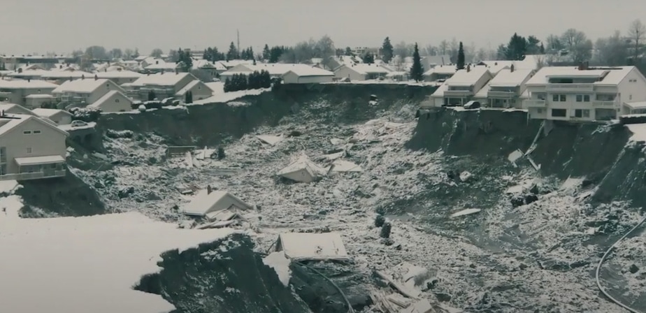
Some of the damage caused by the landslide in Ask

About the Landslide

The giant quick clay landslide hit the village of Ask at four in the morning on December 30th, 2020. It was 900 feet wide and 2,000 feet long at the time of impact, and it would ultimately grow to cover over 124 square miles.

In the first few hours after the landslide hit, first responders helped locate and rescue 13 people from collapsed houses throughout the town.

The landslide continued to move through the area as emergency personnel worked to remove people from the rubble. Over 1,000 people were evacuated over the next few days.

In total, the landslide destroyed 31 homes and killed seven people. Three more people are still missing.

Several missing after landslide hits Norwegian town

How the Rescue Operation Unfolded

In the first hour after the landslide the police flew a helicopter over the area, assessing the damage and looking for people who might be trapped in their homes.

Shortly after that, police tried launching a drone to support aerial search and rescue efforts, but it had to be taken down due to harsh weather.

More drones and helicopters arrived to help throughout the morning, along with troves of first responders and volunteers. Before long the airspace surrounding Ask was turned into a temporary no-fly zone, restricted to use only by those officially supporting rescue efforts.

As the operation in Ask unfolded it quickly developed in complexity. Here’s a list of all the different groups that supported rescue operations:

  • Soldiers from Norway’s elite task force Derby
  • 30 search teams with dogs
  • Rescue teams from the Oslo Fire Department
  • Local fire crews
  • The National Brigade of Norway
  • The Swedish USAR special crew

And here’s a list of the different vehicles used:

  • Several drones equipped with thermal cameras, provided by both police and fire departments (DJI’s Matrice 300 RTK was reportedly one of the models used)
  • Lockheed’s P-3 Orion surveillance aircraft
  • At least four helicopters
  • 25 ambulances

Intensive rescue efforts took place over a period of two days, with helicopters and drones constantly surveying the area for survivors.

During this time, emergency personnel were not allowed to try entering any of the collapsed homes to look for survivors because it was deemed too dangerous.

However, by the third day a few houses were determined safe enough to enter. Laying bright orange Styrofoam boards across the unstable mud, an elite specialist team from Sweden was able to begin entering the homes to continue the search for landslide victims.

That same day, rescuers also began preparing to use a giant army vehicle called a “paver,” which has a giant steel bridge that could allow them to cross wide sections of mud and debris.

Given the instability of the ground, rescuers had to stop their efforts to find people when the day grew dark. But drone operators continued searching throughout the night, using thermal cameras to try and locate survivors.

Managing the Complexity of Aerial Support

Throughout rescue operations in Ask, drones provided an effective tool to look for people trapped by the landslide.

The basic flow rescue personnel followed was to use drones to find and keep watch over landslide victims, and then use helicopters to fly in and rescue them.

ask-landslide-drone-rescue

Using both visual and thermal data, drone operators flew over the debris caused by the landslide, scanning carefully for signs of movement or a thermal signature that might indicate the presence of a person or an animal in need of help. (In addition to the many people rescued, a missing Dalmatian was found and rescued on the second day of the operation.)

The drones also helped first responders grasp the massive scope of the damage that had been done by the landslide.

When we arrived, the situation was complex and difficult to grasp. But when we got our first drone up, we started to understand the scope of the catastrophe.

– Kenny Åserud, Drone Pilot with Nedre Romerike Fire and Rescue

Drone operators involved in the rescue efforts included fire and police department personnel, military personnel, and one volunteer civilian pilot.

Given the number of drones and helicopters in the air supporting rescue operations communication was essential to avoid collisions.

Those in charge of aerial operations say that they managed the aerial congestion orally and by watching the skies while in flight.

The controlling of the drone resources were done old-fashioned and orally by standing next to each other overlooking the sunken landslide area.

– Jørgen Lunde Ronge, Drone Project Manager for the Norwegian police

Following the initial rescue effort drones continued to patrol the area around Ask for weeks, presumably looking for those who remain missing.

Know of other large-scale drone rescue operations? Share what you know in this thread on the UAV Coach community forum.

Join a global community of

100,000+

drone enthusiasts.

Subscribe

Drone Pilot's Guide to DJI Mini 4 Pro

  • Navigate the DJI Fly app and flight modes with ease
  • Adjust camera and safety settings for better control
  • Understand intelligent flight features and how to use them
  • Avoid common beginner mistakes
  • Get the most out of your drone—without the guesswork

Drone Pilot's Guide to DJI Air 3S

  • Navigate the DJI Fly app and flight modes with ease
  • Adjust camera and safety settings for better control
  • Understand intelligent flight features and how to use them
  • Avoid common beginner mistakes
  • Get the most out of your drone—without the guesswork

Hands-On Flight Training

$295

400+ 5-Star Reviews

  • Team up with a knowledgeable, friendly instructor at a convenient outdoor spot — like a park or athletic field
  • Fly a top-rated drone provided for you, or bring your own to get personalized guidance
  • Spend most of your time in the air with hands-on practice — learning about composition, camera angles and cinematic motion
  • Explore the DJI Fly app and learn how to use camera settings like ISO, shutter speed and aperture
  • Unlock the power of Intelligent Flight Modes to fly smoother, smarter, and with less stress
  • Get access to our Aerial Photo & Video online course with additional exercises and pro-level editing workflows – using Snapseed, Photopea, Adobe Lightroom, DJI LightCut, and Premiere Pro

Aerial Photo & Video for Drone Pilots

$179

3,500+ 5-Star Reviews

  • How to dial in the right camera settings like ISO, shutter speed, and aperture
  • The best angles & altitudes for different types of shots (real estate, landscapes, cityscapes, and more)
  • The secret to cinematic drone motion that makes your footage feel like a Hollywood movie
  • How to enhance colors, remove distractions, and sharpen details – even in tricky lighting
  • Pro-level editing workflows – whether you’re using Lightroom, free tools, or mobile apps

The Recreational UAS Safety Test

Free

150+ 5-Star Reviews

  • Required for U.S. recreational flyers of drones
  • Launched June 2021 by the FAA
  • Takes about 30 minutes to complete
  • No prior drone knowledge needed
  • Test allows unlimited attempts to pass

Drone Mapping Essentials Workshop

$799

3,500+ 5-Star Reviews

  • Expert instruction from expert drone pilots with over 100 hours of flying experience
  • Hands-on training of live data capture and how to process deliverables for your clients
  • Peer-to-peer networking with other professional drone pilots in the mapping industry
  • Free access to the online course, Drone Mapping Essentials

Flight Skills for Drone Pilots

$99

75+ 5-Star Reviews

  • 16 engaging video lectures with key takeaways
  • Action items with concrete steps so you put into practice what you learn
  • Pre-flight checklists to help you plan your flights
  • Resource links to websites, products and software for further learning and discovery

Drone Business & Mapping Bundle

$617 $397

3,500+ 5-Star Reviews

  • Drone Pilot Ground School
    1. 1:1 support with a Part 107 exam success coach
    2. Study 100% online at your own pace
    3. Unlimited practice exams with 400+ real FAA test questions
  • Drone Mapping Essentials
    1. 100+ instructional videos focused on real-world application with high-quality videos
    2. Downloadable resources like data capture checklists to utilize in your missions
    3. Monthly live instruction with course instructor, Dylan Gorman, to go deeper on topics where you need more clarification
  • The Drone Business Blueprint
    1. Expert instruction from industry veteran, Eno Umoh, who brings real-world experience in building successful drone businesses.
    2. 14 Comprehensive modules covering everything from business setup to marketing strategies
    3. 30 Downloadable resources to apply your learning immediately

Hands-On Flight Training

$295

400+ 5-Star Reviews

  • 45-60 minutes of hands-on flying time to master orientation and flight maneuvers tailored to your skill level
  • Learn how to handle obstacles such as lost GPS, low battery charge or emergencies
  • Practice flying under various intelligent flight modes
  • Ask questions about regulations, software, flight operations management, and more

The Drone Business Blueprint

$119

3,500+ 5-Star Reviews

  • Expert instruction from industry veteran, Eno Umoh, who brings real-world experience in building successful drone businesses.
  • 14 Comprehensive modules covering everything from business setup to marketing strategies
  • 30 Downloadable resources to apply your learning immediately
  • AI tools and techniques to boost productivity and streamline your operations

Commercial Drone Business Bundle

$418 $334

4,000+ 5-Star Reviews

  • Drone Pilot Ground School
    1. 1:1 support with a Part 107 exam success coach
    2. Study 100% online at your own pace
    3. Unlimited practice exams with 400+ real FAA test questions
  • The Drone Business Blueprint
    1. Expert instruction from industry veteran, Eno Umoh, who brings real-world experience in building successful drone businesses.
    2. 14 Comprehensive modules covering everything from business setup to marketing strategies
    3. 30 Downloadable resources to apply your learning immediately

Drone Mapping Essentials

$199

3,500+ 5-Star Reviews

  • 100+ instructional videos focused on real-world application with high-quality videos
  • Downloadable resources like data capture checklists to utilize in your missions
  • Quizzes to test your knowledge so you can succeed in the field
  • Monthly live instruction with course instructor, Dylan Gorman, to go deeper on topics where you need more clarification

Drone Pilot Pro Bundle

$713 $499

3,500+ 5-Star Reviews

  • Drone Pilot Ground School
    1. 1:1 support with a Part 107 exam success coach
    2. Study 100% online at your own pace
    3. Unlimited practice exams with 400+ real FAA test questions
  • Drone Pilot Skill Builder
    1. 16 engaging video lectures with key takeaways
    2. Action items with concrete steps so you put into practice what you learn
  • Hands-On Flight Training
    1. 45-60 minutes of hands-on flying time to master orientation and flight maneuvers tailored to your skill level

Drone Pilot Ground School

$299

4,000+ 5-Star Reviews

  • 1:1 support with a Part 107 exam success coach
  • Study 100% online at your own pace
  • Unlimited practice exams with 400+ real FAA test questions
  • Personalized study plans, virtual flashcards, and 12-page cram sheet
  • Weekly webinars on acing the Part 107 exam and monthly webinars to elevate your journey post-certification