How Can You Fly a Drone When It’s So Dusty You Can’t See? By Using a 3D Live Map

BY Zacc Dukowitz
23 August 2022

Drone technology for flying in harsh industrial environments has come a long way over the last few years.

We now have drones that can fly in dangerous confined spaces and without GPS, allowing commercial pilots to operate inside deep mines or the interiors of huge industrial assets, like boilers or silos.

dusty-flying-elios-3
Credit: Flyability

But one of the most common challenges for flying in these types of places is also the most basic: dust.

Even a tough, rugged drone made to fly inside a harsh environment will still be blinded by dust—either by dust kicked up by the props, dust that’s already present, or both—making flying almost impossible. So how do you fly when your drone’s visual feed is blind?

By using a 3D Live Map.

3D Live Maps are 3D maps created in real time, as the drone flies, which pilots can use to fly even when their visual feed is basically blind.

elios-3-3d-live-map
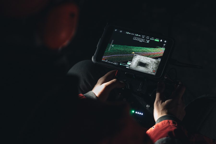
A 3D Live Map on Flyability’s Elios 3 pilot tablet (live visual feed appears in the lower right)

3D Live Maps maps are made using LiDAR data and SLAM (simultaneous localization and mapping), an algorithm that allows robots to locate themselves in three-dimensional space as they move through it, and create a map of it.

Flyability’s Elios 3 indoor drone comes with a LiDAR sensor and a proprietary SLAM engine called FlyAware, allowing it to create 3D Live Maps. And these maps are opening up new use cases for heavy duty commercial operations that might otherwise be impossible due to dust.

Here’s how the Elios 3 creates 3D maps as it flies:

  • While in flight, the LiDAR sensor on the Elios 3 acts as a centimeter-accurate indoor GPS, sensing the drone’s surroundings.
  • FlyAware (Flyability’s SLAM engine) uses this data to create a 3D map of the space it’s moving through, layering on more detail as the drone gathers more data.

Elios 3 Used for Cement Plant Stockpile Measurement

Of all the industries that face issues with dust for their drone operations, cement is one of the most challenging.

dust-elios-3-visual
Picture taken by the Elios 3 inside a silo at a cement plant

Cement plants are incredibly dusty places, with all their operations inundated by different kinds of particulates made as a result of the cement production process.

In a recent mission, the Elios 3 was used at a cement plant in France to calculate the amount of a material called clinker that was stored in one of its silos.

The typical approach for these calculations was to have one of the plant’s workers climb onto a rickety platform about 80 feet in the air, in the dark of the silo, and poke a hold down into the clinker with a very long pole. Using approximate measurements from the pole, the worker would then estimate how much clinker there was in the silo.

clinker-silo-3d-live-map
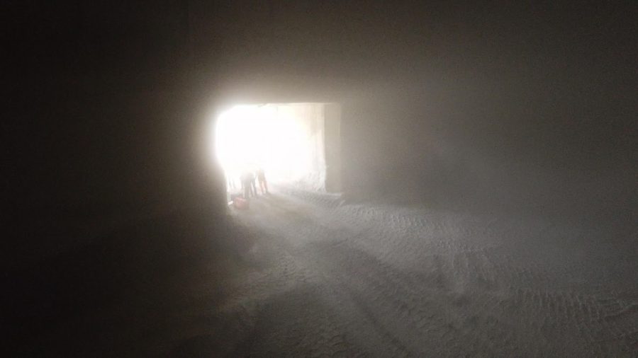
The platform workers stand on captured by the Elios 3 (3D Live Map appears in lower right)

These measurements are important to production, since clinker is an essential ingredient for making cement.

The plant’s owners wanted to see if they could improve this potentially dangerous and inexact process, so they asked Flyability to test the Elios 3 to see if it could measure the clinker using 3D mapping.

The Elios 3 was chosen for this test stockpile calculation because it could operate in the extremely dusty environment of the silo—a place where it was so dusty that the drone’s visual camera would be almost completely blind while flying.

Outcome from the Mission

The Elios 3 was able to operate well inside the silo despite the dusty conditions, and was quickly able to calculate the volume of clinker in the silo.

cement-dust-3d-live-map
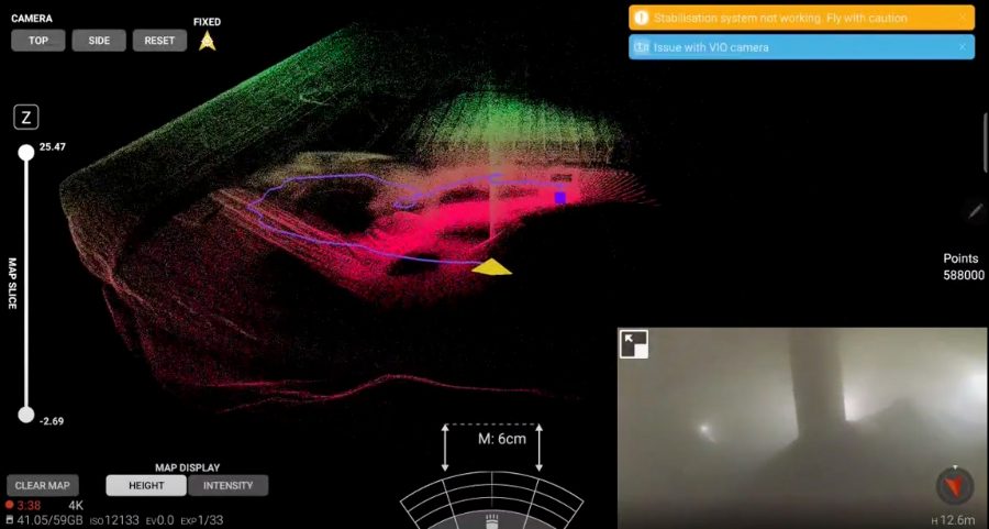
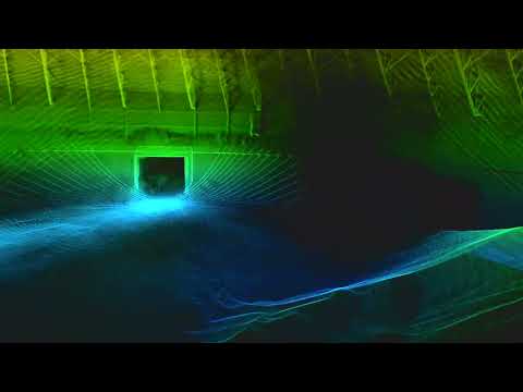
3D Live Map inside the silo (poor visibility shown in visual feed)

In ten minutes, the Elios 3 collected all the data needed to make the stockpile calculation. It took another 20 minutes of post-processing with the software GeoSLAM Connect to produce the stockpile measurement that the cement plant needed, making for a total of 30 minutes required for the effort.

This image shows the output from the stockpile measurement:

cement-plant-clinker-stockpile-measurement

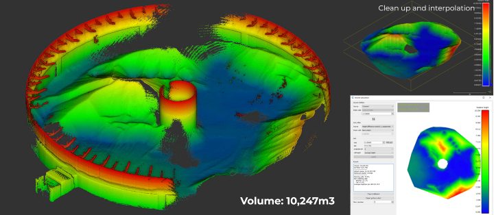
In addition to being safer and quicker than the manual method typically used to measure the clinker, which required a worker to stand on a platform and poke a stick into the material, the measurement was also much more accurate.

Check out this 3D fly through of the clinker silo made with LiDAR data collected by the Elios 3:

Major Cement Company Improves Stockpile Measurement with Elios 3

Five years ago, flying in highly dusty environments may have simply seemed impossible. But today, thanks to the continued advances in drone technology, it’s not only possible, it can be done by drone pilots with relatively limited experience.

As drone technology develops, the ability to visualize spaces using LiDAR data while the drone is in flight will only continue to improve, opening up more and more places where drones can provide value in industrial scenarios.

Join a global community of

100,000+

drone enthusiasts.

Subscribe

Drone Pilot's Guide to DJI Mini 4 Pro

  • Navigate the DJI Fly app and flight modes with ease
  • Adjust camera and safety settings for better control
  • Understand intelligent flight features and how to use them
  • Avoid common beginner mistakes
  • Get the most out of your drone—without the guesswork

Drone Pilot's Guide to DJI Air 3S

  • Navigate the DJI Fly app and flight modes with ease
  • Adjust camera and safety settings for better control
  • Understand intelligent flight features and how to use them
  • Avoid common beginner mistakes
  • Get the most out of your drone—without the guesswork

Hands-On Flight Training

$295

400+ 5-Star Reviews

  • Team up with a knowledgeable, friendly instructor at a convenient outdoor spot — like a park or athletic field
  • Fly a top-rated drone provided for you, or bring your own to get personalized guidance
  • Spend most of your time in the air with hands-on practice — learning about composition, camera angles and cinematic motion
  • Explore the DJI Fly app and learn how to use camera settings like ISO, shutter speed and aperture
  • Unlock the power of Intelligent Flight Modes to fly smoother, smarter, and with less stress
  • Get access to our Aerial Photo & Video online course with additional exercises and pro-level editing workflows – using Snapseed, Photopea, Adobe Lightroom, DJI LightCut, and Premiere Pro

Aerial Photo & Video for Drone Pilots

$179

3,500+ 5-Star Reviews

  • How to dial in the right camera settings like ISO, shutter speed, and aperture
  • The best angles & altitudes for different types of shots (real estate, landscapes, cityscapes, and more)
  • The secret to cinematic drone motion that makes your footage feel like a Hollywood movie
  • How to enhance colors, remove distractions, and sharpen details – even in tricky lighting
  • Pro-level editing workflows – whether you’re using Lightroom, free tools, or mobile apps

The Recreational UAS Safety Test

Free

150+ 5-Star Reviews

  • Required for U.S. recreational flyers of drones
  • Launched June 2021 by the FAA
  • Takes about 30 minutes to complete
  • No prior drone knowledge needed
  • Test allows unlimited attempts to pass

Drone Mapping Essentials Workshop

$799

3,500+ 5-Star Reviews

  • Expert instruction from expert drone pilots with over 100 hours of flying experience
  • Hands-on training of live data capture and how to process deliverables for your clients
  • Peer-to-peer networking with other professional drone pilots in the mapping industry
  • Free access to the online course, Drone Mapping Essentials

Flight Skills for Drone Pilots

$99

75+ 5-Star Reviews

  • 16 engaging video lectures with key takeaways
  • Action items with concrete steps so you put into practice what you learn
  • Pre-flight checklists to help you plan your flights
  • Resource links to websites, products and software for further learning and discovery

Drone Business & Mapping Bundle

$617 $397

3,500+ 5-Star Reviews

  • Drone Pilot Ground School
    1. 1:1 support with a Part 107 exam success coach
    2. Study 100% online at your own pace
    3. Unlimited practice exams with 400+ real FAA test questions
  • Drone Mapping Essentials
    1. 100+ instructional videos focused on real-world application with high-quality videos
    2. Downloadable resources like data capture checklists to utilize in your missions
    3. Monthly live instruction with course instructor, Dylan Gorman, to go deeper on topics where you need more clarification
  • The Drone Business Blueprint
    1. Expert instruction from industry veteran, Eno Umoh, who brings real-world experience in building successful drone businesses.
    2. 14 Comprehensive modules covering everything from business setup to marketing strategies
    3. 30 Downloadable resources to apply your learning immediately

Hands-On Flight Training

$295

400+ 5-Star Reviews

  • 45-60 minutes of hands-on flying time to master orientation and flight maneuvers tailored to your skill level
  • Learn how to handle obstacles such as lost GPS, low battery charge or emergencies
  • Practice flying under various intelligent flight modes
  • Ask questions about regulations, software, flight operations management, and more

The Drone Business Blueprint

$119

3,500+ 5-Star Reviews

  • Expert instruction from industry veteran, Eno Umoh, who brings real-world experience in building successful drone businesses.
  • 14 Comprehensive modules covering everything from business setup to marketing strategies
  • 30 Downloadable resources to apply your learning immediately
  • AI tools and techniques to boost productivity and streamline your operations

Commercial Drone Business Bundle

$418 $334

4,000+ 5-Star Reviews

  • Drone Pilot Ground School
    1. 1:1 support with a Part 107 exam success coach
    2. Study 100% online at your own pace
    3. Unlimited practice exams with 400+ real FAA test questions
  • The Drone Business Blueprint
    1. Expert instruction from industry veteran, Eno Umoh, who brings real-world experience in building successful drone businesses.
    2. 14 Comprehensive modules covering everything from business setup to marketing strategies
    3. 30 Downloadable resources to apply your learning immediately

Drone Mapping Essentials

$199

3,500+ 5-Star Reviews

  • 100+ instructional videos focused on real-world application with high-quality videos
  • Downloadable resources like data capture checklists to utilize in your missions
  • Quizzes to test your knowledge so you can succeed in the field
  • Monthly live instruction with course instructor, Dylan Gorman, to go deeper on topics where you need more clarification

Drone Pilot Pro Bundle

$713 $499

3,500+ 5-Star Reviews

  • Drone Pilot Ground School
    1. 1:1 support with a Part 107 exam success coach
    2. Study 100% online at your own pace
    3. Unlimited practice exams with 400+ real FAA test questions
  • Drone Pilot Skill Builder
    1. 16 engaging video lectures with key takeaways
    2. Action items with concrete steps so you put into practice what you learn
  • Hands-On Flight Training
    1. 45-60 minutes of hands-on flying time to master orientation and flight maneuvers tailored to your skill level

Drone Pilot Ground School

$299

4,000+ 5-Star Reviews

  • 1:1 support with a Part 107 exam success coach
  • Study 100% online at your own pace
  • Unlimited practice exams with 400+ real FAA test questions
  • Personalized study plans, virtual flashcards, and 12-page cram sheet
  • Weekly webinars on acing the Part 107 exam and monthly webinars to elevate your journey post-certification