

Chula Vista Police Department Partners with AirData UAV to Enhance Drone Program Transparency
BY Zacc Dukowitz
7 October 2021The Chula Vista Police Department recently announced that it will be using AirData UAV to bring greater public transparency to its drone operations.
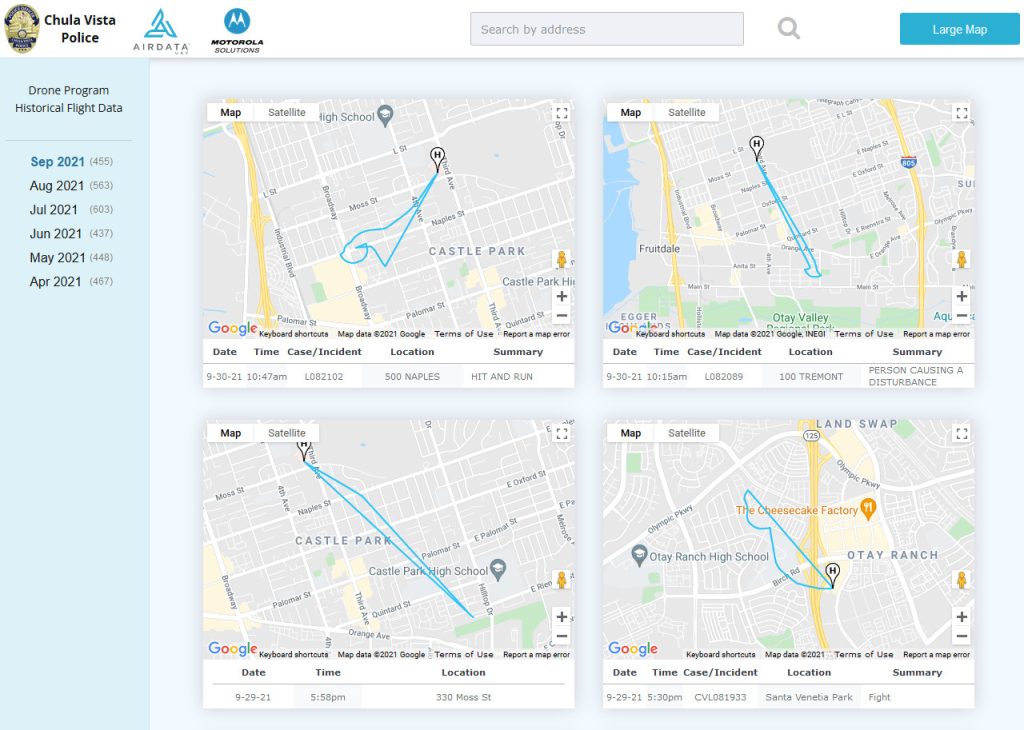
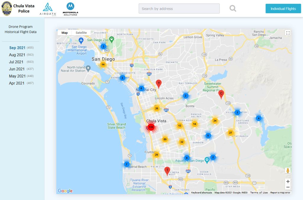
AirData UAV is a drone flight operations platform that lets drone pilots store and analyze data from their flights. Through the partnership, residents in Chula Vista will now be able to “view and understand the exact location, flight path, and purpose behind each police drone deployment.”

Every drone mission the police department conducts will be tracked and recorded, allowing transparency for any stakeholder that wants to see how the police are using drones.
Transparency and accountability are key components in the success of our drone program which has been an invaluable tool in maintaining the safety of our officers and the public. We pride ourselves on ensuring the public has access to our drone flight information in upholding the trust of our community.
– Chief Roxana Kennedy, Chula Vista Police Department
The high degree of transparency the AirData UAV platform provides could go a long way toward alleviating the privacy concerns that many have about law enforcement drone programs, and could provide a model for other police departments that are considering launching their own drone programs.
See the live data provided by AirData UAV here.
How AirData UAV Supports Public Safety Drone Programs
With the AirData UAV integration officers from Chula Vista PD can fly their drone missions without worrying about tracking their data, since the AirData platform does the tracking for them.
AirData UAV helps the police by automatically tracking:
- Maintenance timelines and related notifications
- Reporting
- Flight logs
- Federal compliance
AirData UAV processes a whopping 20,000 flights a day. According to information it provided, the platform is the largest online drone fleet data management platform, with 210,000 users and 20 million flights uploaded to date.
And the platform isn’t just a flight ops management tool for logging flights. In addition to its flight logbook, it also provides comprehensive safety data analysis and crash prevention, including advanced maintenance tracking.
We are excited to work closely with Chula Vista to provide full transparency of the police department flights to the community. Chula Vista offers its residents an open AirData-driven web page, enabling the public to be well informed of drone-related law enforcement activity.
– Eran Steiner, Founder and CEO of AirData UAV
An additional feature AirData UAV offers is real-time flight streaming, which could be useful for police departments that want to deploy drones to the scenes of 911 calls.
Here are some examples of the kinds of data Chula Vista residents can access using AirData UAV:
Chula Vista PD’s Drone as First Responder Program
The adoption of AirData UAV for community transparency is part of the Chula Vista Police Department’s Drone as First Responder Program, which automatically deploys drones to the locations from which emergency calls have been made, providing law enforcement with aerial data of unfolding events before they arrive.
Two key benefits to having eyes on a scene prior to the arrival of officers are that suspects can be located and followed, and that officers can have a sense of what to expect on the scene, so they won’t be ambushed or surprised.

Earlier this year, the Chula Vista PD were able to capture a shooting suspect using a drone. The drone arrived at the scene of the shooting ahead of officers, and it was able to follow the suspect as he fled.
The story is a perfect example of the effectiveness of the program.
A delay of just a few minutes would have given the suspect time to get away, and also might have exposed the officers to a possible ambush if he had decided to hide and wait for them to arrive.
The Chula Vista Police Department has been on the forefront of drones in public safety for several years.
It was the first police department in the U.S. to receive a COA to fly Beyond Visual Line of Sight (BVLOS), and its Drone as First Responder program uses technology developed specifically for Chula Vista.
It has also been a leader in transparency and accountability around the use of drones.
Although the AirData UAV partnership will provide an unprecedented level of transparency to its operations, the Chula Vista PD has been sharing data about its flights in monthly reporting since late 2020.
Now, with the new partnership, this data will be provided more quickly and it will be much more comprehensive.


