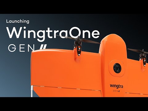
After 6 Years of Testing Wingtra Launches the WingtraOne Gen II, A Drone Made Just for Large-Scale City Mapping

BY Zacc Dukowitz
12 August 2021

Over the last several years Wingtra has made a name for itself as the go-to commercial drone for surveying and mapping.

But it’s not sitting still.

The Swiss-based startup just launched the WingtraOne Gen II, the next generation of its professional mapping drone.

wingtra-one-gen-ii

Made for large-scale city mapping, the new drone has the potential not only to improve the way big projects are planned, but also to open up even more industrial use cases for 3D models.

The new drone comes with a new Sony camera made specifically for mapping buildings and is supported through partnerships with geospatial software giants Bentley Systems and Esri.

In short, Wingtra already had one of the best drone mapping solutions on the market—and now it’s released an even better one.

Specs and Details for the WingtraOne Gen II

Wondering what makes the WingtraOne Gen II special?

Here are the highlights:

  • Oblique camera. The Oblique Sony a6100 supports highly detailed 3D reconstruction by collecting extra data for mapping tricky vertical walls (just think of all the walls you’ll find in a city and you’ll understand the value).
  • PPK for high level of accuracy. The Gen II comes with a built-in multi-frequency L1/L2 PPK (Post Processed Kinematic ) GNSS receiver, providing centimeter-level accuracy for 3D modeling.
  • Multispectral payloads. The Gen II can carry the RedEdge sensor and the Altum sensor from MicaSense. Both sensors support the capture of 5-band multispectral data and the Altum also supports thermal data collection.
  • Predictive maintenance. Intelligent algorithms in the Gen II continuously analyze all critical flight components before and during the flight.
  • Smart notifications. Automatic notifications from the above alert you to maintenance issues before they become critical.
  • Remote ID ready. The Gen II comes with a WiFi module that ensures compliance with forthcoming Remote ID requirements in the U.S.
  • Landing accuracy. A new navigation and heading unit (NHU) improves GNSS accuracy and boosts the landing accuracy of the Gen II to about six feet.

mapping-zurich-wingtra

Of course, visual data collection is just the first step for creating great 3D models.

In addition to all these new features and improvements to help surveyors capture high quality data, Wingtra has formed key partnerships with Bentley Systems and Esri, both of which are huge players in geospatial software.

Through the partnership, users can process the visual data they collect with the Gen II in the cloud, leveraging Esri’s Site Scan for ArcGIS and Bentley’s ContextCapture to quickly create highly accurate 3D models.

Oblique Camera Data + High Quality Software = Step Change in 3D Modeling

One challenge surveyors face when constructing 3D models of buildings is that vertical walls require a high level of detail in order to be rendered accurately.

The Oblique Sony a6100 was created to solve this problem. It has a very wide angle field of view, from the front to the sides, and presents a powerful way to collect data for mapping cities.

oblique-sony-camera
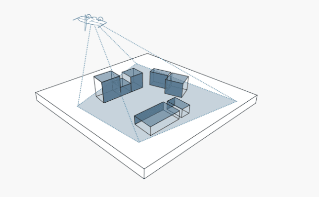
An illustration of the Oblique Sony a6100’s wide angle view

To demonstrate the power of the WingtraOne Gen II and its oblique camera capabilities, Wingtra used it to create a detailed map of the city of Zurich.

The flight time needed to make the map was just six hours—a very short period given the scope of the project.

Zurich digital twin - WingtraOne GEN II and Oblique Sony a6100

Read the case study to learn more about how Wingtra’s project in Zurich.

Big Focus on Reliability

While the PPK receiver, the new oblique camera, and the two big software partnerships Wingtra has made are all impressive, one of the biggest features the company offers in its new drone is something more simple: reliability.

Wingtra can make the claim to reliability because it has been around for over six years now, which means it’s had the chance to field test its hardware over and over.

With GEN II, we’re marking a key point in commercial drone evolution by providing you with a reliable workhorse that you can count on over every flight.

– Julian Surber, Product Manager at Wingtra

To make this concrete, Wingtra has shared these numbers highlighting the amount of work and testing that went into creating the WingtraOne Gen II:

  • 100,000+ flights
  • 6 years of testing and improvements
  • 40+ software releases

And Wingtra is right to highlight all of this experience.

While some drone startups make claims about what they’ll be able to do one day, Wingtra has been in the field for years, helping professionals conduct surveys and create 3D maps.

Learn more about the WingtraOne Gen II in this video:

WingtraOne GEN II: The next level of drone worksite reliability and mapping versatility

Join a global community of

100,000+

drone enthusiasts.

Subscribe

Drone Pilot's Guide to DJI Mini 4 Pro

  • Navigate the DJI Fly app and flight modes with ease
  • Adjust camera and safety settings for better control
  • Understand intelligent flight features and how to use them
  • Avoid common beginner mistakes
  • Get the most out of your drone—without the guesswork

Drone Pilot's Guide to DJI Air 3S

  • Navigate the DJI Fly app and flight modes with ease
  • Adjust camera and safety settings for better control
  • Understand intelligent flight features and how to use them
  • Avoid common beginner mistakes
  • Get the most out of your drone—without the guesswork

Hands-On Flight Training

$295

400+ 5-Star Reviews

  • Team up with a knowledgeable, friendly instructor at a convenient outdoor spot — like a park or athletic field
  • Fly a top-rated drone provided for you, or bring your own to get personalized guidance
  • Spend most of your time in the air with hands-on practice — learning about composition, camera angles and cinematic motion
  • Explore the DJI Fly app and learn how to use camera settings like ISO, shutter speed and aperture
  • Unlock the power of Intelligent Flight Modes to fly smoother, smarter, and with less stress
  • Get access to our Aerial Photo & Video online course with additional exercises and pro-level editing workflows – using Snapseed, Photopea, Adobe Lightroom, DJI LightCut, and Premiere Pro

Aerial Photo & Video for Drone Pilots

$179

3,500+ 5-Star Reviews

  • How to dial in the right camera settings like ISO, shutter speed, and aperture
  • The best angles & altitudes for different types of shots (real estate, landscapes, cityscapes, and more)
  • The secret to cinematic drone motion that makes your footage feel like a Hollywood movie
  • How to enhance colors, remove distractions, and sharpen details – even in tricky lighting
  • Pro-level editing workflows – whether you’re using Lightroom, free tools, or mobile apps

The Recreational UAS Safety Test

Free

150+ 5-Star Reviews

  • Required for U.S. recreational flyers of drones
  • Launched June 2021 by the FAA
  • Takes about 30 minutes to complete
  • No prior drone knowledge needed
  • Test allows unlimited attempts to pass

Drone Mapping Essentials Workshop

$799

3,500+ 5-Star Reviews

  • Expert instruction from expert drone pilots with over 100 hours of flying experience
  • Hands-on training of live data capture and how to process deliverables for your clients
  • Peer-to-peer networking with other professional drone pilots in the mapping industry
  • Free access to the online course, Drone Mapping Essentials

Flight Skills for Drone Pilots

$99

75+ 5-Star Reviews

  • 16 engaging video lectures with key takeaways
  • Action items with concrete steps so you put into practice what you learn
  • Pre-flight checklists to help you plan your flights
  • Resource links to websites, products and software for further learning and discovery

Drone Business & Mapping Bundle

$617 $397

3,500+ 5-Star Reviews

  • Drone Pilot Ground School
    1. 1:1 support with a Part 107 exam success coach
    2. Study 100% online at your own pace
    3. Unlimited practice exams with 400+ real FAA test questions
  • Drone Mapping Essentials
    1. 100+ instructional videos focused on real-world application with high-quality videos
    2. Downloadable resources like data capture checklists to utilize in your missions
    3. Monthly live instruction with course instructor, Dylan Gorman, to go deeper on topics where you need more clarification
  • The Drone Business Blueprint
    1. Expert instruction from industry veteran, Eno Umoh, who brings real-world experience in building successful drone businesses.
    2. 14 Comprehensive modules covering everything from business setup to marketing strategies
    3. 30 Downloadable resources to apply your learning immediately

Hands-On Flight Training

$295

400+ 5-Star Reviews

  • 45-60 minutes of hands-on flying time to master orientation and flight maneuvers tailored to your skill level
  • Learn how to handle obstacles such as lost GPS, low battery charge or emergencies
  • Practice flying under various intelligent flight modes
  • Ask questions about regulations, software, flight operations management, and more

The Drone Business Blueprint

$119

3,500+ 5-Star Reviews

  • Expert instruction from industry veteran, Eno Umoh, who brings real-world experience in building successful drone businesses.
  • 14 Comprehensive modules covering everything from business setup to marketing strategies
  • 30 Downloadable resources to apply your learning immediately
  • AI tools and techniques to boost productivity and streamline your operations

Commercial Drone Business Bundle

$418 $334

4,000+ 5-Star Reviews

  • Drone Pilot Ground School
    1. 1:1 support with a Part 107 exam success coach
    2. Study 100% online at your own pace
    3. Unlimited practice exams with 400+ real FAA test questions
  • The Drone Business Blueprint
    1. Expert instruction from industry veteran, Eno Umoh, who brings real-world experience in building successful drone businesses.
    2. 14 Comprehensive modules covering everything from business setup to marketing strategies
    3. 30 Downloadable resources to apply your learning immediately

Drone Mapping Essentials

$199

3,500+ 5-Star Reviews

  • 100+ instructional videos focused on real-world application with high-quality videos
  • Downloadable resources like data capture checklists to utilize in your missions
  • Quizzes to test your knowledge so you can succeed in the field
  • Monthly live instruction with course instructor, Dylan Gorman, to go deeper on topics where you need more clarification

Drone Pilot Pro Bundle

$713 $499

3,500+ 5-Star Reviews

  • Drone Pilot Ground School
    1. 1:1 support with a Part 107 exam success coach
    2. Study 100% online at your own pace
    3. Unlimited practice exams with 400+ real FAA test questions
  • Drone Pilot Skill Builder
    1. 16 engaging video lectures with key takeaways
    2. Action items with concrete steps so you put into practice what you learn
  • Hands-On Flight Training
    1. 45-60 minutes of hands-on flying time to master orientation and flight maneuvers tailored to your skill level

Drone Pilot Ground School

$299

4,000+ 5-Star Reviews

  • 1:1 support with a Part 107 exam success coach
  • Study 100% online at your own pace
  • Unlimited practice exams with 400+ real FAA test questions
  • Personalized study plans, virtual flashcards, and 12-page cram sheet
  • Weekly webinars on acing the Part 107 exam and monthly webinars to elevate your journey post-certification