

Is Your State Drone Ready? New Report Reveals the Best and Worst States for Commercial Drone Operations
BY Zacc Dukowitz
10 March 2021What’s the best state for commercial drone operators? North Dakota.
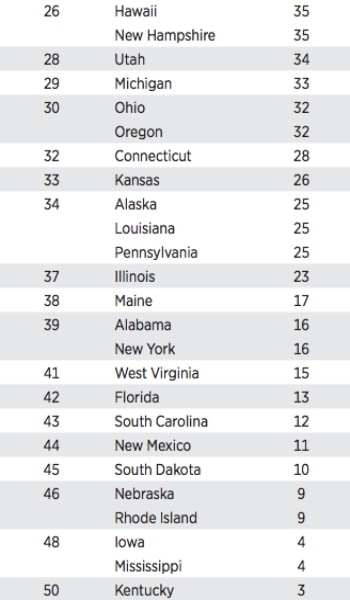
What’s the worst? Kentucky.
These answers come from a recent report created by the Mercatus Center at George Mason University, which seeks to answer the question: “Which states are prepared for the drone industry?” (The new report is a 2.0 version of a report released last March.)
To create the report, researchers at the Mercatus Center looked at drone laws in all 50 states in the U.S., ranking them in order from best to worst. The results are provided in an interactive map that allows you to click through to a specific page for each state.
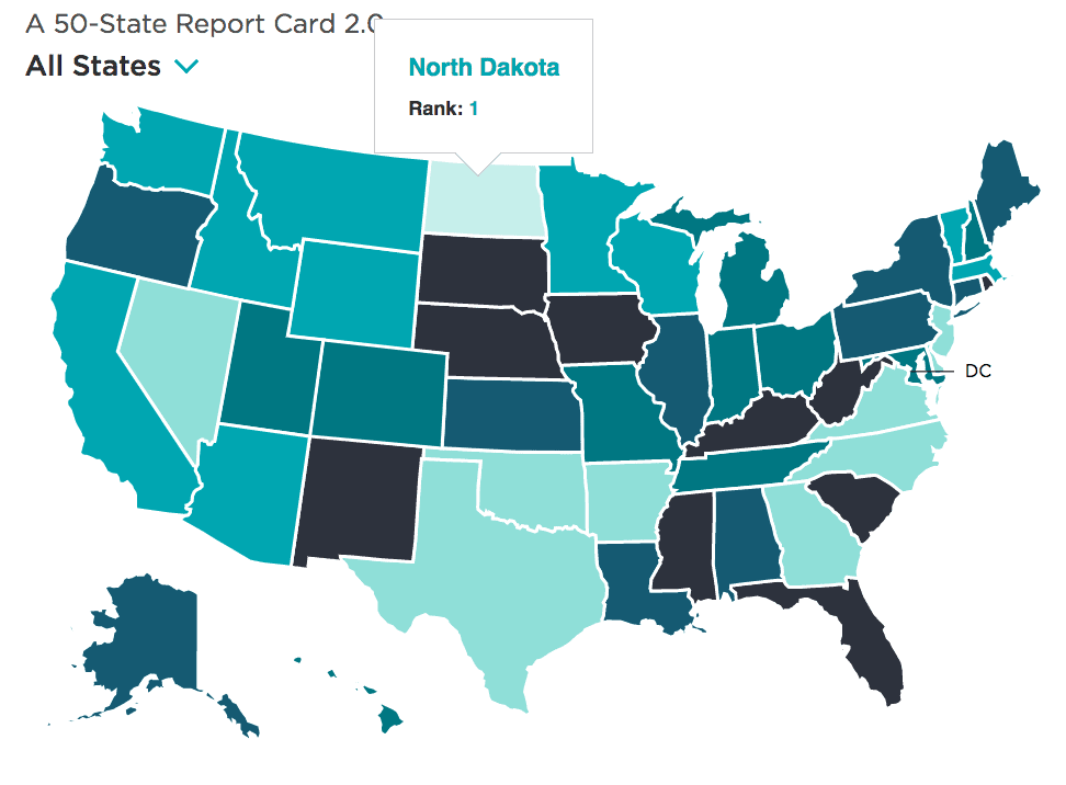
Image credit: Mercatus Center
By clicking on a state in the map you can see the individual report for the state, including specific criteria that help or hinder the state when it comes to drone readiness:
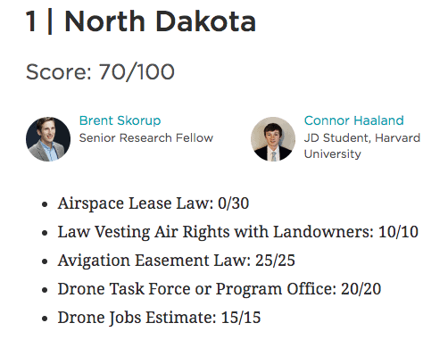
Image credit: Mercatus Center
Scanning the map and clicking into different states, you start to see how some states—like North Dakota—have created legislation to encourage and support commercial drone operations, and proactively invested in creating an infrastructure to support them.
You also see that some states have been passive and taken no real legislative action to support drone adoption.
And then there states that have actively blocked drone readiness, creating laws to hinder or prevent their use.
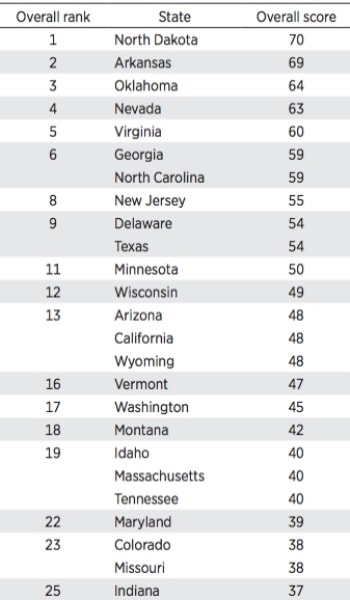
Read on to learn how researchers ranked states for their drone readiness, or browse the rankings from best to worst below:
Check out the full interactive map on the Mercatus Center website.
The Importance of Drone Highways
Drone highways (aerial corridors directly above public roads) were a key factor for Mercatus Center researchers in evaluating the drone readiness of states.
Image credit: Mercatus Center
Instead of waiting for federal legislation to catch up to present needs, the researchers advocate for states to encourage safe drone adoption by creating the infrastructure needed to support it.
In the Center’s full report researchers go beyond evaluating states, and make a strong recommendation in favor of drone highways as an important way for states to support the safe integration of commercial drone operations, such as drone delivery, into their airspace.
Here is how they phrase their recommendation:
State authorities should prepare to have more involvement in drone operations than they historically had in aviation. States and cities have police powers over land use and zoning, and low-altitude airspace—where many drones will fly—is inseparable from the land beneath it. For practical and legal reasons, then, state and city authorities will play a key role in demarcating drone highways as well as in creating time, place, and manner restrictions such as time-of-day rules, noise maximums, and privacy protectionsEach of these five points was given a certain weight, so that the states could be evenly compared based solely on the criteria being considered.
How Were States Ranked?
In ranking states for drone readiness, Mercatus Center researchers looked at “their preparedness for drones and drone highways.”
To make these two interconnected areas of consideration concrete, researchers used a rubric that looks at five different areas of a state’s drone laws, with each one assigned a number of points according to how important it is to a state’s overall drone readiness.
Here are the five areas:
1. Airspace lease law (30 points)
Drone highways must be demarcated by regulators and safely separated from airports, homes, schools, and other sensitive locations. Leasing airspace above public property would accelerate drone services because creating flight paths over backyards and private lands raises issues about the taking of private property.
2. Law vesting air rights with landowners (10 points)
This clarifies that the state is exercising its police powers and defining property rights—and puts drone operators and residents on notice about the extent of those rights. Where state or local authorities own public rights-of-way, air rights laws recognize their property interest in the aerial corridors above public roads.
3. Avigation easement law (25 points)
This allows drones to operate as long as they are high enough not to bother landowners and passersby. If the state or municipality does not own aerial corridors above public roads, drones can still generally access the aerial easements if state officials demarcate drone highways above public roads.
4. Drone task force or program office (20 points)
These bodies help anticipate (and address) issues such as zoning rules, noise limits, time-of-day restrictions, insurance, and privacy for private dwellings.
5. Drone jobs estimate (15 points)
The number of drone jobs per 100,000 residents is a proxy for soft factors (e.g., a college offering drone programs or workers in the aerospace industry) that can position states for future jobs and services growth.
The Mercatus Center’s Futuristic Perspective
Looking at the list, you see that preparedness for drone highways dominates the rubric. The first three areas of consideration all pertain to providing some kind of drone corridor or aerial easement for drone operations, making up 65 out of a total possible score of 100 points.

The emphasis on drone highways, which have just started to be tested and rolled out in the last few years, reveals just how futuristic the rubric is.
By this, we mean that it lays out criteria for what the researchers think should be in place for drone readiness, not for what already is commonly in place in most states.
This futuristic perspective is made clear by the relatively low score of the top state. While North Dakota is #1 on the list, the state still only has a score of 70, leaving lots of room for growth and improvement.
And this is a good thing.
A big takeaway from the report is that states can have a significant role in how commercial drone operations take place, and that there are a lot of opportunities for states to insert themselves in the drone adoption already taking place there.
As the report points out, by adopting legislation that enables the creation of drone highways and other related initiatives, such as establishing a statewide drone task force (see #4 above), states can have a positive, proactive role in how their airspace is used—even though the federal government controls the airspace itself.
This observation belies the position of those who want to cede control of the airspace to local authorities, some of whom want to close the skies to commercial drone operations altogether.
An extreme example of this perspective can be found in the Drone Integration and Zoning Act recently proposed by Senator Mike Lee (R-UT), a bill that would give local authorities full legislative control over the airspace up to 200 feet.
If enacted, such a law could turn the National Airspace into a chaotic patchwork of rules, making commercial drone operations almost impossible, with pilots having to be aware of every rule change from one county, or even one city, to the next.
But the Mercatus Center’s report proposes a different solution for incorporating local interests into drone adoption: instead of creating federal laws to radically change how the skies are regulated, create state ones that will foster growth and innovation in how those skies are used.
Did you find the Mercatus Center’s rankings for drone ready states useful? Share your thoughts in this thread on the UAV Coach community forum.


