Drone LiDAR Finds Aboriginal Rock Shelters in Australia

BY Zacc Dukowitz
30 October 2026

Researchers in Australia recently identified three previously unregistered Aboriginal rock shelters with help from a DJI M350 carrying a LiDAR sensor.

The shelters were discovered west of Sydney, in the Blue Mountains.

All three contained stone artifacts. One also contained a rock-art panel with two red hand stencils.

In the same drone survey, the researchers also confirmed the locations of six shelters that were already known, pinning them down with far more accurate coordinates than those listed in the state’s official heritage register.

The project comes from archaeologists at the University of Sydney and the Australian Museum, working with Dharug custodians through the Dharug Custodian Aboriginal Corporation.

New drone digital archaeology uncovers ancient sites in Australia

How LiDAR Finds Shelters Hidden Under Tree Cover

LiDAR (Light Detection and Ranging) fires rapid laser pulses at the ground and times how long each one takes to bounce back, similar to how sonar uses sound waves.

Millions of these measurements add up to a detailed 3D map of the terrain.

The reason drone LiDAR is so powerful for archaeology is because it can see through the canopy and measure the terrain below.

A regular photo of the Blue Mountains mostly shows the tops of trees. But laser pulses can slip through gaps in the leaves and hit the ground, collecting data that allows software to strip away the vegetation and reveal the shape of the rock underneath—including the overhangs and cliff lines where shelters form.

Being able to collect this data from the air is incredibly useful.

While over 200 rock shelters with cultural and archaeological material have been recorded in the Blue Mountains, researchers estimate only about 10% of the region has been surveyed, largely because the terrain is so hard to cover on foot.

Drone LiDAR can help change that. And these new discoveries are proof that it works.

From Laser Data to Red Hand Stencils

On these missions, Dr. Jacob Bongers, the study’s lead author, flew a DJI M350 carrying a YellowScan Explorer V2 LiDAR sensor.
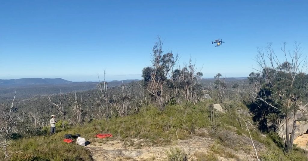
LiDAR-equipped drone surveying forested sandstone terrain for possible rock shelters

The team combined that high-resolution drone data with lower-resolution LiDAR the NSW government had already collected from aircraft, then analyzed both to flag likely shelter locations.

Once the drone data produced candidate sites, Dr. Amy Mosig Way led teams of students and volunteers into the bush to check each location and see whether the shelters held cultural material.

Wayne Brennan and Erin Wilkins of the Dharug Custodian Aboriginal Corporation then led the recording of rock art at the confirmed sites.

“This work highlights the importance of listening, learning and working together,” Brennan said.

Why You Won’t See the Exact Locations

The Dharug community asked the authors not to publish site coordinates or photos of the rock art and stone artifacts, and the authors agreed.

The researchers were also upfront about limits.

The method was tuned for Blue Mountains sandstone, so other regions would need their own calibration. The team didn’t report a false-positive count, and it didn’t survey areas where the analysis flagged nothing.

But they say the approach could help Aboriginal communities, archaeologists, and heritage managers find and protect cultural sites more efficiently across Australia.

Join a global community of

100,000+

drone enthusiasts.

Subscribe

Drone Pilot's Guide to DJI Mini 4 Pro

  • Navigate the DJI Fly app and flight modes with ease
  • Adjust camera and safety settings for better control
  • Understand intelligent flight features and how to use them
  • Avoid common beginner mistakes
  • Get the most out of your drone—without the guesswork

Drone Pilot's Guide to DJI Air 3S

  • Navigate the DJI Fly app and flight modes with ease
  • Adjust camera and safety settings for better control
  • Understand intelligent flight features and how to use them
  • Avoid common beginner mistakes
  • Get the most out of your drone—without the guesswork

Hands-On Flight Training

$295

400+ 5-Star Reviews

  • Team up with a knowledgeable, friendly instructor at a convenient outdoor spot — like a park or athletic field
  • Fly a top-rated drone provided for you, or bring your own to get personalized guidance
  • Spend most of your time in the air with hands-on practice — learning about composition, camera angles and cinematic motion
  • Explore the DJI Fly app and learn how to use camera settings like ISO, shutter speed and aperture
  • Unlock the power of Intelligent Flight Modes to fly smoother, smarter, and with less stress
  • Get access to our Aerial Photo & Video online course with additional exercises and pro-level editing workflows – using Snapseed, Photopea, Adobe Lightroom, DJI LightCut, and Premiere Pro

Aerial Photo & Video for Drone Pilots

$179

3,500+ 5-Star Reviews

  • How to dial in the right camera settings like ISO, shutter speed, and aperture
  • The best angles & altitudes for different types of shots (real estate, landscapes, cityscapes, and more)
  • The secret to cinematic drone motion that makes your footage feel like a Hollywood movie
  • How to enhance colors, remove distractions, and sharpen details – even in tricky lighting
  • Pro-level editing workflows – whether you’re using Lightroom, free tools, or mobile apps

The Recreational UAS Safety Test

Free

150+ 5-Star Reviews

  • Required for U.S. recreational flyers of drones
  • Launched June 2021 by the FAA
  • Takes about 30 minutes to complete
  • No prior drone knowledge needed
  • Test allows unlimited attempts to pass

Drone Mapping Essentials Workshop

$799

3,500+ 5-Star Reviews

  • Expert instruction from expert drone pilots with over 100 hours of flying experience
  • Hands-on training of live data capture and how to process deliverables for your clients
  • Peer-to-peer networking with other professional drone pilots in the mapping industry
  • Free access to the online course, Drone Mapping Essentials

Flight Skills for Drone Pilots

$99

75+ 5-Star Reviews

  • 16 engaging video lectures with key takeaways
  • Action items with concrete steps so you put into practice what you learn
  • Pre-flight checklists to help you plan your flights
  • Resource links to websites, products and software for further learning and discovery

Drone Business & Mapping Bundle

$617 $397

3,500+ 5-Star Reviews

  • Drone Pilot Ground School
    1. 1:1 support with a Part 107 exam success coach
    2. Study 100% online at your own pace
    3. Unlimited practice exams with 400+ real FAA test questions
  • Drone Mapping Essentials
    1. 100+ instructional videos focused on real-world application with high-quality videos
    2. Downloadable resources like data capture checklists to utilize in your missions
    3. Monthly live instruction with course instructor, Dylan Gorman, to go deeper on topics where you need more clarification
  • The Drone Business Blueprint
    1. Expert instruction from industry veteran, Eno Umoh, who brings real-world experience in building successful drone businesses.
    2. 14 Comprehensive modules covering everything from business setup to marketing strategies
    3. 30 Downloadable resources to apply your learning immediately

Hands-On Flight Training

$295

400+ 5-Star Reviews

  • 45-60 minutes of hands-on flying time to master orientation and flight maneuvers tailored to your skill level
  • Learn how to handle obstacles such as lost GPS, low battery charge or emergencies
  • Practice flying under various intelligent flight modes
  • Ask questions about regulations, software, flight operations management, and more

Commercial Drone Business Bundle

$418 $334

4,000+ 5-Star Reviews

  • Drone Pilot Ground School
    1. 1:1 support with a Part 107 exam success coach
    2. Study 100% online at your own pace
    3. Unlimited practice exams with 400+ real FAA test questions
  • The Drone Business Blueprint
    1. Expert instruction from industry veteran, Eno Umoh, who brings real-world experience in building successful drone businesses.
    2. 14 Comprehensive modules covering everything from business setup to marketing strategies
    3. 30 Downloadable resources to apply your learning immediately

Drone Mapping Essentials

$199

3,500+ 5-Star Reviews

  • 100+ instructional videos focused on real-world application with high-quality videos
  • Downloadable resources like data capture checklists to utilize in your missions
  • Quizzes to test your knowledge so you can succeed in the field
  • Monthly live instruction with course instructor, Dylan Gorman, to go deeper on topics where you need more clarification

The Drone Business Blueprint

$119

3,500+ 5-Star Reviews

  • Expert instruction from industry veteran, Eno Umoh, who brings real-world experience in building successful drone businesses.
  • 14 Comprehensive modules covering everything from business setup to marketing strategies
  • 30 Downloadable resources to apply your learning immediately
  • AI tools and techniques to boost productivity and streamline your operations

Drone Pilot Pro Bundle

$713 $499

3,500+ 5-Star Reviews

  • Drone Pilot Ground School
    1. 1:1 support with a Part 107 exam success coach
    2. Study 100% online at your own pace
    3. Unlimited practice exams with 400+ real FAA test questions
  • Drone Pilot Skill Builder
    1. 16 engaging video lectures with key takeaways
    2. Action items with concrete steps so you put into practice what you learn
  • Hands-On Flight Training
    1. 45-60 minutes of hands-on flying time to master orientation and flight maneuvers tailored to your skill level

Drone Pilot Ground School

$299

4,000+ 5-Star Reviews

  • 1:1 support with a Part 107 exam success coach
  • Study 100% online at your own pace
  • Unlimited practice exams with 400+ real FAA test questions
  • Personalized study plans, virtual flashcards, and 12-page cram sheet
  • Weekly webinars on acing the Part 107 exam and monthly webinars to elevate your journey post-certification