Is It Illegal to Use Your Drone to Film Your Neighbors Doing Something Illegal?

BY Zacc Dukowitz
11 October 2022

A couple in the town of Berkeley, Massachusetts is threatening to sue their neighbors for criminal harassment for shooting footage of their property with a drone.

The catch?

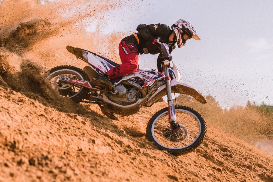
The couple had been illegally running motocross races on their property—and the drone footage was shot as evidence.

According to neighbors, including those who shot the footage, the motocross races had drawn big crowds, creating large clouds of dust, lots of noise, and making for a general nuisance in the area.

[Related read: Can You Shoot Down a Drone Over Your Property? And What Do You Do If Someone Shoots at Your Drone?]

motoccross-legal-case-drones
Image source

How It Came to This

Before neighbors shot the drone footage of the motocross races, the city had already ordered the couple to stop hosting dirt bike events.

Last year, council members in Berkeley heard testimony from Angela and Michael Ricardo, the couple that host the motocross races. The Ricardos acknowledged that they were using their land for dirt bike races and training, but denied they were running a business, saying the motocross activities were just a hobby.

Council members pointed to a YouTube video shot on the Ricardos’ land titled “Ricardo Training Facility” as proof they were in fact running a business, but the Ricardos said they hadn’t made it or approved its release.

Ricardo Training Facility

The Ricardos also said that riders on their land were allowed to make donations but weren’t charged fees. And this was the sticking point for the city council, which pointed out that any exchange of money, voluntary or not, made the dirt bike activities a business.

As a result, the council ordered Berkeley building inspector Joseph Biszko to issue a cease and desist order for the motocross races, and that’s where things landed—the Ricardos had to stop.

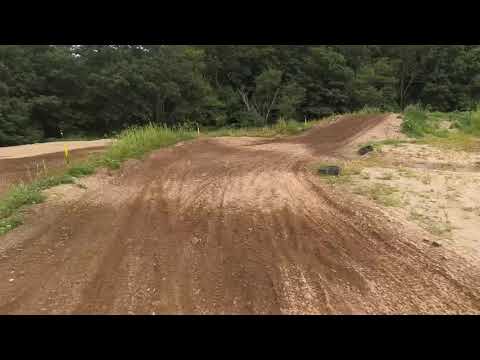
But they didn’t, and the races continued, so the couples’ neighbors used a drone to capture footage of the races to prove they were still happening.

The drone footage was then sent to the building inspector, to prove that the Ricardos hadn’t heeded the council’s directive.

When the Ricardos found out about the footage, they demanded to be given it. Biszko refused, and they called the police.

Who’s Right?

According to the Ricardos, their neighbors’ drone surveillance is part of a larger harassment effort to stop them from using their land as they want.

According to their neighbors, the Ricardos are conducting an illegal business that they have already been told to shut down, and the drone footage only serves to prove this fact.

So who’s right, from a legal standpoint?

drone-surveillance-court-cases
Image source

According to the police report created as a result of the Ricardos’ complaint, the neighbors are in the wrong. The report says that the drone videos constitute “repeated and targeted… criminal harassment” and caused the property owners to suffer “emotional stress stemming from these incidents.”

However, simply because a police officer took this view doesn’t mean that this is how things would be decided if the Ricardos brought a criminal harassment case to court.

So how might a court view the case?

Past legal precedent has viewed warrantless aerial surveillance favorably. While the Fourth Amendment of the constitution establishes a protection against “unreasonable searches and seizures,” it’s important that the person claiming to have their rights violated have a reasonable expectation of privacy.

And, if something can be viewed from the air within public navigable airspace, courts have generally found that the person claiming a violation of privacy can’t have expected those activities to be private, because anyone flying over can see them.

That being said, a court case in Michigan last year found that drones present a different kind of aerial surveillance from that conducted by plane or helicopter, and that the police can’t use drones to surveil private properties without a warrant.

However, these precedents may not be all that helpful in determining who is right or wrong in the motocross case. The Ricardos claim is focused on harassment, not on privacy and surveillance, and the drone footage in question was shot by a private citizen, and not a government entity.

Drones are commonly owned now, and commonly available to most anyone in the position of the Ricardos’ neighbors. This means that cases like these, in which people use drones to capture evidence of what their neighbors are doing, are likely to become more and more common.

But it should be noted that the Michigan case is still being appealed, and there are dissenting opinions about whether aerial footage collected by drone should be viewed differently from that collected by plane or helicopter. It’s possible that the case could make it all the way to the Supreme Court.

This is all to say that we are in uncharted territory right now when it comes to how the courts view drone footage of private property collected either by government entities or by private citizens.

It’s likely that we’ll see more and more court cases like these arise, and, unfortunately, it may take decades before we arrive at legal clarity about whether, and how, drones can be used to surveil private property.

Join a global community of

100,000+

drone enthusiasts.

Subscribe

Drone Pilot's Guide to DJI Mini 4 Pro

  • Navigate the DJI Fly app and flight modes with ease
  • Adjust camera and safety settings for better control
  • Understand intelligent flight features and how to use them
  • Avoid common beginner mistakes
  • Get the most out of your drone—without the guesswork

Drone Pilot's Guide to DJI Air 3S

  • Navigate the DJI Fly app and flight modes with ease
  • Adjust camera and safety settings for better control
  • Understand intelligent flight features and how to use them
  • Avoid common beginner mistakes
  • Get the most out of your drone—without the guesswork

Hands-On Flight Training

$295

400+ 5-Star Reviews

  • Team up with a knowledgeable, friendly instructor at a convenient outdoor spot — like a park or athletic field
  • Fly a top-rated drone provided for you, or bring your own to get personalized guidance
  • Spend most of your time in the air with hands-on practice — learning about composition, camera angles and cinematic motion
  • Explore the DJI Fly app and learn how to use camera settings like ISO, shutter speed and aperture
  • Unlock the power of Intelligent Flight Modes to fly smoother, smarter, and with less stress
  • Get access to our Aerial Photo & Video online course with additional exercises and pro-level editing workflows – using Snapseed, Photopea, Adobe Lightroom, DJI LightCut, and Premiere Pro

Aerial Photo & Video for Drone Pilots

$179

3,500+ 5-Star Reviews

  • How to dial in the right camera settings like ISO, shutter speed, and aperture
  • The best angles & altitudes for different types of shots (real estate, landscapes, cityscapes, and more)
  • The secret to cinematic drone motion that makes your footage feel like a Hollywood movie
  • How to enhance colors, remove distractions, and sharpen details – even in tricky lighting
  • Pro-level editing workflows – whether you’re using Lightroom, free tools, or mobile apps

The Recreational UAS Safety Test

Free

150+ 5-Star Reviews

  • Required for U.S. recreational flyers of drones
  • Launched June 2021 by the FAA
  • Takes about 30 minutes to complete
  • No prior drone knowledge needed
  • Test allows unlimited attempts to pass

Drone Mapping Essentials Workshop

$799

3,500+ 5-Star Reviews

  • Expert instruction from expert drone pilots with over 100 hours of flying experience
  • Hands-on training of live data capture and how to process deliverables for your clients
  • Peer-to-peer networking with other professional drone pilots in the mapping industry
  • Free access to the online course, Drone Mapping Essentials

Flight Skills for Drone Pilots

$99

75+ 5-Star Reviews

  • 16 engaging video lectures with key takeaways
  • Action items with concrete steps so you put into practice what you learn
  • Pre-flight checklists to help you plan your flights
  • Resource links to websites, products and software for further learning and discovery

Drone Business & Mapping Bundle

$617 $397

3,500+ 5-Star Reviews

  • Drone Pilot Ground School
    1. 1:1 support with a Part 107 exam success coach
    2. Study 100% online at your own pace
    3. Unlimited practice exams with 400+ real FAA test questions
  • Drone Mapping Essentials
    1. 100+ instructional videos focused on real-world application with high-quality videos
    2. Downloadable resources like data capture checklists to utilize in your missions
    3. Monthly live instruction with course instructor, Dylan Gorman, to go deeper on topics where you need more clarification
  • The Drone Business Blueprint
    1. Expert instruction from industry veteran, Eno Umoh, who brings real-world experience in building successful drone businesses.
    2. 14 Comprehensive modules covering everything from business setup to marketing strategies
    3. 30 Downloadable resources to apply your learning immediately

Hands-On Flight Training

$295

400+ 5-Star Reviews

  • 45-60 minutes of hands-on flying time to master orientation and flight maneuvers tailored to your skill level
  • Learn how to handle obstacles such as lost GPS, low battery charge or emergencies
  • Practice flying under various intelligent flight modes
  • Ask questions about regulations, software, flight operations management, and more

The Drone Business Blueprint

$119

3,500+ 5-Star Reviews

  • Expert instruction from industry veteran, Eno Umoh, who brings real-world experience in building successful drone businesses.
  • 14 Comprehensive modules covering everything from business setup to marketing strategies
  • 30 Downloadable resources to apply your learning immediately
  • AI tools and techniques to boost productivity and streamline your operations

Commercial Drone Business Bundle

$418 $334

4,000+ 5-Star Reviews

  • Drone Pilot Ground School
    1. 1:1 support with a Part 107 exam success coach
    2. Study 100% online at your own pace
    3. Unlimited practice exams with 400+ real FAA test questions
  • The Drone Business Blueprint
    1. Expert instruction from industry veteran, Eno Umoh, who brings real-world experience in building successful drone businesses.
    2. 14 Comprehensive modules covering everything from business setup to marketing strategies
    3. 30 Downloadable resources to apply your learning immediately

Drone Mapping Essentials

$199

3,500+ 5-Star Reviews

  • 100+ instructional videos focused on real-world application with high-quality videos
  • Downloadable resources like data capture checklists to utilize in your missions
  • Quizzes to test your knowledge so you can succeed in the field
  • Monthly live instruction with course instructor, Dylan Gorman, to go deeper on topics where you need more clarification

Drone Pilot Pro Bundle

$713 $499

3,500+ 5-Star Reviews

  • Drone Pilot Ground School
    1. 1:1 support with a Part 107 exam success coach
    2. Study 100% online at your own pace
    3. Unlimited practice exams with 400+ real FAA test questions
  • Drone Pilot Skill Builder
    1. 16 engaging video lectures with key takeaways
    2. Action items with concrete steps so you put into practice what you learn
  • Hands-On Flight Training
    1. 45-60 minutes of hands-on flying time to master orientation and flight maneuvers tailored to your skill level

Drone Pilot Ground School

$299

4,000+ 5-Star Reviews

  • 1:1 support with a Part 107 exam success coach
  • Study 100% online at your own pace
  • Unlimited practice exams with 400+ real FAA test questions
  • Personalized study plans, virtual flashcards, and 12-page cram sheet
  • Weekly webinars on acing the Part 107 exam and monthly webinars to elevate your journey post-certification