Drone Environmental Monitoring: A Practical Guide
BY Zacc Dukowitz
28 July 2026Drone environmental monitoring is the use of drones to observe, measure, or collect information about environmental conditions.
In environmental monitoring, drones can help with things like mapping habitats, monitoring vegetation health, measuring shoreline erosion, or surveying wildlife populations.
In all of this work, the drone itself is only one part of the monitoring process.
The quality of the results depends on asking the right question, choosing the right sensor, following a repeatable workflow, and validating the findings against field conditions.
This guide will walk you through how drone environmental monitoring works, where it’s being used, and how to decide whether a drone is the right tool for a specific monitoring project.
Here’s everything we cover:
- What Is Drone Environmental Monitoring?
- 8 Ways Drones Are Used for Environmental Monitoring
- What Can Environmental Drones Measure?
- How a Drone Environmental Monitoring Mission Works
- How to Build a Drone Environmental Monitoring Program
- Special Considerations for Drone Environmental Monitoring
- Drone Environmental Monitoring FAQ
What Is Drone Environmental Monitoring?
Environmental monitoring drones collect imagery, sensor measurements, and physical samples that help researchers understand environmental conditions and how they change over time.
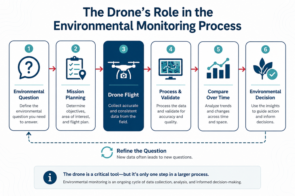
Environmental monitoring is a step-by-step process, in which each decision influences the next:
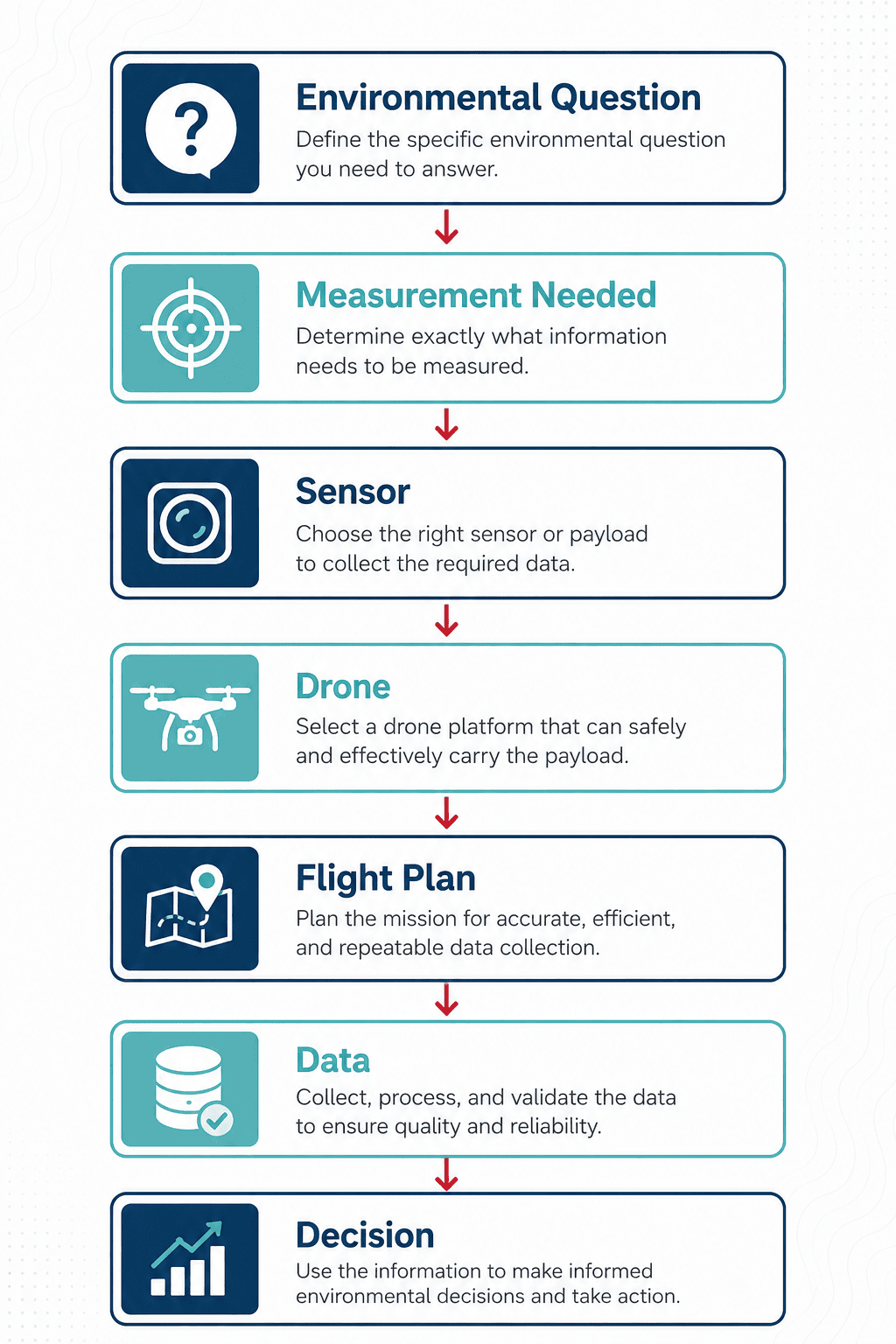
Depending on the mission, a drone might photograph a wetland, map changes in a coastline, identify heat differences in a body of water, measure gases in the air, or collect a physical water sample.
The drone provides access and mobility. And the camera, sensor, or sampling device determines what can actually be measured.
This distinction matters because environmental monitoring usually begins with a question—not a drone.
For example, a team studying riverbank erosion may need repeatable maps that show changes in elevation, or a wildlife biologist may need high-resolution images for counting animals.
Those projects might use similar drones but their payloads, flight plans, processing methods, and final deliverables will be different.
Observation, Mapping, Remote Sensing, and Sampling
Most environmental drone missions fall into four broad categories:
1. Observation uses a drone to view and document conditions from the air.
This might include photographing a visible spill, inspecting storm damage, locating wildlife, or viewing an area that would be unsafe to approach on foot.
The result is aerial imagery or video that helps a person understand what is happening at a site.
2. Mapping uses overlapping images to make a measurable record of an area.
Common outputs include orthomosaic maps, elevation models, point clouds, and 3D models.
Mapping is useful when the location and size of a feature matter. Instead of just seeing that a shoreline has eroded, for example, a team can compare drone maps and measure where—and by how much—the shoreline has moved.
3. Remote sensing means using a drone to collect data with a specialized sensor.
Here are some specialized drone sensors commonly used for environmental monitoring:
- A multispectral camera can capture differences in the light reflected by vegetation.
- A thermal camera records surface-temperature patterns.
- LiDAR measures distance with laser pulses, allowing operators to map terrain, vegetation structure, and other physical features.
- Gas sensors can measure concentrations of specific gases or airborne particles.
4. Sampling involves physically collecting material for later analysis.
A drone might lower a container into a pond, collect an air sample inside a plume, or carry another device designed to retrieve material from a difficult location.
Sampling can provide information that imagery alone can’t. A photograph might show discolored water, for example, but a laboratory sample may be needed to determine which substances are present.
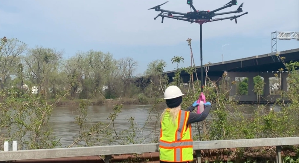
A drone equipped with a water-collection device called a Nixie System | Credit: Reign Maker
8 Ways Drones Are Used for Environmental Monitoring
Drones are used for environmental monitoring whenever an aerial view, specialized sensor, or repeatable flight can help researchers and organizations better understand conditions on the ground.
Some missions rely on standard imagery, while others use multispectral, thermal, LiDAR, gas-detection, or water-sampling payloads to collect data that can’t be captured with a conventional camera.
Below are the eight most common ways drones are used in environmental monitoring.
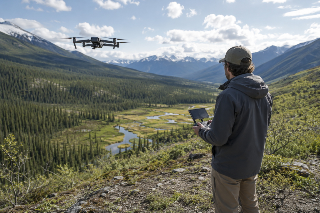
1. Habitat and Conservation Monitoring
Drones help conservation teams map habitats, document environmental change, and evaluate restoration projects over time.
Repeating the same survey lets researchers compare conditions and measure how ecosystems are changing.
Common applications include:
- Mapping habitat boundaries
- Measuring vegetation coverage
- Locating invasive plant species
- Documenting fire, flood, or storm damage
- Tracking restoration progress
- Identifying areas for closer field inspection
2. Wildlife Surveys
Researchers use drones to locate, count, and observe wildlife while reducing the need to access difficult or sensitive terrain.
RGB (i.e., visual) and thermal imagery can both support wildlife monitoring, though flights should be planned to minimize disturbance.
Common applications include:
- Estimating wildlife populations
- Locating nests and breeding sites
- Monitoring animal behavior
- Documenting visible signs of injury or physical condition
- Detecting animals with thermal cameras
- Surveying inaccessible habitat
3. Vegetation and Plant Health Monitoring
RGB and multispectral sensors help researchers identify changes in vegetation, compare restoration projects, and monitor ecosystem health.
Vegetation indices reveal patterns that often require field observations for confirmation.
Common applications include:
- Monitoring forest and wetland health
- Mapping invasive species
- Assessing restoration projects
- Locating plant stress
- Measuring canopy coverage
- Comparing conditions over time
4. Erosion, Shoreline, and Landscape Change
Drones create repeatable maps and 3D models that allow researchers to measure changes in terrain over time.
Comparing surveys helps quantify where land has been lost, deposited, or displaced.
Common applications include:
- Shoreline and riverbank erosion
- Coastal dune movement
- Landslide monitoring
- Sediment movement
- Mine reclamation
- Post-disaster landscape assessment
5. Water and Watershed Monitoring
Environmental teams use drones to map waterways, identify visible changes, measure surface temperatures, and collect water samples. Depending on the project, imagery and sampling may be used together.
Common applications include:
- Flood and drainage mapping
- Sediment plume monitoring
- Wetland mapping
- Stream and shoreline monitoring
- Oil or chemical spill documentation
- Water sample collection
6. Air Quality and Emissions Monitoring
Specialized payloads allow drones to collect air-quality measurements in locations that may be difficult or hazardous to reach. Reliable results depend on careful flight planning, sensor placement, and calibration.
Common applications include:
- Wildfire smoke sampling
- Industrial emissions monitoring
- Methane leak detection
- Pollution plume mapping
- Atmospheric sampling
7. Pollution Response and Environmental Compliance
Drones can help organizations document contamination, monitor cleanup efforts, and improve site awareness after environmental incidents. They often support field investigations without replacing required regulatory testing methods.
Common applications include:
- Documenting spills and releases
- Mapping contaminated areas
- Inspecting containment systems
- Monitoring remediation projects
- Collecting air or water samples
- Creating time-stamped site records
8. Wildfire and Natural-Hazard Assessment
Drones provide rapid situational awareness before, during, and after natural disasters. They help responders and researchers document changing conditions while reducing exposure to hazardous environments.
Common applications include:
- Burned-area mapping
- Wildfire hot-spot detection
- Post-fire vegetation assessment
- Flood damage documentation
- Landslide assessment
- Volcanic or storm damage mapping
What Can Environmental Drones Measure?
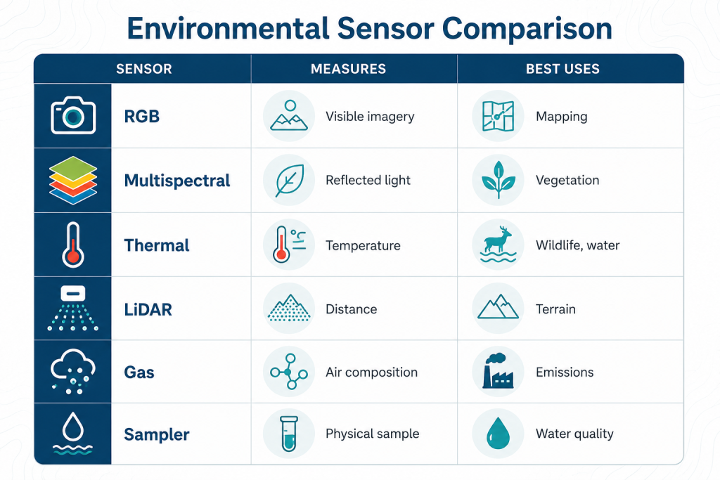
Environmental drones can collect many types of data, depending on the payload you’re using.
In many monitoring programs, multiple sensors are used together to build a more complete picture of environmental conditions.
Here’s a quick overview:
RGB Cameras
RGB cameras capture visible light, producing the photographs and videos most people associate with drones.
They are the foundation of many environmental monitoring projects because they can document conditions and generate detailed maps through photogrammetry.
Common applications for drone RGB cameras include:
- Documenting habitat conditions
- Mapping shorelines and wetlands
- Measuring erosion and landscape change
- Identifying storm or wildfire damage
- Locating visible pollution or debris
- Creating baseline site documentation
Thermal Cameras
Thermal cameras measure infrared radiation, allowing operators to identify temperature differences across a landscape. These differences can reveal patterns that are invisible in standard RGB imagery.
Thermal imagery highlights temperature differences, but sunlight, weather, vegetation, and surface materials can all influence the results.
Common applications for drone thermal cameras include:
- Locating wildlife
- Finding groundwater inflows
- Studying surface-water temperature patterns
- Monitoring wildfires and hot spots
- Identifying thermal anomalies around industrial sites
LiDAR Sensors
LiDAR (Light Detection and Ranging) uses laser pulses to create highly accurate three-dimensional maps of terrain and vegetation. It’s especially valuable when elevation data is more important than traditional imagery.
Compared to camera-based mapping, LiDAR often produces more accurate elevation data but typically requires specialized hardware, software, and expertise.
Common applications for LiDAR drones include:
- Floodplain mapping
- Forest structure analysis
- Coastal and riverbank monitoring
- Landslide assessment
- Terrain modeling beneath sparse vegetation
Multispectral Cameras
Multispectral cameras measure reflected light beyond the visible spectrum, helping researchers identify patterns that may not appear in standard imagery. They’re widely used to evaluate vegetation and compare environmental conditions over time.
These sensors measure reflected light rather than plant health directly, so the results should be interpreted alongside field observations and local conditions.
Common applications for drone multispectral cameras include:
- Monitoring vegetation health
- Mapping invasive plant species
- Evaluating habitat restoration
- Tracking forest change
- Comparing seasonal vegetation growth
Gas Detection and Air Quality Sensors
Gas sensors measure specific atmospheric gases or airborne particles that cannot be detected with conventional cameras. Collecting reliable measurements requires careful mission planning and sensor calibration.
Sensor placement, airflow, weather, and flight design all influence data quality, making validated monitoring procedures just as important as the sensor itself.
Common applications for gas detection drones include:
- Industrial emissions monitoring
- Methane leak detection
- Wildfire smoke research
- Air-quality investigations
- Environmental compliance studies
Water Sampling Systems
Some environmental drones collect physical water samples instead of remote sensing data. These systems allow operators to safely retrieve samples from locations that may be difficult or hazardous to reach.
Rather than making the measurement directly, the drone’s role is to collect a representative sample for laboratory analysis.
Common applications for weathering sampling drones include:
- Collecting nutrient samples
- Testing for bacteria
- Measuring heavy metals
- Analyzing chemical contaminants
- Supporting laboratory water-quality testing
Choosing the Right Sensor
Many environmental monitoring programs use more than one sensor over the course of a project.
For example, a team might make an RGB map of a site, use a multispectral camera to identify areas of vegetation stress, and then collect water or soil samples to investigate those areas more closely.
That means that, rather than asking, “Which drone is best for environmental monitoring?” a better question is: “What environmental condition am I trying to measure?”
| If you want to… | Consider using… |
|---|---|
| Document sites or create detailed maps | RGB camera |
| Measure terrain and elevation | LiDAR |
| Monitor vegetation health | Multispectral camera |
| Locate heat patterns or hot spots | Thermal camera |
| Measure gases or emissions | Gas detection sensor |
| Collect water-quality samples | Water sampling system |
Once you know what needs to be measured, choosing the right sensor—and a drone that can carry it—becomes a lot more straightforward.
How a Drone Environmental Monitoring Mission Works
Environmental monitoring begins long before a drone takes off. The drone is just one part of a larger workflow that includes planning, data collection, processing, analysis, and decision-making.
While every project is different, most monitoring missions follow the same general process:
Step 1: Define the Environmental Question
Every monitoring program begins with a clear question. That question determines what data needs to be collected and shapes every decision that follows.
For example:
- Is this shoreline eroding?
- Where is methane escaping from this facility?
- Has this wetland expanded or contracted?
- How many nesting birds are using this habitat?
A project measuring erosion requires a very different workflow than one surveying wildlife or monitoring air quality.
Step 2: Choose the Right Sensor and Drone
The monitoring objective determines the payload first and the aircraft second. In many cases, multiple drones can perform the mission, but only certain sensors can collect the required data.
Depending on the project, teams may use:
- RGB cameras
- Multispectral cameras
- Thermal cameras
- LiDAR sensors
- Gas detection sensors
- Water sampling systems
Step 3: Plan a Repeatable Flight
Environmental monitoring depends on consistency. If surveys will be compared over time, each mission should be flown using a similar methodology whenever practical.
That often means keeping these factors as consistent as possible:
- Flight altitude
- Image overlap
- Flight speed
- Camera angle
- Ground sampling distance (GSD)
- Time of day
- Season
Consistent collection methods make it easier to determine whether changes came from the environment rather than the survey itself.
Step 4: Collect and Process the Data
After the flight, team members process imagery and sensor measurements into datasets that can be analyzed. The exact workflow depends on the sensor and the monitoring objective.
Quality control at this stage helps ensure the results are accurate and complete before analysis begins.
Processing may include:
- Creating orthomosaic maps
- Building elevation models
- Generating LiDAR point clouds
- Calculating vegetation indices
- Producing thermal maps
- Reviewing imagery for wildlife counts
- Validating sensor measurements
Step 5: Compare Results Over Time
Monitoring is fundamentally about identifying change. Once a baseline has been established, future surveys can be compared using the same methods and standards.
Long-term trends are generally more meaningful than the results of a single survey.
Teams may compare:
- Vegetation coverage
- Wildlife populations
- Shoreline movement
- Habitat fragmentation
- Surface temperatures
Step 6: Turn Data into Decisions
The goal of environmental monitoring is to support better decisions, not just collect more data.
Drone imagery and sensor measurements are often combined with field observations and other information before action is taken.
The results may be used to do things like:
- Prioritize habitat restoration
- Investigate pollution sources
- Document regulatory compliance
- Allocate resources after natural disasters
How to Build a Drone Environmental Monitoring Program
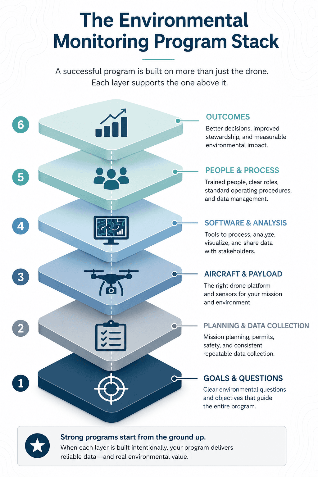
A successful drone environmental monitoring program is built on more than the drone itself.
It combines clear objectives, repeatable data collection, the right hardware and software, trained people, and a process for turning results into action.
The six layers below work together to create environmental data that can be trusted and used to support real-life decisions.
1. Goals & Questions
Start by defining the environmental condition you need to understand and the decision the data will support. A clear objective determines what must be measured and helps prevent the technology from driving the project.
The question should be specific enough to guide the sensor, flight plan, processing method, and final deliverable.
The clearer the objective, the easier it becomes to design the rest of the program.
2. Planning & Data Collection
The mission plan should define how, where, and when the data will be collected. For long-term monitoring, the process must also be repeatable enough to produce meaningful comparisons.
Planning should address:
- Flight area and altitude
- Image overlap or sampling pattern
- Time of day and season
- Positioning and ground control
- Safety, permits, and airspace requirements
3. Drone & Payload
Once the required measurement is clear, select a payload that can collect it and an aircraft that can support the mission reliably.
Beyond payload compatibility, consider flight endurance, positioning accuracy, automated mission planning, operating conditions, maintenance, and whether the system fits the team’s existing software and field workflow.
For many projects, the right sensor and a consistent workflow matter more than choosing the drone with the most impressive specifications.
The system should provide:
- Compatibility with the required payload
- Enough flight time for the survey area
- Appropriate positioning accuracy
- Stable and repeatable automated flight
- Reliable performance in the operating environment
4. Software & Analysis
Raw imagery and sensor readings usually require processing before they can answer an environmental question. The software workflow should support the required outputs and make it practical to compare results over time.
Depending on the project, that workflow may include:
- Mission-planning software
- Photogrammetry or LiDAR processing
- Thermal or multispectral analysis
- GIS mapping and comparison tools
- Data storage, visualization, and sharing
Compatibility between these tools can have a major impact on how quickly collected data becomes useful information.
5. People & Process
Reliable monitoring depends on trained people following a documented process. Clear roles and standard operating procedures help teams collect, process, and manage data consistently across multiple missions.
A capable drone can’t compensate for inconsistent methods or unclear responsibility for the final dataset.
A mature program should define:
- Pilot and analyst responsibilities
- Flight and data-collection procedures
- Sensor calibration requirements
- Quality-control standards
- Data storage and record-keeping practices
6. Outcomes
The purpose of the program is not simply to collect more data. It’s to produce reliable evidence that helps an organization understand changing conditions and decide what to do next.
The strongest programs connect every flight to a defined environmental question, a measurable outcome, and a clear decision-making process.
Monitoring results may support:
- Habitat restoration priorities
- Pollution investigations
- Land-management decisions
- Additional field sampling
- Environmental reporting or compliance work
Special Considerations for Drone Environmental Monitoring
Environmental monitoring often requires a different approach than other types of drone operations because protecting the environment is just as important as documenting it.
In addition to flying safely, operators should consider how wildlife, environmental conditions, data management, and long-term consistency can affect both the environment and the quality of the results.
Here are some best practices to keep in mind.
1. Minimize Disturbance to Wildlife
One of the biggest advantages of drones is their ability to observe wildlife from a distance. But they can also change animal behavior if you fly too closely or at sensitive times.
When planning wildlife missions, consider:
- The species being observed
- Nesting or breeding seasons
- Flight altitude
- Aircraft noise and approach direction
- Established monitoring protocols
The goal is to collect useful data while minimizing unnecessary impacts on the animals and habitats being studied.
2. Collect Data Under Similar Conditions
Environmental conditions can influence both the quality of the data and the conclusions drawn from it. When monitoring change over time, collecting data under similar conditions helps make comparisons more meaningful.
Keep in mind:
- Time of day
- Season
- Weather conditions
- Water levels or tides
- Flight altitude and camera settings
Reducing unnecessary variation makes it easier to determine whether observed differences reflect environmental change or just different collection conditions.
3. Think Beyond the Flight
The flight is only one part of a successful monitoring mission. Before leaving the field, verify that the collected data is complete, properly documented, and ready for analysis.
A good field workflow includes:
- Reviewing imagery and sensor data for completeness
- Backing up files before leaving the site
- Recording flight conditions and metadata
- Documenting any unusual observations
- Verifying that the planned coverage was completed
A few minutes of quality control in the field can prevent costly repeat visits later.
4. Plan for Long-Term Monitoring
Most environmental monitoring projects return to the same location over months or years. Building consistency into the program from the beginning makes it easier to compare surveys and identify meaningful trends.
Long-term programs should aim to maintain:
- The same flight procedures
- Consistent sensor settings
- Repeatable processing workflows
- Standardized quality-control practices
- Well-organized historical records
Environmental monitoring is most valuable when each survey builds on the last, creating a reliable record of how conditions are changing over time.
5. Protect Sensitive Environmental Data
Environmental datasets can contain information about endangered species, sensitive habitats, cultural resources, or critical infrastructure.
Consider how imagery, maps, and location data will be stored, shared, and published.
Depending on the project, this may include:
- Protecting the locations of sensitive species
- Following agency or landowner data-sharing requirements
- Limiting access to confidential datasets
- Maintaining accurate metadata and documentation
- Using secure storage and backup practices
Managing environmental data responsibly is an important part of building trust with landowners, researchers, agencies, and the public.
Drone Environmental Monitoring FAQ
Here are answers to some of the most commonly asked questions about drones in environmental monitoring.
What is drone environmental monitoring?
Drone environmental monitoring is the use of drones to observe, measure, or collect information about environmental conditions. Depending on the project, drones may carry RGB cameras, multispectral cameras, thermal sensors, LiDAR systems, gas detectors, or water-sampling equipment to support conservation, research, regulatory, and industrial monitoring.
What are drones used to monitor?
Environmental drones are used to monitor habitats, wildlife, vegetation, coastlines, rivers, wetlands, forests, industrial emissions, pollution events, flood damage, wildfire impacts, and many other environmental conditions. The exact application depends on the sensor the drone carries and the environmental question the team is investigating.
Can drones measure air quality?
Some drones can carry specialized air-quality or gas-detection sensors that measure pollutants such as methane or other atmospheric gases. The quality of the data depends on factors like the specific sensor, calibration, flight design, weather conditions, and the monitoring methodology.
Can drones test water quality?
Some drones can carry sensors that measure specific water conditions or use specialized equipment to collect physical samples.
Parameters like bacteria, nutrients, heavy metals, and many chemical contaminants typically require laboratory analysis, while other measurements may be collected in the field. The right method depends on what the monitoring team needs to measure.
Are drones better than satellites for environmental monitoring?
Neither is universally better. Satellites can monitor very large areas and revisit them regularly, while drones provide much higher spatial resolution and can collect detailed data for specific sites. Many environmental monitoring programs use both together.
What is the best drone for environmental monitoring?
There isn’t a single best environmental monitoring drone. The right platform depends on the sensor required, the size of the survey area, flight endurance, positioning accuracy, software workflow, and the environmental data being collected.
Do I need a Part 107 license for environmental monitoring?
Yes. In the U.S., environmental monitoring conducted for work or another non-recreational purpose falls under the FAA’s Part 107 rules. That means the person acting as remote pilot in command must hold an FAA Remote Pilot Certificate. (Recreational rules only apply when the flight is conducted strictly for recreational purposes.)
When should you use a drone for environmental monitoring?
Drones are a strong option when a project requires detailed, repeatable data from a defined site, especially when the terrain is difficult to access or conditions need to be documented from above. They may be less suitable when continuous monitoring is required, the survey area is extremely large, or the condition being studied must be measured through ground sampling or another method.