

Drones for Bridge Inspections: An In-Depth Guide [New for 2026]
BY Zacc Dukowitz
5 February 2026Bridge drones is a term that refers to any drone used in bridge inspections.
Some drones are made specifically for the unique challenges you’ll find inspecting bridges. And some drones are made for more general purposes, but can still work just fine as a bridge drone.

Credit: Skydio
Bridge inspections have always been challenging. And that’s because:
- They’re expensive. Traditional bridge inspections require extensive equipment, road closures, and labor.
- They’re dangerous. Inspectors doing bridge inspections often work at dangerous heights or over water, increasing the risk of accidents.
- It’s hard to get access. Certain areas, like the underside of long-span bridges, are hard or impossible to reach without specialized equipment.
Drones solve all three problems.
They make inspections a lot less expensive since they eliminate the need for equipment like snooper trucks. And they eliminate the need for inspectors to work at height to collect data. Plus, they can get into the areas you need under the bridge, solving accessibility issues.
In this guide to bridge drones we’ll cover the top platforms on the market, how a drone bridge inspection works, and answer commonly asked questions about drones and bridge inspections.
Here’s a menu in case you’d like to jump around:
- Best Drones for Bridge Inspections 2026
- How Drones Are Used in Bridge Inspections
- 6 Benefits of Using a Drone for Bridge Inspections
- The Future of Bridge Drone Technology
- Bridge Drone FAQ
Best Drones for Bridge Inspections in 2026
Looking for a bridge drone?
Here are the top models, divided into three groups: High end, mid-range, and budget-friendly, with two options for each.
1. High End: Elios 3

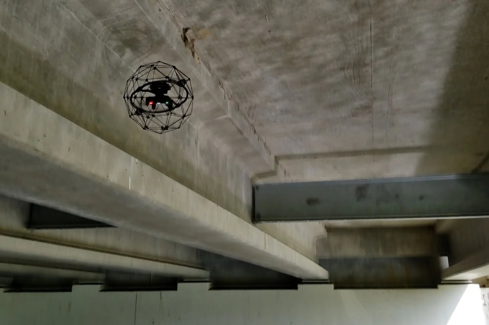
The Elios 3, developed by Flyability, is a rugged indoor drone designed for confined-space operations where traditional drones can’t safely fly.
Its collision-tolerant design and LiDAR-based 3D mapping make it a top high-end option for industrial inspections.
Good for bridge inspections because:
- Collision-tolerant design. Its carbon fiber protective cage allows it to safely navigate under bridges, inside box girders, and in other confined areas.
- GPS-free navigation. Operates effectively in GPS-denied environments, such as beneath large steel structures.
- Real-time 3D mapping. LiDAR-based SLAM technology provides high-accuracy digital models of bridge structures.
- Crack and corrosion detection. High-resolution 4K camera and thermal imaging help identify structural damage.
Specs
- Camera. 4K RGB camera with thermal imaging for detailed inspections in low-light conditions.
- Battery life. Up to 12 minutes.
- Weight. Approximately 3.7 pounds (1.7 kg).
- Mapping. LiDAR-based SLAM technology for real-time 3D modeling and navigation.
2. High End: Voliro T

The Voliro T is an advanced aerial robotic platform designed for non-destructive testing (NDT) and inspection tasks, particularly in challenging environments.
Its unique tiltable rotor design allows for stable contact-based interactions with structures, enabling precise inspections at various orientations.
Good for bridge inspections because:
- Omnidirectional mobility: The drone’s 6-degree-of-freedom control enables it to approach and interact with bridge components from any angle, facilitating comprehensive inspections.
- Contact-based NDT capabilities. Equipped with sensors like ultrasonic transducers (UT) and electromagnetic acoustic transducers (EMAT), the Voliro T can perform thickness measurements and detect subsurface defects in bridge materials.
- Stable force application. Capable of applying up to 30 N of force, it ensures consistent contact for accurate data collection during inspections.
- Operation in GPS-denied environments. Advanced sensors and AI-assisted navigation allow the Voliro T to function effectively under bridges and in areas with limited GPS.
Specs
- Weight. 8 pounds (3.7 kg).
- Camera. 4K 12 MP with an 80° horizontal field of view.
- Lighting. Up to 17k lumens, adjustable via remote control.
- Sensing system. Includes a depth camera, six LiDAR distance sensors, six vision-based velocity sensors, and RTK GPS.
3. Mid-Range: Skydio X10

The Skydio X10 is a professional-grade autonomous drone designed for complex inspection tasks, including bridge assessments. Its advanced AI capabilities and robust sensor suite make it a solid option for infrastructure inspections.
Good for bridge inspections because:
- Advanced autonomy. Equipped with six 360-degree navigation cameras and an onboard spatial AI engine, the X10 provides complete environmental awareness and robust obstacle detection, even in GPS-denied environments, facilitating safe and efficient bridge inspections. :contentReference[oaicite:0]{index=0}
- High-resolution imaging. The drone’s modular payload system includes options like a 64MP narrow camera, a 50MP wide-angle camera, and a 48MP telephoto lens, enabling detailed visual assessments of bridge structures.
- Thermal imaging. Integrated Teledyne FLIR Boson+ radiometric thermal camera allows inspectors to detect temperature anomalies, aiding in the identification of structural issues not visible to the naked eye.
- Onboard 3D modeling. Features like Onboard Modeling enable real-time 3D reconstruction without the need for an internet connection, providing immediate insights during bridge inspections.
Specs
- Weight. 4.65 lbs (2.11 kg ).
- Flight time. Up to 40 minutes
- Weather resistance. IP55 rating, certified against dust and water
- Deployment time. Ready to fly in under 40 seconds
4. Mid-Range: DJI Matrice 350 RTK
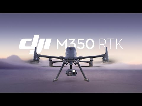
The DJI Matrice 350 RTK was designed to meet the rigorous demands of industrial applications, including bridge inspections. With enhanced flight performance, robust safety features, and versatile payload support, it sets a new standard for aerial operations.
Good for bridge inspections because:
- Extended flight time. Capable of flying for up to 55 minutes, allowing comprehensive coverage of large bridge structures without frequent battery changes.
- High payload capacity. Supports multiple payload configurations, including single and dual downward gimbals and an upward gimbal, accommodating various sensors and cameras essential for detailed inspections.
- Advanced obstacle sensing. Equipped with six-directional sensing and positioning systems, enhancing safety and precision during complex inspection tasks.
- All-weather operation. With an IP55 rating, the drone can operate reliably in diverse environmental conditions, ensuring consistent inspection schedules.
- Night-vision. The integrated night-vision FPV camera enables effective inspections in low-light or nighttime conditions..
Specs
- Weight. Approximately 8 pounds (3.77 kg)
- Maximum Payload Capacity: 6 pounds (2.7 kg)
- Flight time. 55 minutes
- Weather resistance. IP55 rating
5. Budget Friendly: DJI Mavic 3 Enterprise

The DJI Mavic 3 Enterprise (M3E) is a compact and versatile drone tailored for industrial applications, including bridge inspections. Its advanced imaging capabilities and user-friendly design make it a valuable tool for infrastructure assessments.
Good for bridge inspections because:
- Mechanical shutter. The M3E’s mechanical shutter eliminates motion blur, ensuring crisp images during inspections.
- High-resolution imaging. Equipped with a 20 MP wide camera and a 56× hybrid zoom, it captures detailed visuals of bridge components.
- Compact and portable. Its lightweight design allows for easy deployment and operation in various environments.
Specs
- Weight. Approximately 2 pounds (915 g)
- Flight time. Up to 45 minutes
- Camera. 20 MP wide camera with mechanical shutter; 56× hybrid zoom
- RTK module. Supports centimeter-level positioning accuracy
6. Budget Friendly: Parrot ANAFI USA

The Parrot ANAFI is a compact and lightweight drone designed for both recreational and professional use. Its portability and advanced imaging capabilities make it a reliable option for bridge inspections, especially for teams seeking an affordable yet effective solution.
Good for bridge inspections because:
- 180° tilt gimbal. Allows inspection of both the underside and topside of bridge structures without complex maneuvers. :contentReference[oaicite:0]{index=0}
- 3× zoom lens. Enables detailed examination of hard-to-reach areas without compromising image quality. :contentReference[oaicite:1]{index=1}
- Compact and lightweight. Weighing only 320 grams, it’s easy to deploy in various environments, including confined spaces. :contentReference[oaicite:2]{index=2}
Main Specifications
- Weight. 1.1 pounds (500 grams)
- Flight time. Up to 25 minutes
- Camera. 21 MP sensor capable of 4K HDR video recording with up to 3x digital zoom
How Drones Are Used in Bridge Inspections
Bridge drone inspections have revolutionized the way infrastructure assessments are conducted, making them safer, faster, and less expensive.
But how exactly do they work? Let’s take a look.
Credit: Flyability
1. Drones for Visual Inspections
One of the primary uses of a drone bridge inspection is visual assessment. Equipped with high-resolution cameras, drones can capture detailed images of bridge surfaces, allowing engineers to detect:
- Cracks. Small fractures in concrete or steel structures can indicate underlying stress or material degradation.
- Corrosion. Rust formation on steel components is a major concern for bridge integrity, and drones provide close-up images for analysis.
- Structural misalignments. Drones help engineers detect shifts or misalignments in bridge components that may indicate structural instability.
2. Thermal Imaging for Detecting Structural Weaknesses
Drones equipped with thermal cameras can reveal hidden defects in a bridge, which aren’t visible to the naked eye.
In bridge inspections, thermal imaging helps with:
- Moisture detection. Water infiltration can weaken bridge materials over time. Thermal cameras identify temperature variations that indicate trapped moisture.
- Delamination identification. In concrete structures, air pockets or separating layers (delamination) can be detected through heat signatures.
- Cold joints and poor bonding. Variations in thermal conductivity reveal construction flaws or aging-related weaknesses.
3. LiDAR for 3D Mapping and Precision Measurements
LiDAR (Light Detection and Ranging) technology is one of the most powerful tools in modern bridge drone inspection. By emitting laser pulses and measuring their reflections, LiDAR drones can help engineers:
- Make 3D structural maps. Inspectors can make high-precision digital models of bridges to assess deformation, alignment, and load distribution.
- Make clearance measurements. Ensuring proper clearance heights for vehicles, ships, and trains passing under bridges.
- Do comparative analysis millimeter-level accuracy. Engineers can track structural shifts over time with millimeter-level accuracy in detailed comparative analyses.
4. AI-Powered Anomaly Detection and Predictive Maintenance
With advancements in artificial intelligence, drones can now process captured data in real time, helping inspectors:
- Automate crack detection. AI algorithms can identify even the smallest cracks in bridge surfaces and classify them based on severity.
- Automate reporting. AI-driven software can generate inspection reports with risk assessments, reducing manual labor for engineers.
- Forecast predictive maintenance. By analyzing past inspection data, AI can forecast when and where structural weaknesses are likely to develop.
5. Advanced Sensor Technologies in Drone Bridge Inspections
In addition to visual, thermal, and LiDAR data, high-end inspection drones equipped with advanced sensors are allowing inspectors to collect more types of data by drone than ever before.
These sensors enable more comprehensive assessments of structural integrity by detecting issues that traditional methods might overlook.
Here are some of the main types of advanced sensors inspectors are using in bridge inspections today:
- Ultrasonic Testing (UT). Uses high-frequency sound waves to measure material thickness and detect internal defects.
- Pulsed Eddy Current (PEC). Identifies corrosion beneath coatings or insulation without requiring removal, helping assess material loss.
- Dry Film Thickness (DFT) Measurement. Evaluates the thickness of protective coatings on bridge components to ensure compliance with maintenance standards.

6 Benefits of Using Drones for Bridge Inspections
Advancements in drone technology have made them an essential tool for infrastructure maintenance.
Compared to traditional inspection methods, drones provide significant improvements in safety, cost, efficiency, data accuracy, and environmental impact.

Credit: Skydio
Here the top 6 benefits of using drones to inspect bridges:
1. Improved Safety
Traditional bridge inspections require inspectors to work at dangerous heights, often using scaffolding, bucket trucks, or rope access to reach critical areas.
Drones eliminate these risks by allowing inspectors to collect detailed data remotely, keeping them safe by:
- Minimizing fall risks. Inspectors no longer need to climb bridge structures or work near high-traffic areas.
- Making overwater inspections safer. Drones eliminate the need for boats or underwater diving operations in bridge assessments.
- Reducing traffic disruptions. Traditional methods often require lane closures, which pose additional risks for both workers and drivers.
2. Significant Cost Savings
Drones make bridge inspections a lot less expensive, providing savings by:
The use of drones for bridge inspection eliminates many of the costs associated with traditional inspection methods.
- Eliminating the need for scaffolding and aerial lifts. Drones replace costly scaffolding, cranes, and bucket trucks.
- Lowering labor costs. Fewer personnel are needed for drone-based inspections compared to manual assessments.
- Reducing traffic control expenses. Traditional inspections often require road closures and detours, adding logistical costs.
3. Increased Efficiency
A bridge drone inspection can be completed in a fraction of the time required for traditional methods, making the entire process more efficient by:
- Speeding data collection. Drones can inspect large areas in minutes, compared to hours or days for manual inspections.
- Enabling real-time reporting. Data is immediately available for analysis, allowing for quicker decision-making.
- Minimizing disruptions. Inspections can be conducted without affecting daily traffic flow.
4. Higher Data Accuracy and Detail
Equipped with high-resolution cameras, LiDAR, and thermal imaging, drones provide a level of precision that is hard to achieve in manual inspections, giving inspectors:
- High-resolution imaging. Drones capture detailed photos and videos, allowing engineers to detect cracks, corrosion, and structural anomalies.
- LiDAR scans. Creates accurate 3D models for in-depth structural analysis.
- Thermal imaging. Identifies hidden defects such as moisture intrusion and material degradation.
5. Environmental Benefits
Using drones for bridge inspection contributes to sustainability by reducing the carbon footprint associated with traditional inspections, leading to:
- Fewer vehicle emissions. Eliminates the need for fuel-intensive aerial lifts and large inspection vehicles.
- Minimal impact on surroundings. Reduces physical disruption to natural habitats near bridges.
- Less resource waste. Digital data collection reduces reliance on paper-based documentation.
6. Integration with GIS and CAD Engineering Software
Another benefit of using drones for bridge inspections is the ability to seamlessly integrate collected data into engineering platforms such as:
- GIS (Geographic Information Systems). Allows for geospatial analysis of bridges, helping identify environmental factors affecting their stability.
- CAD (Computer-Aided Design). Engineers can overlay drone data onto existing bridge models to detect deviations and structural wear.
- Digital twin technology. High-fidelity 3D models enable real-time simulation of bridge conditions for ongoing monitoring.
The Future of Bridge Drone Technology
For infrastructure professionals, adopting drone technology is no longer just an option—it is a necessity.
Maintenance teams who integrate the drones into their bridge inspection workflow will benefit from increased operational efficiency, better decision-making, and improved infrastructure resilience.
And as drone technology continues to evolve, drones will only become more and more useful for inspecting bridges.

Credit: Skydio
Here are four areas to look out for on the horizon of bridge drones:
1. AI-Powered Defect Detection and Predictive Maintenance
One of the most significant advancements in bridge drone inspection technology is the integration of AI for defect detection and predictive maintenance.
AI algorithms can analyze high-resolution images and LiDAR scans to detect structural weaknesses, cracks, or corrosion with unparalleled precision. These AI-driven systems can also forecast deterioration patterns, allowing engineers to perform proactive maintenance and prevent costly structural failures.
2. Autonomous Drone Ops and BVLOS Advancements
Autonomous operations are revolutionizing the inspection process. And, with improvements in Beyond Visual Line of Sight (BVLOS) capabilities, drones can now inspect bridges without requiring a pilot to be physically present.
Automated flight paths and obstacle avoidance technology enable drones to navigate complex bridge structures safely and efficiently, further reducing labor costs and improving inspection accuracy.
3. Next-Gen LiDAR and Imaging Technology
Future bridge inspection drones will feature even further enhanced LiDAR and imaging capabilities, providing even more detailed 3D models of bridge structures. LiDAR systems on newer drones will offer higher-resolution point clouds, enabling engineers to detect even the smallest deformations.
Additionally, advancements in thermal imaging and multispectral cameras will allow drones to identify material fatigue, water infiltration, and hidden structural issues that would otherwise go unnoticed.
4. Regulatory Changes and Industry Adoption
The FAA’s upcoming Part 108 rule is expected to standardize BVLOS operations for commercial drones, potentially enabling more efficient bridge inspections. By allowing drones to operate beyond visual line of sight, inspectors could access hard-to-reach areas of bridges more easily and safely, enhancing the scope and effectiveness of inspections15.
FAQ: Bridge Drones and Bridge Inspections
Here are answers to some of the most commonly asked questions about drones and bridge inspections.
Can I fly a drone under a bridge?
Yes, you can fly a drone under a bridge, but it’s important to follow FAA regulations and local laws. In the U.S., commercial drone pilots must operate under Part 107 rules, which include maintaining visual line of sight (VLOS) and avoiding operations in restricted airspace. Some bridges may require specific waivers or permissions, especially if they are in controlled airspace or high-traffic areas.
How are drones used in bridge inspections?
Bridge drone inspections involve using unmanned aerial vehicles (UAVs) equipped with high-resolution cameras, LiDAR, and thermal imaging sensors to assess the condition of bridges. Drones help identify structural issues such as cracks, corrosion, and material fatigue without requiring inspectors to use scaffolding or aerial lifts. They also create detailed 3D models for long-term monitoring and maintenance planning.
What are the best drones for bridge inspections?
The best drones for bridge inspection include models equipped with advanced imaging and navigation technology. Jump to our list of top choices.
Do you need a license to use drones for bridge inspections?
Yes, commercial drone pilots conducting bridge drone inspections must obtain a drone license, formally known as a Part 107 Remote Pilot Certificate. Additional permissions, such as waivers for Beyond Visual Line of Sight (BVLOS) operations, may be required depending on the location and complexity of the inspection.
What types of data do drones collect during bridge inspections?
Bridge drones capture a variety of data, including:
- High-resolution images for visual assessments.
- Thermal imaging to detect heat variations and potential structural weaknesses.
- LiDAR scans for 3D mapping and precise measurements.
Are drones replacing human bridge inspectors?
No, drones are not replacing human inspectors but are instead enhancing their capabilities and making their work safer. Drones provide detailed imaging and real-time data, allowing inspectors to focus on analyzing findings and making informed decisions about maintenance and repairs.
What regulations apply to using drones for bridge inspections?
In the U.S., the FAA regulates drones for bridge inspection under Part 107 rules. Operators must maintain VLOS, avoid flying over people, and obtain waivers for BVLOS operations. Some states and local authorities may have additional restrictions, so it is important to check regulations before conducting an inspection.
How do bridge inspection drones handle GPS-denied environments?
Some bridges, especially those made of metal or located in urban areas, can interfere with GPS signals. Advanced bridge inspection drones like the Elios 3 and Voliro T use vision-based navigation, LiDAR, and AI-powered obstacle avoidance to operate effectively in GPS-denied environments.


