

Drones for Good: 11 Ways Drones Helped Make the World a Better Place in 2020
BY Zacc Dukowitz
31 December 2020Although 2020 has been a very tough year, it’s also been a year in which drone technology has helped people all over the world.
This year, drones have proved their value as a tool in our efforts to fight the ongoing COVID-19 pandemic, and they’ve also been used in many other ways to do good—some of them new, and some of them scaled-up versions of previous applications.
Keep reading for our list of the top 11 drones for good stories from 2020 to see all the ways that drone technology helped make the world a better place this year.
[Related reading—Drones for Good: 25 Inspiring Examples of Drones Doing Good around the World]
1. Saving Lives around the World

Photo credit: DJI
This year, DJI released a global drone rescue map that lists instances of drones helping to save a person’s life.
The map isn’t just limited to DJI drone technology, but contains every verifiable story that fits DJI’s criteria from everywhere in the world, including stories of drones being used to find missing people, carrying critical supplies to those in need, fighting fires, and several other emergency scenarios.
Anyone can submit a drone rescue to DJI for consideration, making the map a true collaboration with drone enthusiasts around the world.
And the list of rescues is growing all the time—when DJI first published the map in July it showed a little over 400 people rescued, but now that number is up to 524.
View DJI’s interactive map here.
2. Replanting Areas Impacted by Wildfires

This has been a record year for wildfires, with over four million acres burned by some of the biggest fires that states like California have ever seen.
This year, DroneSeed’s heavy-lift drone swarms have been used to replant after these fires on the largest scale ever, presenting what seems to be the fastest, most cost-effective approach for replanting large areas.
And their work continues to grow. Recently, the FAA gave DroneSeed permission to fly BVLOS (Beyond Visual Line of Sight) in six new states to conduct its tree-replanting work. The six states are Arizona, California, Colorado, Montana, New Mexico, and Nevada.
Unfortunately, next year may be even worse than this one for wildfires. But DroneSeed may be able to help in our effort to push back against the incursion of these fires, and move forward with large-scale efforts to replant.
3. Improving Our Understanding of Wildfires—And Our Ability to Fight Them
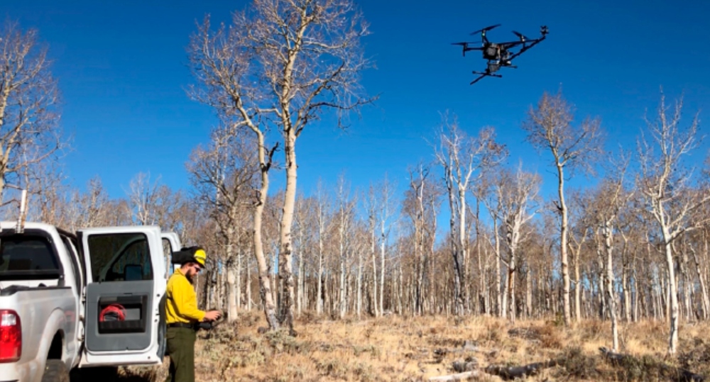
Photo credit: Fire Weather Research Laboratory
While DroneSeed is helping replant after wildfires, meteorological researchers have been working on using drones to predict the movements of wildfires so that firefighters can fight them more effectively.
Wildfires move erratically, which makes it hard to fight them. But using a drone equipped with a special sensor, researchers have been able to provide real-time meteorological data about active fires that can inform operations on the ground.
This application is still being researched, but presents a promising new way for firefighters to move more nimbly in their efforts to contain and fight ongoing fires.
4. Fighting the Spread of COVID-19
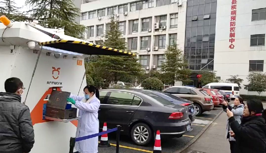
Photo credit: Antwork
Drones have been helpful in the effort to fight the spread of COVID-19 this year, primarily by supporting contactless delivery and by allowing public safety workers to spread messages to large groups of people (i.e., by using a drone as a flying loudspeaker).
Although the FAA declined to relax and/or fast-track drone delivery permissions this year, there were still several ways that drones were able to help fight the pandemic in the U.S. that didn’t necessarily require waivers or a Part 135 certificate for drone delivery.
One of the most recent stories about how drones are helping is by delivering COVID-19 test kits to people’s homes, removing yet one more possible contact point for those who worry they may have been infected, and thus helping to contain the spread of the virus.
5. Mapping, Detecting, and Detonating Landmines
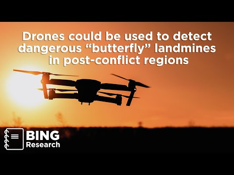
The Mine Kafon Drone (MKD) is a drone solution created specifically to find and detonate landmines.
Unexploded landmines in areas that were previously at war, as well as areas where there are active conflicts, kill people all the time. According to UNICEF, landmines are estimated to kill about 800 people a month, and they have exploded under around 1 million people since 1975.
In short, landmines are a major problem—one for which MKD has developed a drone solution. And MKD isn’t the only organization working to use drones in this novel way.
Researchers at Binghamton University are also working on an AI-powered landmine detection drone, which is featured in the video shown above.
6. Creating Art

Photo credit: Reuben Wu
While most of the drone applications on this list highlight concrete good work that drones can accomplish—like delivering medicine, or collecting crucial data for conservation efforts—drones were also used this year to create artwork that inspires and delights us.
In 2020, we were blown away by the work of Reuben Wu, who released a series of images he collectively called Light Storm. The pictures feature drones used as a light source to create halos and other beautiful, otherworldly patterns in the night sky (as in the image shown above).
You can see all of the pictures in Reuben’s series here.
7. Protecting the Ocean

Photo credit: NOAA
2020 was a big year for drones in oceanic research and conservation.
Why is that? Because this year the National Oceanic and Atmospheric Administration (NOAA) ramped up its drone program, which uses drones to study the ocean with the goal of helping to better protect it.
In March, NOAA established an Unmanned Systems Operations Program, and in April, they published the results of an extensive survey of right whales conducted with the support of UAS.
NOAA plans to continue expanding its use of drones in its research, and we’re sure to hear more about how UAVs are helping protect our oceans in the near future.
8. Supporting Investigations into Human Right Abuses

Human Rights Watch (HRW) partnered with Parrot this year to use drones to support an investigation into human rights abuses in Syria.
The video above documents the project, in which investigators used drones and mapping software to find the location of people killed by ISIS. The investigation started after HRW personnel found video evidence online that indicated there might be a mass grave in the al-Hota Gorge, located in northern Syria.
Using drones, investigators were able to find the site and gather conclusive evidence that human rights abuses had taken place.
Learn more about the al-Hota Gorge project and the other ways that drones have been used to support HRW’s investigations in this article.
9. Improving Our Ability to Predict Flash Floods

This year, climate researchers in Juneau, Alaska used drone technology to improve predictions of flash flooding in the area.
Researchers used the WingtraOne to help track the fluctuations of water and ice levels in the Suicide Basin, which helped them better predict the possibility of flash floods.
These predictions are crucial for the area, because a flood can take out the one road that connects those who live there with the only hospital in the area, isolating them and making it almost impossible to reach medical care in case of an emergency.
The Suicide Basin project is led by Gabriel Wolken, a research professor at the University of Alaska Fairbanks’ Climate Adaptation Science Center. Given its success thus far, it could provide a model for efforts to improve flash flooding predictions in other parts of the world.
10. Keeping Our Roads Safe by Fast-Tracking Accident Reconstruction

The first few minutes after an accident are incredibly dangerous.
The chances of another crash—called a secondary crash—happening near the site of a crash is higher than under normal circumstances, and that chance goes up by 3% for every minute the original crash site isn’t cleared.
Using drones, police officers have been able to dramatically reduce the amount of time it takes to collect the data they need for accident reconstruction, reducing it from a few hours down to just 10 minutes, in some cases.
The biggest story this year about drone adoption for crash scene investigations was in Montana (covered in the video above). The highway patrol there has a network of drones located throughout the state, which they use to collect accident reconstruction data so that roads can be cleared as quickly as possible following an accident.
11. Fighting Plastic Pollution throughout the World
Photo credit: United Nations Environment Program
This year we heard about researchers from Australia’s Commonwealth Scientific and Industrial Research Organisation (CSIRO) using drones on a massive project to survey plastic pollution in several key locations throughout the world.
The goal of the research is to use aerial data to create maps of some of the biggest rivers of the world and identify the plastic pollution found in them.
Since rivers feed into oceans, providing the pathway for much of the oceanic plastic pollution found in the world, these maps can be used to track the source and possible causes of plastic pollution.
Ultimately, the research may present a significant step forward in reducing plastic pollution throughout the world.


