How Are Drones Being Used on the Job Site? DroneII’s 2021 Report Looks at How Drone Applications Are Revolutionizing Business

BY Zacc Dukowitz
13 May 2021

A new report from Drone Industry Insights (DroneII) details the top ways that drones are being used for work today.

In addition to looking at the top commercial applications for drones overall, the report also looks closely at the top ways that different sectors use drones in their work, diving into the details of how industries like Energy and Construction are most commonly using drones on the job site.

drone-inspections-2021
Image credit: Flyability

One interesting finding from the report is that although drone applications are growing like crazy—the report includes 237 different ways that drones are currently being used for work—there are likely even more ways they could be used that just haven’t been thought of or tested yet.

A drone today is a bit like what a smartphone was just over a decade ago: a well-known device but widely underestimated in terms of innovation and business potential.

– DroneII 2021 Drone Applications Report

Findings from DroneII’s Report

This chart sums up the findings from DroneII’s industry applications report:

drone-applications-per-industry
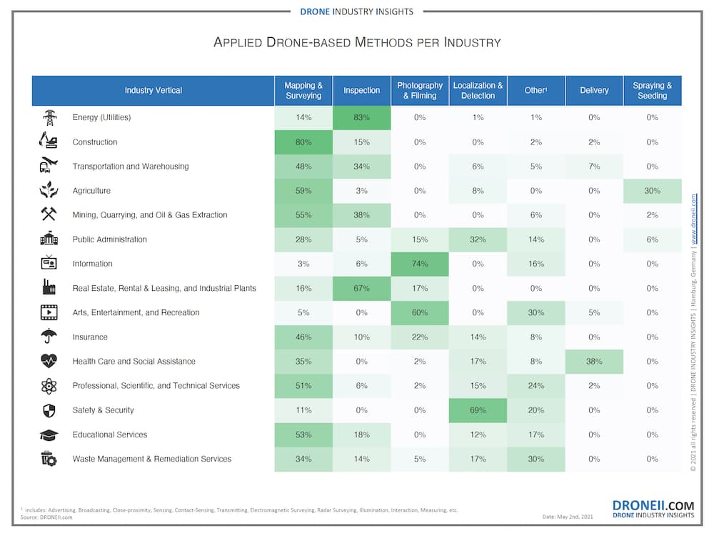
Image credit: DroneII

Here are our key takeaways from the data:

One Main Use Per Industry

Almost all industries are using drones primarily in just one way.

This could mean that a specific application is the best one for that industry or it could mean that new applications haven’t yet been developed. Either way, it’s interesting to see that most industries have honed in on a single use case—and this data could be gold for drone startups looking for promising new niches.

Mapping/Surveying and Inspections Dominate

The two biggest commercial uses for drones are mapping/surveying and inspections, with photography/filming a distant third.

This data turns the classic idea of drone work being primarily in aerial videography/photography on its head, showing that commercial drones have taken a firm position as tools for work.

Software Central to Drone Work

Software has a primary role in how drones are being used.

Although this finding isn’t explicitly present in the data, both mapping/surveying and inspections require post-processing and specialized software to create usable outputs from raw drone data.

And more drone-specific and industry-specific software is being released every day. Just a few weeks back, for example, Flyability released software made only for inspectors, which was made to help them pinpoint the location of defects found in the visual data they collect by drone.

. . . But a Drone Is Still Primarily a Flying Camera

We wouldn’t want to say a drone is “just” a flying camera—there are many different drones out there that provide different types and quality levels of visual data for different types of work.

Although these drones are used primarily to capture visual data—that is, they are still flying cameras—they have been created through years of deliberate research and are highly sophisticated pieces of equipment.

Of course, much of this visual data isn’t useful until it’s processed with specialized software, as noted above.

In some instances, the software is an important part of the visual data collection itself. For example, Drone Harmony’s Hill Scan flies a drone in a specific automated pattern over hilly and mountainous areas, optimizing the drone’s data collection for mapping these difficult types of terrain.

hill-scan-drone-harmoney
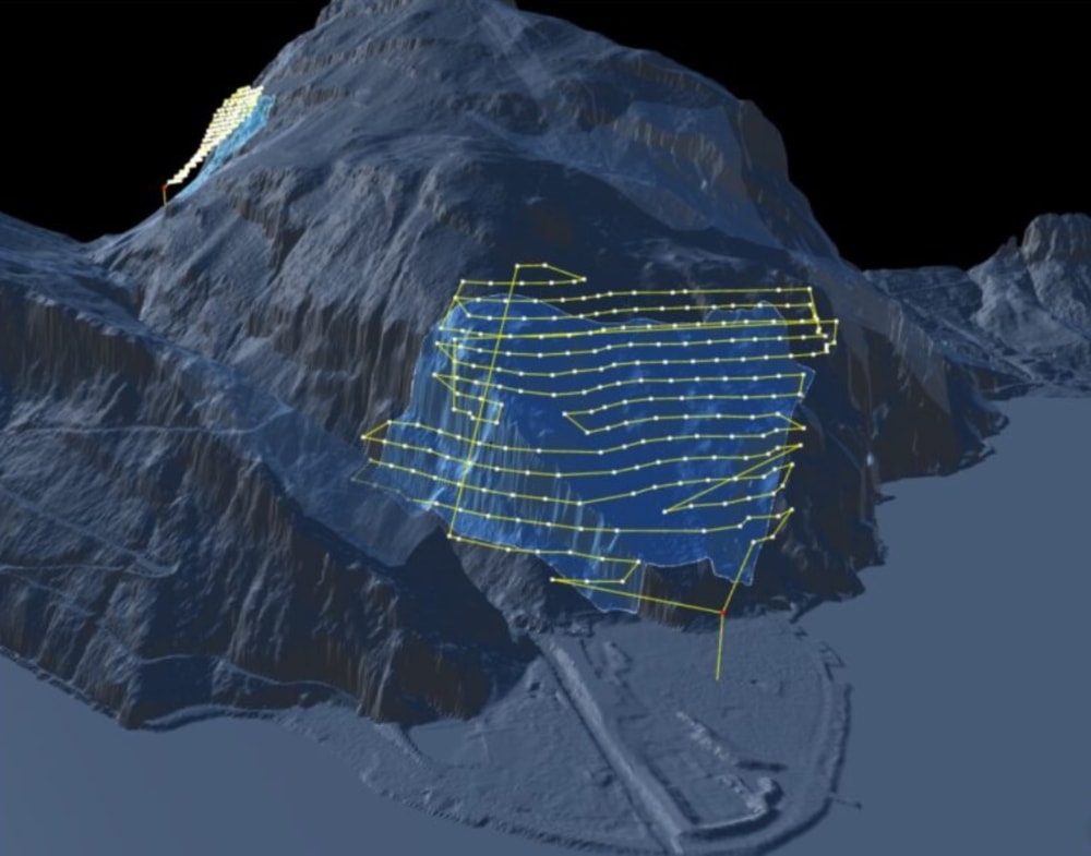
Image credit: Drone Harmony

What’s Next—Increased Specialization in Hardware and Software

While DJI continues to dominate the consumer drone market, we’ve seen some companies who focus on specific industries or use cases find a foothold and opportunities for growth.

elios-2-internal-inspections
Flyability’s Elios 2 being used to conduct an internal inspection

Examples of this approach include senseFly’s eBee Classic made just for mapping, Flyability’s Elios 2 made just for indoor inspections, and recent startups making drones focused on tasks as diverse as picking fruit, herding livestock, and detecting landmines.

All of these companies have carved out niches for themselves, as have several other UAVs focused on specific types of work.

And there are certainly more niches to be filled—in fact, the data in DroneII’s report could help guide emerging drone companies looking for a likely niche where a specific type of drone might be successful.

Along with new drones for specific niches, we’ll probably also see software made for specific types of work proliferate over the next several years. 3DR was one of the first companies to launch industry-specific software, with its Site Scan for construction work, but several others have come out since then.

In fact, in the coming years, it’s likely that commercial drone adoption may be driven as much by specialized software as by specialized hardware.

Join a global community of

100,000+

drone enthusiasts.

Subscribe

Drone Pilot's Guide to DJI Mini 4 Pro

  • Navigate the DJI Fly app and flight modes with ease
  • Adjust camera and safety settings for better control
  • Understand intelligent flight features and how to use them
  • Avoid common beginner mistakes
  • Get the most out of your drone—without the guesswork

Drone Pilot's Guide to DJI Air 3S

  • Navigate the DJI Fly app and flight modes with ease
  • Adjust camera and safety settings for better control
  • Understand intelligent flight features and how to use them
  • Avoid common beginner mistakes
  • Get the most out of your drone—without the guesswork

Hands-On Flight Training

$295

400+ 5-Star Reviews

  • Team up with a knowledgeable, friendly instructor at a convenient outdoor spot — like a park or athletic field
  • Fly a top-rated drone provided for you, or bring your own to get personalized guidance
  • Spend most of your time in the air with hands-on practice — learning about composition, camera angles and cinematic motion
  • Explore the DJI Fly app and learn how to use camera settings like ISO, shutter speed and aperture
  • Unlock the power of Intelligent Flight Modes to fly smoother, smarter, and with less stress
  • Get access to our Aerial Photo & Video online course with additional exercises and pro-level editing workflows – using Snapseed, Photopea, Adobe Lightroom, DJI LightCut, and Premiere Pro

Aerial Photo & Video for Drone Pilots

$179

3,500+ 5-Star Reviews

  • How to dial in the right camera settings like ISO, shutter speed, and aperture
  • The best angles & altitudes for different types of shots (real estate, landscapes, cityscapes, and more)
  • The secret to cinematic drone motion that makes your footage feel like a Hollywood movie
  • How to enhance colors, remove distractions, and sharpen details – even in tricky lighting
  • Pro-level editing workflows – whether you’re using Lightroom, free tools, or mobile apps

The Recreational UAS Safety Test

Free

150+ 5-Star Reviews

  • Required for U.S. recreational flyers of drones
  • Launched June 2021 by the FAA
  • Takes about 30 minutes to complete
  • No prior drone knowledge needed
  • Test allows unlimited attempts to pass

Drone Mapping Essentials Workshop

$799

3,500+ 5-Star Reviews

  • Expert instruction from expert drone pilots with over 100 hours of flying experience
  • Hands-on training of live data capture and how to process deliverables for your clients
  • Peer-to-peer networking with other professional drone pilots in the mapping industry
  • Free access to the online course, Drone Mapping Essentials

Flight Skills for Drone Pilots

$99

75+ 5-Star Reviews

  • 16 engaging video lectures with key takeaways
  • Action items with concrete steps so you put into practice what you learn
  • Pre-flight checklists to help you plan your flights
  • Resource links to websites, products and software for further learning and discovery

Drone Business & Mapping Bundle

$617 $397

3,500+ 5-Star Reviews

  • Drone Pilot Ground School
    1. 1:1 support with a Part 107 exam success coach
    2. Study 100% online at your own pace
    3. Unlimited practice exams with 400+ real FAA test questions
  • Drone Mapping Essentials
    1. 100+ instructional videos focused on real-world application with high-quality videos
    2. Downloadable resources like data capture checklists to utilize in your missions
    3. Monthly live instruction with course instructor, Dylan Gorman, to go deeper on topics where you need more clarification
  • The Drone Business Blueprint
    1. Expert instruction from industry veteran, Eno Umoh, who brings real-world experience in building successful drone businesses.
    2. 14 Comprehensive modules covering everything from business setup to marketing strategies
    3. 30 Downloadable resources to apply your learning immediately

Hands-On Flight Training

$295

400+ 5-Star Reviews

  • 45-60 minutes of hands-on flying time to master orientation and flight maneuvers tailored to your skill level
  • Learn how to handle obstacles such as lost GPS, low battery charge or emergencies
  • Practice flying under various intelligent flight modes
  • Ask questions about regulations, software, flight operations management, and more

The Drone Business Blueprint

$119

3,500+ 5-Star Reviews

  • Expert instruction from industry veteran, Eno Umoh, who brings real-world experience in building successful drone businesses.
  • 14 Comprehensive modules covering everything from business setup to marketing strategies
  • 30 Downloadable resources to apply your learning immediately
  • AI tools and techniques to boost productivity and streamline your operations

Commercial Drone Business Bundle

$418 $334

4,000+ 5-Star Reviews

  • Drone Pilot Ground School
    1. 1:1 support with a Part 107 exam success coach
    2. Study 100% online at your own pace
    3. Unlimited practice exams with 400+ real FAA test questions
  • The Drone Business Blueprint
    1. Expert instruction from industry veteran, Eno Umoh, who brings real-world experience in building successful drone businesses.
    2. 14 Comprehensive modules covering everything from business setup to marketing strategies
    3. 30 Downloadable resources to apply your learning immediately

Drone Mapping Essentials

$199

3,500+ 5-Star Reviews

  • 100+ instructional videos focused on real-world application with high-quality videos
  • Downloadable resources like data capture checklists to utilize in your missions
  • Quizzes to test your knowledge so you can succeed in the field
  • Monthly live instruction with course instructor, Dylan Gorman, to go deeper on topics where you need more clarification

Drone Pilot Pro Bundle

$713 $499

3,500+ 5-Star Reviews

  • Drone Pilot Ground School
    1. 1:1 support with a Part 107 exam success coach
    2. Study 100% online at your own pace
    3. Unlimited practice exams with 400+ real FAA test questions
  • Drone Pilot Skill Builder
    1. 16 engaging video lectures with key takeaways
    2. Action items with concrete steps so you put into practice what you learn
  • Hands-On Flight Training
    1. 45-60 minutes of hands-on flying time to master orientation and flight maneuvers tailored to your skill level

Drone Pilot Ground School

$299

4,000+ 5-Star Reviews

  • 1:1 support with a Part 107 exam success coach
  • Study 100% online at your own pace
  • Unlimited practice exams with 400+ real FAA test questions
  • Personalized study plans, virtual flashcards, and 12-page cram sheet
  • Weekly webinars on acing the Part 107 exam and monthly webinars to elevate your journey post-certification