Autonomous Wildfire Drone Can Fly through Smoke to Help Save Firefighters’ Lives

BY Zacc Dukowitz
15 May 2024

Drones were first introduced for use in firefighting about 13 years ago, at the 2011 Fire Department Instructors Conference (FDIC) International.

drones-firefighting
Credit: Skydio

At the time, using a drone to fight fires was a futuristic idea. Could drones really help fight fires, many wondered?

These days we know they can. In fact, drones are so important to firefighting operations that they’ve become commonplace.

Fire departments all over the country use drones regularly in their work, doing things like:

  • Visualizing a blaze in real time to fight it better
  • Locating victims in need of rescue using thermal imaging
  • Conducting post-fire investigations with 3D maps
  • Identifying hot spots using aerial thermography to determine whether a fire is still burning

faa-public-safety-drone-stats
Source: FAA

And FAA data shows drone use among public safety agencies (PSAs) to be growing rapidly, with estimates that the number of drones used by PSAs will be over 30,000 by 2025, representing a growth of 300% from the 10,000 in use in 2020.

Despite all the benefits drones provide firefighting operations, they still have a lingering limitation: They have to fly a safe distance above the fire.

But isn’t that true for all drones?

Not any more.

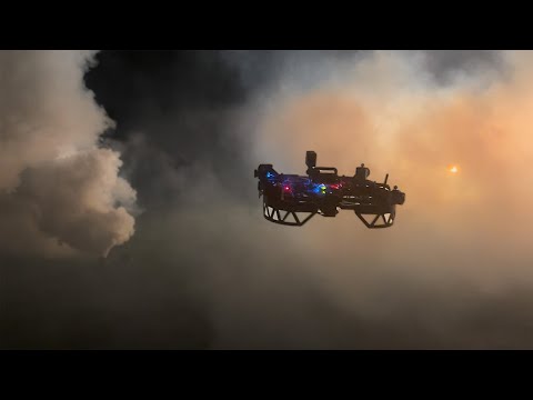
A Drone that Can Fly through Smoke

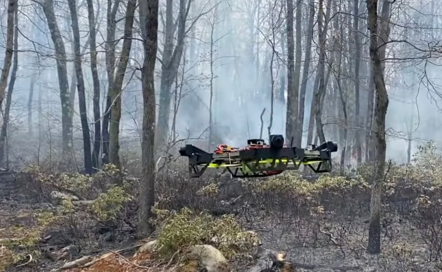
Researchers at Carnegie Mellon University have been working on a new type of firefighting drone that can fly close to the ground, allowing it to fly through the smoke and just above the treeline during a wildfire, or even below the canopy in some instances.

Autonomous Drones and AI for Wildfires : CMU Robotics Institute

This kind of drone opens up brand new use cases for drones in firefighting:

  • Mapping the fire on the ground, in and below the smoke
  • Visualizing the fire on the ground to plan for fighting it and to identify escape routes
  • Locating danger zones in the fire to support operations on the ground in real time

. . . drones used by those fighting wildfires are high-altitude aircraft that fly far above the trees. They can’t fly low because they can’t see through smoke. We want to fly just above the trees or even below the canopy.”

– Andrew Jong, PhD Student at Carnegie Mellon University

The Life-Saving Importance of Real-Time Information in Fighting Wildfires

Although drones have already proven to be incredibly useful for firefighting, they still can’t always provide real-time data. And the delay in getting information to firefighters can lead to lost lives.

That’s why the primary goal of the new CMU drone is to build a 3D model of an area impacted by wildfire as quickly as possible.

wildfire-drone-cmu

According to retired firefighter Josh Wilkins, a collaborator on the CMU project, firefighters are often given information that is 12 hours old.

“I helped bury too many folks who died for lack of actionable information,” says Wilkins, talking about the potential life-saving impact the new drone could have. In the 2013 Yarnell Hill Fire in Arizona, 19 firefighters died after a sudden change in the weather cut off their escape route, an awful event that underscores just how important real-time information is.

This new drone seems like it could help firefighters get this kind of crucial information. And it’s being developed at a critical time, when fires are increasing in number and intensity every single year across the globe.

How Does the Wildfire Drone Work?

To be effective, CMU researchers knew they needed a drone that could fly at high speed under the canopy without colliding with obstacles.

To avoid crashing, the wildfire drone does pathfinding while in flight, finding the best trajectories that will let the drone fly unimpeded while also letting it get the most data possible for 3D mapping.

Pathfinding is done by using data from a combination of radar, long-wave infrared, and visible light sensors and processing it with AI techniques, allowing the drone to fly autonomously around obstacles like branches or power lines that may be concealed by smoke.

Researchers are also using the same approach the drone uses to “see” through smoke and make its way around objects to create “de-smoked” 3D models, allowing you to clearly visualize an area or object in a 3D model.

desmoked-3d-model-cmu
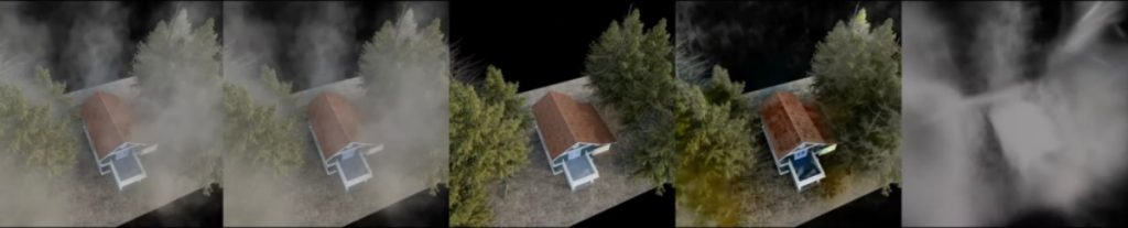
A desmoked 3D model | Credit: CMU

These 3D models can help firefighters quickly triage the structures in the path of a wildfire, allowing them to concentrate on the buildings with the best chance of being saved.

The key value is that the drone lets them make these decisions remotely, without having to endanger themselves to do an in-person assessment. The safety benefit here is akin to the benefit drones provide inspectors working in dangerous areas, like confined spaces, by eliminating the need for them to endanger themselves in order to collect inspection data.

The CMU drone was created based on research that went into the multi-year DARPA Subterranean Challenge, which involved multiple challenges for autonomous robotics operating in underground environments. It is also being developed with support from the U.S. Department of Agriculture and the National Science Foundation.

Join a global community of

100,000+

drone enthusiasts.

Subscribe

Drone Pilot's Guide to DJI Mini 4 Pro

  • Navigate the DJI Fly app and flight modes with ease
  • Adjust camera and safety settings for better control
  • Understand intelligent flight features and how to use them
  • Avoid common beginner mistakes
  • Get the most out of your drone—without the guesswork

Drone Pilot's Guide to DJI Air 3S

  • Navigate the DJI Fly app and flight modes with ease
  • Adjust camera and safety settings for better control
  • Understand intelligent flight features and how to use them
  • Avoid common beginner mistakes
  • Get the most out of your drone—without the guesswork

Hands-On Flight Training

$295

400+ 5-Star Reviews

  • Team up with a knowledgeable, friendly instructor at a convenient outdoor spot — like a park or athletic field
  • Fly a top-rated drone provided for you, or bring your own to get personalized guidance
  • Spend most of your time in the air with hands-on practice — learning about composition, camera angles and cinematic motion
  • Explore the DJI Fly app and learn how to use camera settings like ISO, shutter speed and aperture
  • Unlock the power of Intelligent Flight Modes to fly smoother, smarter, and with less stress
  • Get access to our Aerial Photo & Video online course with additional exercises and pro-level editing workflows – using Snapseed, Photopea, Adobe Lightroom, DJI LightCut, and Premiere Pro

Aerial Photo & Video for Drone Pilots

$179

3,500+ 5-Star Reviews

  • How to dial in the right camera settings like ISO, shutter speed, and aperture
  • The best angles & altitudes for different types of shots (real estate, landscapes, cityscapes, and more)
  • The secret to cinematic drone motion that makes your footage feel like a Hollywood movie
  • How to enhance colors, remove distractions, and sharpen details – even in tricky lighting
  • Pro-level editing workflows – whether you’re using Lightroom, free tools, or mobile apps

The Recreational UAS Safety Test

Free

150+ 5-Star Reviews

  • Required for U.S. recreational flyers of drones
  • Launched June 2021 by the FAA
  • Takes about 30 minutes to complete
  • No prior drone knowledge needed
  • Test allows unlimited attempts to pass

Drone Mapping Essentials Workshop

$799

3,500+ 5-Star Reviews

  • Expert instruction from expert drone pilots with over 100 hours of flying experience
  • Hands-on training of live data capture and how to process deliverables for your clients
  • Peer-to-peer networking with other professional drone pilots in the mapping industry
  • Free access to the online course, Drone Mapping Essentials

Flight Skills for Drone Pilots

$99

75+ 5-Star Reviews

  • 16 engaging video lectures with key takeaways
  • Action items with concrete steps so you put into practice what you learn
  • Pre-flight checklists to help you plan your flights
  • Resource links to websites, products and software for further learning and discovery

Drone Business & Mapping Bundle

$617 $397

3,500+ 5-Star Reviews

  • Drone Pilot Ground School
    1. 1:1 support with a Part 107 exam success coach
    2. Study 100% online at your own pace
    3. Unlimited practice exams with 400+ real FAA test questions
  • Drone Mapping Essentials
    1. 100+ instructional videos focused on real-world application with high-quality videos
    2. Downloadable resources like data capture checklists to utilize in your missions
    3. Monthly live instruction with course instructor, Dylan Gorman, to go deeper on topics where you need more clarification
  • The Drone Business Blueprint
    1. Expert instruction from industry veteran, Eno Umoh, who brings real-world experience in building successful drone businesses.
    2. 14 Comprehensive modules covering everything from business setup to marketing strategies
    3. 30 Downloadable resources to apply your learning immediately

Hands-On Flight Training

$295

400+ 5-Star Reviews

  • 45-60 minutes of hands-on flying time to master orientation and flight maneuvers tailored to your skill level
  • Learn how to handle obstacles such as lost GPS, low battery charge or emergencies
  • Practice flying under various intelligent flight modes
  • Ask questions about regulations, software, flight operations management, and more

The Drone Business Blueprint

$119

3,500+ 5-Star Reviews

  • Expert instruction from industry veteran, Eno Umoh, who brings real-world experience in building successful drone businesses.
  • 14 Comprehensive modules covering everything from business setup to marketing strategies
  • 30 Downloadable resources to apply your learning immediately
  • AI tools and techniques to boost productivity and streamline your operations

Commercial Drone Business Bundle

$418 $334

4,000+ 5-Star Reviews

  • Drone Pilot Ground School
    1. 1:1 support with a Part 107 exam success coach
    2. Study 100% online at your own pace
    3. Unlimited practice exams with 400+ real FAA test questions
  • The Drone Business Blueprint
    1. Expert instruction from industry veteran, Eno Umoh, who brings real-world experience in building successful drone businesses.
    2. 14 Comprehensive modules covering everything from business setup to marketing strategies
    3. 30 Downloadable resources to apply your learning immediately

Drone Mapping Essentials

$199

3,500+ 5-Star Reviews

  • 100+ instructional videos focused on real-world application with high-quality videos
  • Downloadable resources like data capture checklists to utilize in your missions
  • Quizzes to test your knowledge so you can succeed in the field
  • Monthly live instruction with course instructor, Dylan Gorman, to go deeper on topics where you need more clarification

Drone Pilot Pro Bundle

$713 $499

3,500+ 5-Star Reviews

  • Drone Pilot Ground School
    1. 1:1 support with a Part 107 exam success coach
    2. Study 100% online at your own pace
    3. Unlimited practice exams with 400+ real FAA test questions
  • Drone Pilot Skill Builder
    1. 16 engaging video lectures with key takeaways
    2. Action items with concrete steps so you put into practice what you learn
  • Hands-On Flight Training
    1. 45-60 minutes of hands-on flying time to master orientation and flight maneuvers tailored to your skill level

Drone Pilot Ground School

$299

4,000+ 5-Star Reviews

  • 1:1 support with a Part 107 exam success coach
  • Study 100% online at your own pace
  • Unlimited practice exams with 400+ real FAA test questions
  • Personalized study plans, virtual flashcards, and 12-page cram sheet
  • Weekly webinars on acing the Part 107 exam and monthly webinars to elevate your journey post-certification