

The Vantis Network—North Dakota’s Progress toward Creating a Statewide System for Flying BVLOS
BY Zacc Dukowitz
20 May 2021North Dakota has been working for some time to create a statewide BVLOS (Beyond Visual Line of Sight) network.
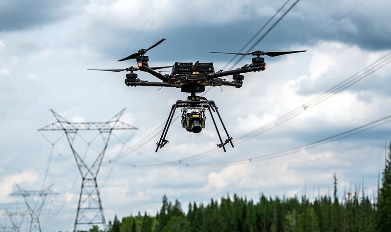
Photo credit: Vantis
The name of the North Dakota network is Vantis and it’s being developed in full partnership with the FAA. For the most part, that partnership work is being done under the aegis of the FAA’s BEYOND program, which has an explicit goal of making BVLOS operations mainstream.
The partnership is significant, because it means that as the technology and infrastructure of the network is developed it is also being held to FAA safety standards, setting North Dakota up for fast-tracked approvals when the network is ready to go live.
A similar approach was taken by Wing to get its drone delivery program launched in Christiansburg, Virginia, with the company conducting exhaustive tests as part of the FAA’s UAS IPP (Integration Pilot Program)—the precursor to the BEYOND program—until ultimately getting approval to start the first consumer drone delivery program in the country.
If Vantis is successfully launched and the entire state of North Dakota becomes a place where drone pilots can fly BVLOS without the need for special waivers or permissions from the FAA, the network could well become the go-to model adopted by other states, and even other countries.
We are going to be able to figure out how we can do this type of integration, what tools are needed, and the types of challenges that present themselves, and that is going to help a lot of other people replicate this process.
– Nick Flom, Executive Director of the Northern Plains UAS Test Site
How the Vantis Network Supports BVLOS Operations
The current path to getting permission to fly BVLOS from the FAA requires exhaustive testing of the proposed drone and supporting equipment in the specific proposed operational conditions in order to demonstrate that all safety concerns have been anticipated and addressed.
Vantis seeks to address the safety concerns associated with BVLOS operations in a different way, by creating a statewide network that will ensure drones don’t crash into manned aircraft.
To do this, Vantis plans to modify existing infrastructure, allowing commercial drone pilots to use aviation and surveillance technology that is already in place in North Dakota in order to make sure they can safely fly beyond the pilot’s line of sight.
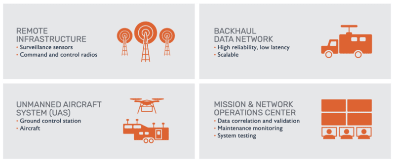
Photo credit: Vantis
The goal for this approach is to create a way for commercial drone pilots to fly BVLOS that is replicable, scalable, and economic—that is, something that any drone pilot could use, regardless of their ability to access the resources that might be available to big companies.
What we are really trying to accomplish is to lower the barrier for advanced UAS operations into a single network that multiple users can take advantage of to meet their needs to fly beyond visual line of sight.
Nick Flom, Executive Director of the Northern Plains UAS Test Site
In addition to setting up the infrastructure, Vantis personnel are working to secure all the permissions needed from the FAA to operate BVLOS. If they can demonstrate that the network is safe through repeated testing, the hope is that they can get permission to launch the network.
Why BVLOS Is So Important
But why should we care about being able to fly BVLOS?
Because it could open up new drone applications and significantly expand existing ones. If flying BVLOS became normalized, several industries that currently use drones in a fairly minor capacity might suddenly adopt them at a much larger scale.
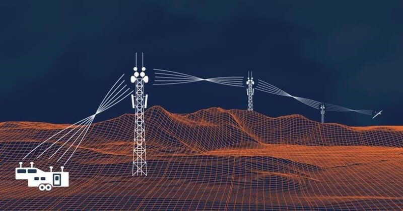
Photo credit: Vantis
Although a handful of applications have been developed that use drones to actually do a job, like dropping seeds to plant trees or dropping water to fight fires, the most common use for drones is data collection.
For inspections, drones typically use cameras to collect visual data so that inspectors can review it to assess the condition of industrial assets, looking for potential flaws and defects that may require maintenance.
For agriculture, drones can be equipped with multispectral cameras to calculate the vegetation index of crops in order to determine their health. And for land surveying, a drone can be equipped with a LiDAR sensor to create an accurate 3D map of an area.
More and more sensors are being developed for drones all the time, and more and more use cases are being found for existing sensors.
But drone adoption has flagged in many industries because all this data collection is limited to the physical location of the pilot.
If a drone could fly longer distances on automated data collection routes, there could be a huge potential benefit for the inspection of pipelines, railways, powerlines, and other sprawling infrastructure, as well as for the management of vast fields of crops in agriculture.
We’re seeing incremental steps that are already making a difference. We’ve been able to demonstrate operations with precision agriculture flying at 15,000 feet doing 10,000 plus acres an hour. With the IPP program, and now the Beyond program, we are able to put this system in place with the support of our state.
– Nick Flom, Executive Director of the Northern Plains UAS Test Site
Drone delivery is another obvious application that would benefit from the ability to fly BVLOS, as is security, which could use automated flights to collect visual data around the perimeter of a factory or in other sensitive areas.
And this is why BVLOS is so important.
If industries can fly beyond the pilot’s visual line of sight, their ability to collect the data they need to do their work will skyrocket—and so will drone adoption, according to many in the industry.
Right now, the process to get BVLOS approval is complicated and expensive, and not at all scalable. But if a network like Vantis can make flying BVLOS commonplace, the entire drone industry could be transformed, as could the industries that benefit from drones.
While it’s easy to get carried away daydreaming about the great things that BVLOS may someday bring about in the industry, the reality is that the Vantis network is real and is making significant strides towards its goal.
And if things stay on track with testing, we may soon see regular BVLOS operations begin throughout the state of North Dakota.
Excited for the Vantis network to go live? Share your thoughts in this thread on the UAV Coach community forum.


