The Future of Urban Drone Operations—FAA Completes Phase 2 of UTM Testing + Airspace Link’s Drone Highways Help Expand Drone Operations in Cities

BY Zacc Dukowitz
3 December 2020

Today we’re covering two recent stories about technology that’s pushing forward the possibilities for urban drone operations—the FAA’s completion of Phase 2 testing for UTM (Unmanned Traffic Management) and the adoption of Airspace Link’s digital “drone highways” throughout the U.S.
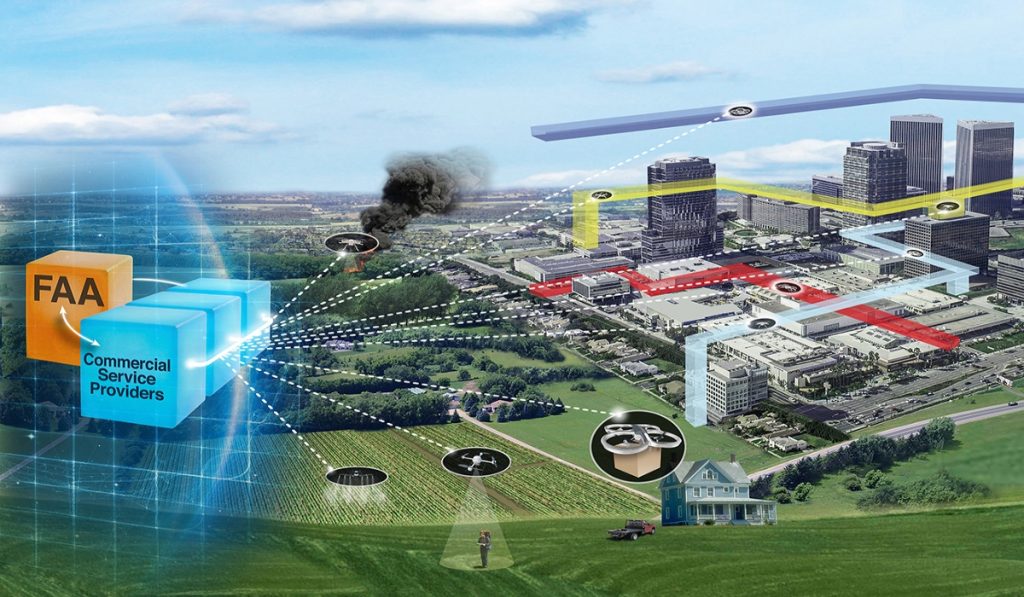
nasa-faa-utm
Image credit: NASA

FAA Completes Phase 2 Testing for UTM

As the final step in the FAA’s recent Phase 2 of UTM testing, two demonstrations were recently performed involving over 100 participants.

Those involved included local and state elected officials, private companies, representatives from international civil aviation authorities, drone operators, and local public safety agencies.

The demonstrations will help move us closer to safe beyond-visual-line-of-sight drone operations. Flight testing UTM capabilities in high-density airspace will help us develop policy for safely and efficiently integrating drones into our national airspace while benefiting and serving communities.

– Pamela Whitley, Acting Assistant Administrator for FAA’s NextGen Program

The tests focused on demonstrations of scenarios that featured various complex UTM capabilities, working in coordination to support BVLOS operations with increasing volumes and densities.

Specifically, tests showcased:

  • Data and technologies for remote ID standards
  • Drone volume reservations to notify drone operators of emergencies
  • The capabilities of secure information exchange technology (testing communications between the FAA, private companies, and authorized users)

The two demonstrations were performed at two UAS test sites: the Virginia Tech Mid-Atlantic Aviation Partnership (MAAP) and the New York UAS Test Site (NYUASTS).

Here is a video showcasing clips from the demonstrations:

UPP 2 Demos – VA Tech and Rome, NY

100 participants is a huge number, and indicates just how complex—and how advanced—the FAA’s UTM testing has become.

And there’s a reason for that.

NASA is an acting partner with the FAA in these tests, and before the FAA began its own UTM testing earlier this year, NASA had already completed four distinct testing phases of its own.

So, in a way, the FAA’s Phase 2 of UTM testing could be seen as Phase 6 (though this is a little simplistic, of course).

[Related reading: NASA Will Test Drone Traffic Management Systems in U.S. Cities as Final Phase of UTM Project]

This is all to say that, as indicated by the complexity of the demonstrations and the number of stakeholders involved, that UTM technology has come a long way.

Of course, a missing piece of the UTM puzzle is still an established Remote ID rule—but it looks like that new rule, for better or worse, will be released fairly soon.

What Is UTM Exactly?

The phrase Unmanned Traffic Management could indicate a lot of different activities, as you can see just by looking at the list of things the FAA tested in Phase 2 above.

Here’s how the FAA defines the phrase UTM on its UTM Pilot Program Page:

Unmanned Aircraft System Traffic Management (UTM) is a “traffic management” ecosystem for uncontrolled operations that is separate from, but complementary to, the FAA’s Air Traffic Management (ATM) system. UTM development will ultimately identify services, roles and responsibilities, information architecture, data exchange protocols, software functions, infrastructure, and performance requirements for enabling the management of low-altitude uncontrolled drone operations.

Airspace Link’s Drone Highways

Along with the news about the FAA’s recent UTM demonstrations, Airspace Link’s partnership with the city of Ontario, CA presents another recent story showcasing the progress being made for urban drone operations.

airspace-link
Photo credit: Airspace Link

Airspace Link helps state and local governments create drone highways, which are essentially safe flight corridors for drone operations in what might otherwise be a densely populated area.

If you were to set up these drone highways, it’s really about figuring out the safest areas for the kind of drone I’m going to fly and figuring out the probability of hurting someone on the ground in creating these corridors.

– Michael Healander, President and CEO of Airspace Link

This month, Detroit-based Airspace Link announced its partnership with the city of Ontario. The goal of the partnership is to establish the first drone highways in the state of California, using Airspace Link’s AirHub for Government platform.

The AirHub system pulls in a city’s GIS (Geographic Information Systems) data, including information on the locations of places like jails, schools, and hospitals, and combines it with FAA information on restricted and prohibited airspace in order to identify the safest areas for drone operations in the area.

This approach can potentially open up new areas for drone operations.

By working in partnership with the FAA and the Ontario International Airport, Airspace Link was able to identify almost twenty square miles that could potentially be used for drone traffic—an area that hadn’t previously been available for drone operations.

Here are some of the major benefits to the AirHub system for a city like Ontario:

  • Drone operators can clearly understand where they can and can’t fly
  • New areas are potentially opened up for drone operations (as described above), which might otherwise require airspace authorization or simply be prohibited from use altogether
  • The city can issue notifications to drone pilots about temporary situations that impact drone operations, which work just like TFRs (Temporary Flight Restrictions) issued by the FAA

Further, drone pilots can use the data collected by the city and AirHub to support their waiver applications for BVLOS and other operations generally prohibited by the FAA’s Part 107 rules.

This data could potentially have a big impact in securing positive outcome for waiver applications, since it could address one of the FAA’s primary concerns when issuing Part 107 waivers—safety considerations about the proposed operation(s).

And Ontario isn’t the only place that’s adopting Airspace Link’s systems to help support the growth of urban drone operations.

It is working with the entire state of North Dakota in its ambitious plans to create a statewide BVLOS network, and the company is also reportedly working with over 300 customers, including a mix of pilots, state and local governments, and private businesses throughout the U.S.

Excited about these developments? Share your thoughts in this thread on the UAV Coach community forum.

Join a global community of

100,000+

drone enthusiasts.

Subscribe

Drone Pilot's Guide to DJI Mini 4 Pro

  • Navigate the DJI Fly app and flight modes with ease
  • Adjust camera and safety settings for better control
  • Understand intelligent flight features and how to use them
  • Avoid common beginner mistakes
  • Get the most out of your drone—without the guesswork

Drone Pilot's Guide to DJI Air 3S

  • Navigate the DJI Fly app and flight modes with ease
  • Adjust camera and safety settings for better control
  • Understand intelligent flight features and how to use them
  • Avoid common beginner mistakes
  • Get the most out of your drone—without the guesswork

Hands-On Flight Training

$295

400+ 5-Star Reviews

  • Team up with a knowledgeable, friendly instructor at a convenient outdoor spot — like a park or athletic field
  • Fly a top-rated drone provided for you, or bring your own to get personalized guidance
  • Spend most of your time in the air with hands-on practice — learning about composition, camera angles and cinematic motion
  • Explore the DJI Fly app and learn how to use camera settings like ISO, shutter speed and aperture
  • Unlock the power of Intelligent Flight Modes to fly smoother, smarter, and with less stress
  • Get access to our Aerial Photo & Video online course with additional exercises and pro-level editing workflows – using Snapseed, Photopea, Adobe Lightroom, DJI LightCut, and Premiere Pro

Aerial Photo & Video for Drone Pilots

$179

3,500+ 5-Star Reviews

  • How to dial in the right camera settings like ISO, shutter speed, and aperture
  • The best angles & altitudes for different types of shots (real estate, landscapes, cityscapes, and more)
  • The secret to cinematic drone motion that makes your footage feel like a Hollywood movie
  • How to enhance colors, remove distractions, and sharpen details – even in tricky lighting
  • Pro-level editing workflows – whether you’re using Lightroom, free tools, or mobile apps

The Recreational UAS Safety Test

Free

150+ 5-Star Reviews

  • Required for U.S. recreational flyers of drones
  • Launched June 2021 by the FAA
  • Takes about 30 minutes to complete
  • No prior drone knowledge needed
  • Test allows unlimited attempts to pass

Drone Mapping Essentials Workshop

$799

3,500+ 5-Star Reviews

  • Expert instruction from expert drone pilots with over 100 hours of flying experience
  • Hands-on training of live data capture and how to process deliverables for your clients
  • Peer-to-peer networking with other professional drone pilots in the mapping industry
  • Free access to the online course, Drone Mapping Essentials

Flight Skills for Drone Pilots

$99

75+ 5-Star Reviews

  • 16 engaging video lectures with key takeaways
  • Action items with concrete steps so you put into practice what you learn
  • Pre-flight checklists to help you plan your flights
  • Resource links to websites, products and software for further learning and discovery

Drone Business & Mapping Bundle

$617 $397

3,500+ 5-Star Reviews

  • Drone Pilot Ground School
    1. 1:1 support with a Part 107 exam success coach
    2. Study 100% online at your own pace
    3. Unlimited practice exams with 400+ real FAA test questions
  • Drone Mapping Essentials
    1. 100+ instructional videos focused on real-world application with high-quality videos
    2. Downloadable resources like data capture checklists to utilize in your missions
    3. Monthly live instruction with course instructor, Dylan Gorman, to go deeper on topics where you need more clarification
  • The Drone Business Blueprint
    1. Expert instruction from industry veteran, Eno Umoh, who brings real-world experience in building successful drone businesses.
    2. 14 Comprehensive modules covering everything from business setup to marketing strategies
    3. 30 Downloadable resources to apply your learning immediately

Hands-On Flight Training

$295

400+ 5-Star Reviews

  • 45-60 minutes of hands-on flying time to master orientation and flight maneuvers tailored to your skill level
  • Learn how to handle obstacles such as lost GPS, low battery charge or emergencies
  • Practice flying under various intelligent flight modes
  • Ask questions about regulations, software, flight operations management, and more

The Drone Business Blueprint

$119

3,500+ 5-Star Reviews

  • Expert instruction from industry veteran, Eno Umoh, who brings real-world experience in building successful drone businesses.
  • 14 Comprehensive modules covering everything from business setup to marketing strategies
  • 30 Downloadable resources to apply your learning immediately
  • AI tools and techniques to boost productivity and streamline your operations

Commercial Drone Business Bundle

$418 $334

4,000+ 5-Star Reviews

  • Drone Pilot Ground School
    1. 1:1 support with a Part 107 exam success coach
    2. Study 100% online at your own pace
    3. Unlimited practice exams with 400+ real FAA test questions
  • The Drone Business Blueprint
    1. Expert instruction from industry veteran, Eno Umoh, who brings real-world experience in building successful drone businesses.
    2. 14 Comprehensive modules covering everything from business setup to marketing strategies
    3. 30 Downloadable resources to apply your learning immediately

Drone Mapping Essentials

$199

3,500+ 5-Star Reviews

  • 100+ instructional videos focused on real-world application with high-quality videos
  • Downloadable resources like data capture checklists to utilize in your missions
  • Quizzes to test your knowledge so you can succeed in the field
  • Monthly live instruction with course instructor, Dylan Gorman, to go deeper on topics where you need more clarification

Drone Pilot Pro Bundle

$713 $499

3,500+ 5-Star Reviews

  • Drone Pilot Ground School
    1. 1:1 support with a Part 107 exam success coach
    2. Study 100% online at your own pace
    3. Unlimited practice exams with 400+ real FAA test questions
  • Drone Pilot Skill Builder
    1. 16 engaging video lectures with key takeaways
    2. Action items with concrete steps so you put into practice what you learn
  • Hands-On Flight Training
    1. 45-60 minutes of hands-on flying time to master orientation and flight maneuvers tailored to your skill level

Drone Pilot Ground School

$299

4,000+ 5-Star Reviews

  • 1:1 support with a Part 107 exam success coach
  • Study 100% online at your own pace
  • Unlimited practice exams with 400+ real FAA test questions
  • Personalized study plans, virtual flashcards, and 12-page cram sheet
  • Weekly webinars on acing the Part 107 exam and monthly webinars to elevate your journey post-certification