

Drones at Night: How to Spot a Drone at Night, Drone Lights & More
BY Zacc Dukowitz
17 February 2026Wondering how to spot a drone at night?
It’s not always as easy as it seems.
Toward the end of 2024, we saw mass hysteria spread in New Jersey and surrounding states when people thought they were seeing dozens of drones flying at night. In fact, as we learned once the dust settled and the sightings died down, most of the sightings were of crewed aircraft—not drones at night.

The truth is that, at night, even seasoned drone pilots can have trouble distinguishing drones from other aircraft.
At the same time, night operations are becoming more and more common. Law enforcement, public safety, industrial inspections, and aerial cinematography all fly drones at night more often now than five or even just a few years ago.
Recreational pilots also fly after dark, especially since the FAA updated Part 107 rules in 2021 to allow routine night flights with anti-collision lighting.
At the same time, privacy and safety concerns remain, especially when reports of surveillance drones at night surface in news feeds. Knowing what drones look like at night—and how to differentiate them from other things in the sky—is an important skill for both pilots and the general public.
This guide breaks down the visual and acoustic signatures of drones at night, the technology available for drone detection, and the rules that shape night operations. We also cover how to separate drones from airplanes, helicopters, satellites, and stars, and which tools or apps can (and can’t) help you confirm what you’re seeing.
Want to jump around? Here’s a menu to help you find what you’re looking for:
- How to Spot a Drone at Night
- How to Tell the Difference Between a Drone and Other Nighttime Objects
- Why Drones Fly at Night
- Technology for Detecting Drones at Night
- FAA Requirements for Nighttime Drone Operations
- Safety, Privacy, and Other Legal Considerations
- Drones at Night FAQ
Quick Checklist: How to Spot a Drone at Night
- ✅ Look for tightly clustered lights with a bright white strobe pulsing at intervals.
- ✅ Check colors and spacing: red on left, green on right, white orientation light; all packed close to the airframe.
- ✅ Listen for a high-pitched electric whir that fades within a few hundred feet.
- ✅ Watch movement: precise hovering, short accelerations, quick yaw turns, stepwise climbs.
- ✅ Observe for 30–60 seconds; patterns reveal themselves quickly.
- ✅ Record brief video on your phone to review lights, motion, and timing.
- ✅ Compare against look-alikes: airplanes move smoothly with wide light spacing; stars twinkle but stay put; satellites glide silently in straight lines.
- ✅ If near public safety activity, expect deliberate loitering or orbits and occasional spotlight use.
- ✅ Use apps as hints only; confirm with lights, sound, and motion.
- ✅ If you’re unsure how to spot a drone at night, stand still, reduce background noise, and re-observe from a darker vantage.
If you’re still uncertain, wait a minute and recheck direction, altitude, and sound.
How to Spot a Drone at Night
Identifying a drone in the dark isn’t always easy, but there are clear signals you can use.
When you combine the observation of lights, sound, and movement patterns, you can usually spot a drone at night with a good degree of confidence.
Let’s look closer at each of these.
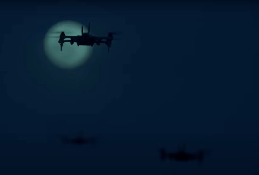
The Teal 2 drone flying at night
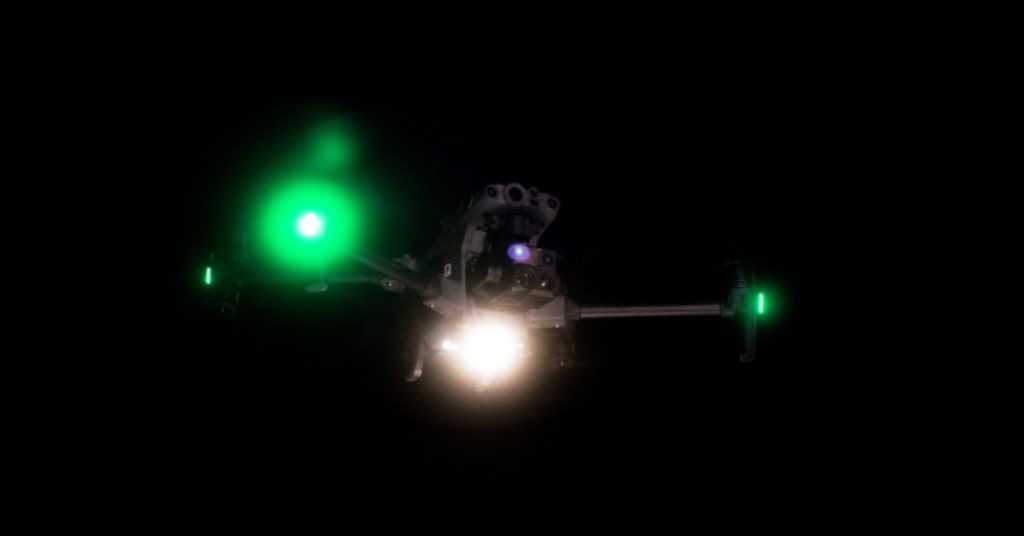
1. Lights on a Drone at Night
The easiest way to confirm a drone after dark is by its lights. Most drones combine navigation LEDs with a bright anti-collision strobe, and knowing how these work makes identification much easier.
Navigation lights follow aviation convention:
- Red on the port (left) side
- Green on the starboard (right) side
- White facing forward or aft as an orientation light
Unlike airplanes, where these lights are spread far apart on the wings and tail, drones cluster them tightly together around the body or arms. That compact spacing is one of the quickest giveaways.
Since 2021, FAA rules require Part 107 pilots flying at night to equip anti-collision lighting visible from at least three statute miles away. These lights usually appear as intense white strobes flashing at regular intervals. Many recreational pilots also add aftermarket strobes, which can be mounted on top or bottom of the aircraft, so you may see unusual placement or extra colors beyond the standard red, green, and white.
What do drones look like at night? Typically a small, concentrated group of lights—often with a sharp white flash from the strobe—that hovers or moves in short, deliberate bursts. Airplanes, by comparison, show a broader light signature moving smoothly across the sky, while stars and planets twinkle but stay fixed in place.
2. The Sound of a Drone
Multirotors generate a high-pitched buzzing or humming from their propellers.
Helicopters produce a deeper rotor thump that carries farther, while satellites and stars make no sound at all.
Higher-end aircraft like the DJI Mavic 3 or Skydio X10 Enterprise may fly more quietly, but within a few hundred feet you’ll still hear the electric whir.
3. Drone Movement Patterns
Drones can hover precisely, then make sudden, deliberate moves—short accelerations, quick yaws, or stepwise climbs.
Survey or SAR flights may trace grid lines or orbit a target, pausing to hover at intervals.
If you’re asking how to spot a police drone at night, look for persistent loitering over one area, repeated repositioning, and spotlight or thermal use.
Taken together—compact lights with a bright strobe, a close-in whir, and crisp, deliberate movement—these cues make drones at night easier to confirm.
If you’re unsure, observe for 30–60 seconds; flight patterns usually reveal themselves quickly.
How to Tell the Difference Between a Drone and Other Nighttime Objects
Not everything you see in the night sky is a drone. Airplanes, satellites, helicopters, and even bright stars can look deceptively similar at first glance. With a little observation, though, the differences become clear.
| Object | What You’ll See | How It Differs from a Drone |
|---|---|---|
| Airplane | Wide spread of red, green, and white lights; smooth, steady motion across the sky | Lights spread far apart, continuous forward flight; no hovering or sharp repositioning |
| Helicopter | Bright navigation lights, often with a spotlight; deeper rotor sound | Larger light signature, slower forward motion, and a heavy “thump” rather than a high-pitched whir |
| Satellite | Small, steady point of light gliding silently in a straight line | Predictable track, no hovering or sudden changes, completely silent |
| Star or Planet | Bright, twinkling light fixed in the same position throughout the night | Stationary, no sound, and twinkles; drones shift position or flash strobes |
Here’s a little more information about each of the other nighttime objects covered in the chart above, and how to tell the difference between them and a drone:
Drones vs. Airplanes
Airplanes typically cruise at higher altitudes with navigation lights spread across the wings and tail. Their motion is smooth and steady, moving forward without sudden stops. Drones, by contrast, show tightly clustered lights and can hover or pivot abruptly.
Drones vs. Helicopters
Helicopters use bright navigation lights and often carry spotlights for ground illumination. Their rotor sound is low and thumping, carrying long distances. Multirotor drones have a compact light pattern and produce a higher-pitched buzzing sound that fades quickly with distance.
Drones vs. Satellites
Satellites appear as small, steady points of light moving silently across the sky in straight lines. They never stop or change course suddenly. Drones, on the other hand, can strobe, hover, or backtrack—behaviors satellites can’t replicate.
Drones vs. Stars or Planets
Stars and planets remain fixed relative to the horizon, twinkling as their light passes through the atmosphere. They don’t move or make sound over short observation periods. Drones can mimic stars at first glance, but after 30–60 seconds, hovering, strobes, or movement reveal them as aircraft.
Why Drones Fly at Night
Seeing lights suspended over a neighborhood or job site can feel unusual, but drones at night are often on legitimate missions. Understanding the context helps frame what you’re observing.
Police in Sussex, U.K. flying a drone at night
1. Police and Public Safety
Agencies deploy enterprise drones after dark for scene awareness, documentation, and rapid search in conditions where helicopters are costly or impractical. Flights are deliberate: hovering over points of interest, orbiting perimeters, and coordinating with ground units.
Common uses of drones at night for Police and Public Safety include:
- Searches for missing or fleeing persons using thermal and high-zoom cameras
- Crash and crime scene documentation with photo/video and mapping
- Perimeter overwatch and crowd monitoring at events or incidents
- Spotlight-assisted area scans and officer safety support
- Disaster response situational awareness (downed power lines, blocked roads)
2. Search and Rescue
SAR teams run methodical grid patterns with thermal sensors to find heat signatures in low light, dense brush, or rugged terrain. Aircraft loiter over promising hits and guide ground teams to precise locations.
Common uses of drones at night for Search and Rescue include:
- Thermal-based searches for lost hikers or vulnerable individuals
- Post-disaster recon to identify safe routes and hazards
- Guiding responders with visible spotlights or waypoint lighting
- Dropping visual markers or broadcasting location data for teams
3. Commercial and Industrial Work
Utilities and inspection crews schedule night operations to avoid daytime shutdowns and reduce risk around energized or busy assets. Cinematography teams also work after dark to capture cityscapes and controlled lighting effects.
Common uses of drones at night for Commercial and Industrial work include:
- Power line, substation, and flare/stack inspections with thermal
- Tank, tower, and bridge checks during low-traffic windows
- Emergency outage assessment and damage triage
- Construction progress and security patrols after hours
- Film and TV aerials requiring nighttime scenes
4. Recreational and Hobby Flights
Recreational pilots sometimes fly at night for low-light photography practice or to evaluate lighting kits and strobes. These flights are typically short and local, with the aircraft hovering near launch points.
Common uses of drones at night for Recreational and Hobby pilots include:
- Night photography and cityscape timelapses
- Testing anti-collision strobes and navigation lighting
- Light-painting and long-exposure effects
- Skill practice in well-lit, open areas under CBO guidelines
5. Firefighting and Emergency Response
Drones support firefighters at night by locating hotspots, mapping fire edges, and providing safer, faster situational awareness when smoke and darkness limit visibility. Thermal payloads help incident commanders prioritize resources and verify knockdown without sending crews into hazardous areas.
Common uses of drones at night for Firefighting and Emergency Response include:
- Thermal hotspot detection and overhaul verification
- Perimeter mapping and live overwatch for advancing or wind-driven fires
- Hazardous materials assessment and plume monitoring
- Structure triage and access planning for crews
- Search of collapsed or compromised structures after disasters
6. Military and Defense
Military and defense organizations conduct nighttime reconnaissance and security missions with both multirotor and fixed-wing systems. These aircraft often fly higher, stay aloft longer, and carry advanced sensors that enable covert observation and wide-area monitoring.
Common uses of drones at night for Military and Defense include:
- Persistent ISR with electro-optical and thermal sensors
- Force protection and base perimeter overwatch
- Route reconnaissance and convoy support
- Maritime domain awareness and coastal patrols
- Target acquisition and damage assessment
7. Environmental and Wildlife Monitoring
Researchers and conservation teams use drones after dark to study nocturnal species and detect human activity that threatens wildlife. Thermal imaging enables low-disturbance surveys, while night flights reduce heat shimmer and improve contrast on animals and terrain.
Common uses of drones at night for Environmental and Wildlife Monitoring include:
- Counting and tracking nocturnal wildlife with thermal
- Anti-poaching patrols and detection of illegal activity
- Habitat health surveys with multispectral or low-light cameras
- Monitoring nesting sites or roosts with minimal disturbance
- Locating invasive species or feral animals
8. Events and Entertainment
Coordinated drone light shows are becoming a quieter, programmable alternative to fireworks. Productions rely on high-visibility lighting, precise GNSS, and strict airspace coordination to deliver repeatable, synchronized patterns over crowds.
Common uses of drones at night for Events and Entertainment include:
- Choreographed light shows for festivals, holidays, and venues
- Sponsor logo and messaging formations
- Pre-programmed aerial sequences integrated with music
- Augmenting fireworks or replacing them in sensitive areas
- Live broadcast visuals and audience engagement
9. Border and Maritime Security
Night operations over borders and coastlines help authorities detect smuggling, illegal fishing, and unsafe crossings. Equipped with long-range optics and thermal sensors, these aircraft can monitor large areas while cueing surface or ground units.
Common uses of drones at night for Border and Maritime Security include:
- Shoreline and harbor surveillance for small craft after dark
- Detection of unauthorized crossings or smuggling routes
- Vessel identification and tracking with zoom and thermal
- Overwatch for interdiction teams during operations
- Infrastructure monitoring around ports and critical waterways
Technology for Detecting Drones at Night
Technology can help confirm what you’re seeing in the sky, but the tools range from hobbyist apps to specialized military-grade systems.
Most people will find eyes and ears remain the best detectors, with tech serving mainly as a supplement.
| Method | How It Works | Strengths | Limitations | Who Can Use It |
|---|---|---|---|---|
| Consumer Apps | Scan for RF signals in common drone frequency bands (2.4/5.8 GHz) | Affordable, easy to download, may detect hobbyist models | Limited range, false positives, many drones use encrypted links that won’t register | General public, hobbyists |
| Radar & RF Systems | Use radar, RF direction finding, and acoustic sensors to detect and track | Highly accurate, works in darkness or beyond visual range, can identify make/model | Expensive, regulated, not available for consumer use | Airports, prisons, utilities, government agencies |
| Smartphones | Record video/audio, run detection apps, or use add-on SDR dongles | Good for documentation, portable, can supplement other spotting methods | Phones lack RF hardware, SDR setups require skill, not reliable for real-time detection | General public, enthusiasts with technical knowledge |
Here’s a little more information about each of these types of technology for spotting a drone at night:
Drone Detection Apps
What is the app that detects drones at night? Consumer apps try to match drone activity by scanning for radio signatures in the 2.4 and 5.8 GHz bands, which are common for hobbyist and commercial models. Examples include DroneWatcher and mobile interfaces from companies like Aerial Armor. These tools are affordable and easy to try, but range is limited, encrypted links often won’t register, and false positives are common. Use them as supporting evidence rather than definitive proof.
Radar and RF Detectors
Professional-grade systems combine radar, RF direction finding, and sometimes acoustic sensors to detect and track drones even when they’re invisible to the naked eye. They can pinpoint location, altitude, and in some cases even identify the make and model. These tools are deployed at airports, prisons, stadiums, and energy facilities to secure airspace at night. They are accurate but extremely expensive, highly regulated, and not available to the average pilot or member of the public.
Using Your Phone
Can you detect a drone with your phone?
Not directly, since most smartphones don’t have the hardware to scan broad RF spectrums for drone signals. Still, you can record what you see and hear, log time and direction, and run consumer apps that may offer clues. Advanced users sometimes add software-defined radio (SDR) dongles to scan RF activity, but this requires technical skill and won’t detect every aircraft. For most people, phones are best for documenting sightings rather than detecting them.
Technology can add confidence, but it rarely replaces your own senses. For the majority of pilots and observers, the fastest way to confirm surveillance drones at night is still simple: watch the lights, listen for the electric whir, and study the flight pattern over a short period.
FAA Requirements for Nighttime Drone Operations

Night flying is legal in the U.S. when you follow the rules. Here’s the short version with official references.
| Topic | What’s Required | Related Links |
|---|---|---|
| Part 107 night operations | Night training on the initial or recurrent test and anti-collision lighting visible for at least 3 statute miles with an appropriate flash rate | 14 CFR §107.29 |
| Recreational night flying | Follow an FAA-recognized CBO safety code, maintain VLOS, and use lighting sufficient for orientation and to avoid other aircraft | FAA Recreational Flyers • AC 91-57C |
| Controlled airspace at night | Authorization is still required in controlled airspace; automated approvals may be available | FAA LAANC |
| Operations over people/vehicles | Permitted under specific categories and conditions; all other Part 107 rules still apply | Operations Over People |
Part 107 at night
Commercial pilots may fly at night after completing the updated knowledge test or recurrent training that covers night physiology and risk, and by using anti-collision lighting visible for at least three statute miles.
Recreational flyers at night
Recreational pilots should follow their CBO safety code, keep visual line of sight, and use lighting that preserves orientation and avoid-collision visibility.
Authorizations and airspace
If you’ll be in controlled airspace, obtain authorization before launch. LAANC provides near-real-time approvals in many areas, day or night.
Safety, Privacy, and Other Legal Considerations
Night flying changes your risk profile and can raise privacy concerns for people on the ground.
This section focuses on operational safety and community trust; for regulations and links, see FAA Requirements for Nighttime Drone Operations above.
| Risk Factor | Why It Matters at Night | Mitigation |
|---|---|---|
| Reduced visual cues | Harder to judge distance, speed, and obstacles; VLOS is easier to lose | Use anti-collision strobes, choose well-lit launch sites, employ a visual observer |
| Lighting glare and shadows | Streetlights and vehicle headlights create hotspots and deep contrast | Plan flight paths away from glare, adjust camera gain/exposure, slow down near lighting transitions |
| Weather and microclimate | Fog, low clouds, temperature inversions, and dew form more readily after dark | Check ceilings/visibility, monitor humidity and temps, set conservative return-to-home (RTH) thresholds |
| Battery performance | Cold temps reduce capacity; low light hides landing hazards | Warm packs before launch, keep reserve, verify home point and landing zone lighting |
| Navigation errors | GNSS multipath near buildings; sensor limitations in low light | Use updated home point, avoid urban canyons, don’t rely solely on vision/obstacle sensors |
Operational Safety Checklist
- Choose a launch site with clear lines of sight, defined geo-fencing, and a lit recovery area.
- Brief roles and comms; assign a visual observer for scan-and-callouts.
- Confirm strobe mounting and output, compass/IMU status, home point, and RTH altitude clear of obstacles.
- Verify firmware and remote ID status, set conservative battery alerts, and rehearse lost-link procedures.
- Slow your profiles at night: lower speeds, wider turns, longer holds before descents.
- Log weather on launch and every few minutes (temp, wind, visibility) and land early if conditions degrade.
Privacy and Community Considerations
- Plan routes that minimize overflight of homes and backyards when the mission allows.
- Use the smallest practical altitude/zoom to get the shot while reducing perception of surveillance.
- Mark ops clearly when appropriate (cones/vests/vehicle lights) so bystanders understand the activity.
- Follow state and local laws on recording; avoid filming through windows or into private spaces.
- For recurring operations, publish basic notice to nearby stakeholders (time window, purpose, contact).
If You’re Concerned About a Drone at Night
- Observe for 30–60 seconds and document time, location, direction, and any spotlight or persistent hovering.
- Record short video; lights and motion patterns are easier to evaluate afterward.
- Call your local non-emergency number if concerns persist; share what you recorded and where.
- Do not attempt to interfere with the aircraft or the pilot; interference can create safety hazards and legal risk.
For Pilots: Quick Compliance Reminders
- Night training completed and anti-collision lighting meeting the ≥3 sm visibility requirement.
- Maintain visual line of sight; use a visual observer when conditions warrant.
- Obtain airspace authorization where required (LAANC or other), and comply with local restrictions.

The Skydio X10 flying at night
Drones at Night FAQ
Here are answers to the most commonly asked questions about how to spot a drone at night.
What is the app that detects drones at night?
Some consumer apps attempt to detect drones by scanning for activity in the 2.4 or 5.8 GHz frequency bands. Options like DroneWatcher and dashboards from commercial providers exist, but accuracy varies and many encrypted links won’t appear. Apps can provide clues, but visual and audio observation remains more reliable.
What does a police drone look like at night?
Police drones typically use bright anti-collision strobes along with standard red and green navigation lights. They often hover over a location, fly deliberate orbits, and may activate spotlights or thermal cameras. From the ground, expect a compact light cluster with intense white flashes and purposeful movement.
Can you detect a drone with your phone?
Most smartphones cannot directly scan for drone signals. However, you can record video and audio, note the time and direction of a sighting, and run consumer detection apps for additional hints. Advanced users sometimes connect software-defined radios to their phones, but these setups require expertise and do not guarantee detection.
What do drones look like at night?
Drones usually appear as a small cluster of lights—most often red and green navigation LEDs with a bright white strobe. The lights are close together, and the aircraft may hover, pivot, or make sudden directional changes. Unlike airplanes, satellites, or stars, these cues make drones easy to distinguish.
How can you tell if a drone is spying on you at night?
Persistent hovering over the same spot, repeated repositioning, or the use of a spotlight can suggest surveillance activity. That said, many legitimate operations like inspections or public safety flights can look similar. If you are concerned, document what you observe and contact local authorities. Never interfere with a drone in flight.
Are drones allowed to fly at night?
Yes. Under FAA rules, commercial pilots may fly at night if they have completed required training and use anti-collision lighting visible for at least three statute miles. Recreational flyers must follow their safety code, maintain visual line of sight, and use lighting for orientation. Local restrictions may still apply.
Do all drones have lights at night?
Most drones include navigation lights from the manufacturer, and many add-on strobes are used to meet FAA visibility rules. Light placement can vary, but a bright pulsing strobe combined with red and green LEDs is the common signature of drones flying at night.
How far away can you see a drone at night?
In clear conditions, anti-collision strobes are designed to be visible from up to three statute miles. In practice, visibility depends on lighting angle, aircraft size, weather, and background illumination. The buzzing sound of the rotors usually fades within a few hundred feet, so spotting relies mostly on lights and movement.
How to identify a drone at night?
You can identify a drone by watching for a tight cluster of lights (red, green, and a bright strobe), listening for a high-pitched buzzing sound, and observing distinct hovering or abrupt movements. Airplanes, satellites, and stars don’t combine these cues, making drones recognizable when you observe carefully for a short time.
What is drone detection at night?
Drone detection at night combines observation with technology. While human senses are often most effective, apps and smartphones can sometimes provide supporting evidence by scanning limited frequency ranges. Professional systems like radar and RF tracking offer advanced detection but are not available to the public. For everyday users, lights, sound, and flight patterns remain the most reliable indicators.


