

Skydio Unveils New Commercial Drone Skydio X10 at Its Live Ascend Event
BY Zacc Dukowitz
20 September 2023Skydio just launched a new drone called the Skydio X10.
The launch happened yesterday at Ascend, Skydio’s first ever live event, which had both virtual and in-person sessions.

The X10’s launch comes just a month after Skydio announced that it would no longer be selling drones directly to consumers, and would only be focusing on enterprise-level customers going forward. Meaning, only clients from government agencies or private companies can now buy the company’s technology for commercial work.
Unfortunately, this means you won’t be able to get your hands on the new X10 unless you work at a company or government agency.
Where Does the X10 Get Its Name?
The last commercial drone Skydio launched was the X2. So why the jump from X2 all the way to X10?
The name of the X10 doesn’t come from a sequential order, like the Inspire 3 coming after the Inspire 2. Instead, the X10 gets its name from the fact that it has 10X more computing power and 10X more effective navigation pixels than X2.
In effect, this means Skydio’s new drone is 10X more capable when it comes to autonomy. And Skydio is known for its autonomous drones, so to think it’s found a way to 10X those capabilities is pretty impressive.

Specs & Details for the Skydio X10
Here are all the main specs for the X10:
- Flight time. 40 minutes.
- Transmission range. 7.5 miles.
- Weight. 4.6 pounds.
- Deployment time. <40sec.
- Max flight speed. 45mph.
- Weather protection. IP55, certified against dust and water.

Autonomy with the Skydio X10
Skydio’s drones are known for their autonomy. Since Skydio launched its very first consumer drone, the company has stood out in the drone industry for making drones that can practically fly themselves.
With the X10, Skydio has stepped everything autonomy-related up, as we already covered above.
But maybe the biggest upgrade with the X10 when it comes to autonomy is that it can fly autonomously at night.

Using technology Skydio calls NightSense, the X10 can conduct autonomous flight in zero-light environments. This capability could make the X10 a powerful tool in Drone as First Responder programs, allowing police departments to deploy drones autonomously at night to the location of 911 calls.
Also, the X10 not only flies on its own—it can capture data automatically, allowing it to conduct data collection for inspections at the push of a button.
Add to that the fact that the computing capacity for its AI data capture and synthesis capabilities allow it to get smarter over time, and it’s shaping up to be one of the most powerful autonomous platforms out there.
A Three-Camera System
DJI’s Mavic 3 was the first drone to ever carry a camera module equipped with three different sensors.
And the Skydio X10 is the second. But where all of the sensors on the Mavic 3 are visual, the X10 has two visual sensors and a thermal one.
According to Skydio, the X10 is the first drone ever to carry a FLIR Boson+ sensor. This means it has high-quality thermal imaging—which is important because, while some commercial drones may carry a thermal camera, the quality of the thermal sensor is often not that great.
Drone companies have been able to get away with this because thermal sensors are still fairly new technology for drones, so customers don’t always know what they need.(Some commercial drone companies we’ve spoke with will readily admit that their thermal sensor is almost useless for inspections, even though their drones are sold exclusively for inspections—making the sensor more of a box to check than a useful tool.)
In contrast, the X10 has a thermal sensor that can actually be used. It offers increased sensitivity down to <=30 mK and resolutions of 640 x 512 px, providing clear thermal data for inspections and public safety applications.
The X10’s Two Models
The Skydio X10’s three-camera system comes in two different models—the VT300-Z and the VT300-L.
The biggest difference between the two is that the L carries a flashlight, allowing you to capture imagery inside dark, confined spaces for indoor inspections. The L’s flashlight has up to 2,800 lumens.
The other difference between the two modules is that where the Z has a Telephoto camera, the L has a wide camera with a 1” CMOS sensor that has a 93° field of view (the Z’s telephoto has a 13° FOV). The other two cameras—a narrow camera and a radiometric thermal camera—are identical on the Z and the L.
Keep reading for more information about each option.
VT300-Z

- Narrow camera. 46 mm eq / 64 MP / f/1.8 / 50° field of view
- Radiometric thermal camera. 60 mm eq. / 640 x 512 px / 41° field of view / <30 mK sensitivity
- Telephoto camera. 190 mm eq. / 48 MP / f/2.2 / 13° field of view
VT300-L

- Narrow camera. Same as above.
- Radiometric thermal camera. Same as above.
- Wide camera. 1” sensor / 20 mm eq. / 50 MP / f/1.95 / 93° field of view.
+ Flashlight with up to 2,800 lumens.
Use Cases for the Skydio X10
Public safety and industrial inspections are the two main target markets for the X10.
And this makes sense. Skydio’s drones have been widely adopted in both sectors, and both present major opportunities for continued growth.
On the public safety front, Skydio has secured major partnerships with companies like Axon, and over 200 public safety agencies in 47 states now use its drones.
On the inspection side, Skydio has secured major permissions from the FAA for conducting inspections, including a waiver for BVLOS bridge inspections with the NCDOT, a waiver with Southern Company for BVLOS remote monitoring and asset inspections, and its drones are currently used by over 60 energy utilities.
For inspections, the Skydio X10’s thermal sensor will make it stand out—as we mentioned above, some inspection drones that carry thermal sensors just don’t have the quality that inspectors need.

A thermal image captured with the Skydio X10
The thermal sensor will also come in useful for public safety use cases. There have been several stories over the last few years about police catching suspects who are hiding or fleeing at night by using thermal imagery, and the X10 is the perfect tool for that scenario.
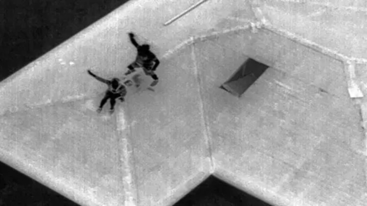
A suspect hides on a roof in complete darkness
Also, thermal sensors are incredibly helpful for public safety work when it comes to finding missing people at night. Whether it’s an older person with dementia who has become lost, or the victim of a car accident who has been thrown from their vehicle and can’t call for help, or someone lost in the mountains and in need of rescue, thermal drones have proved incredibly powerful for finding people in the dark and saving their lives.
The visual sensors on the X10 will also prove useful for both public safety applications and inspections. For instances where you need to zoom in from a distance, such as cell tower inspections or bridge inspections, the VT300-Z will present a powerful option.
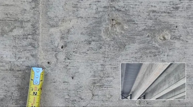
Detecting a 1mm crack in concrete under a bridge
The zoom could also prove useful for certain public safety applications, such as Drone as First Responder program, in which you need a camera that allows you to capture minute details like license plates from a distance.
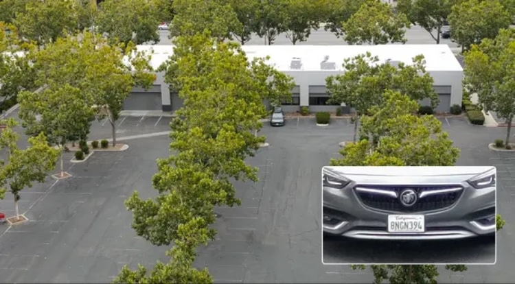
Reading a license plate from 800 feet away
Want to learn more about the Skydio X10? Read this blog post from Skydio.


