

Skydio Launches Skydio 3D Scan for Commercial 3D Mapping
BY Zacc Dukowitz
10 June 2021Skydio recently launched Skydio 3D Scan, a new 3D mapping software, with a big event at the US Space and Rocket Center in Huntsville, Alabama.
This video does a good job summing up the benefits of the new software, highlighting how it can be used in harmony with Skydio’s well-known autonomous flight to help commercial clients quickly create 3D models:

The new software is made for both professional inspectors and first responders, allowing them to quickly—and autonomously—create 3D models of critical infrastructure, accident scenes, or whatever they might need to model for the work at hand.
The software is available right now for the Skydio 2 at $2,999, and will be available soon for the Skydio X2 series.
For inspectors, Skydio 3D Scan will help them collect precise visual data so they can have detailed three-dimensional representations of the assets they’re inspecting.
These assets could be cell phone towers, semiconductor facilities, or dams, as shown in the video below:

For first responders, Skydio 3D Scan will help them to map the sites of major accidents in order to create a thorough record that can be investigated later to determine the cause of the event.
Such accidents could be the collapse of a highway, a fire, or a car accident, as highlighted in this 3D model:
What Makes Skydio 3D Scan Different?
One of the biggest differentiators of Skydio’s new software from other 3D modeling software is how it captures data.
Building a 3D model with drone photogrammetry requires a drone pilot to capture a certain amount of photographs to ensure a proper level of accuracy in the model. Doing this means the pilot has to fly specific flight paths to make sure they’re getting all the data they need.
Currently, a drone pilot can use basic automation to have the drone fly a 2D flight pattern, like the one shown below.
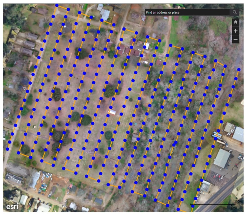
Photo credit: Skydio
Alternately, if the pilot wants to create a more realistic 3D model, they can fly manually around the structure they want to model and collect more data points to create a more complex, nuanced model.
But Skydio’s new software offers a third solution—3D automation.
Using Skydio’s AI-enable autonomy, the Skydio 2 can fly an automated flight path in three dimensions to capture all the images needed to produce a model of a complex structure.
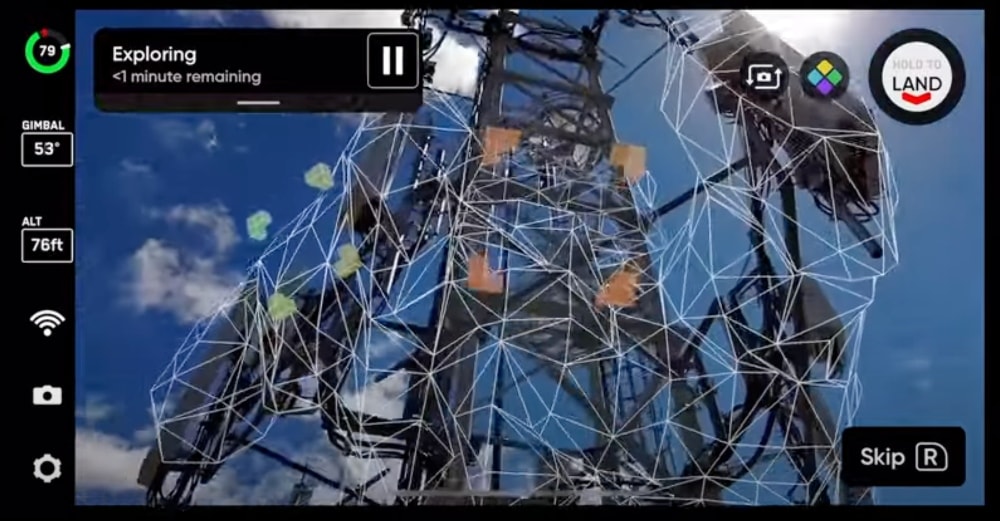
Photo credit: Skydio
These images can then be used to create an incredibly detailed digital twin—that is, a digital replica of the real thing being mapped.
This 3D autonomy for data capture means that users can ““fully automate the entire data capture process”—meaning, you don’t have to fly the drone to collect the data you need to make a highly detailed 3D scan.
Instead, you can tell the drone what you want to model, and then it will fly the path needed to get the appropriate data while building you a 3D map in real time.

Photo credit: Skydio
The value here is scalability for commercial drone programs, both for professional inspectors and first responders.
By making a plug-and-play solution, Skydio is allowing clients who need to create 3D models regularly a means to do so without the need to invest heavily in training a team of professional drone pilots.
That’s the pitch, at least—whether companies can rely solely on Skydio’s drones for all their inspection needs remains to be seen.
But the ability to create 3D models autonomously will certainly make it an attractive option for many commercial users, and may help make it one of the most sought after tools in an inspector’s toolkit.
Skydio 3D Scan Features
Here are some standout features for Skydio’s new software:
- Autonomous 3D scans—automatically create 3D scans of any structure, even complex ones.
- Automated flight paths—Skydio drone plans the shots, you choose the resolution.
- Highly precise—3D scans with precision of up to .65mm/pixel.
- Use 3D model while still on site—most 3D modeling software requires several hours to process, but Skydio’s 3D scans can be reviewed “instantly on site.”
- Compatibility—Skydio 3D Scan is compatible with several other types of 3D modeling software, including software from Pix4D, Bentley, DroneDeploy, and RealityCapture.
- Augmented reality—full coverage of the object being modeled can be verified in real time using augmented reality.
Here’s an image highlighting the augmented reality feature in Skydio 3D Scan, which can help ensure full coverage when creating 3D scans of an object:

Photo credit: Skydio
3D Models Made with Skydio 3D Scan
Want to see some more 3D models made with Skydio’s new software?
Here you go:
Mock helicopter crash
Corsair jet
Lunar lander
Excited about the launch of Skydio 3D Scan? Share your thoughts in this thread on the UAV Coach community forum.


