3D Drone Model Shows Red Bull’s Rampage Mountain Bike Course Like Never Before

BY Zacc Dukowitz
16 August 2022

The Red Bull Rampage is one of the biggest, gnarliest mountain bike events in the world.

It takes place in Southern Utah, and the course is created by the riders themselves, mapping out routes down sheer cliff faces that are nail biting to watch.

CRhub: 3D mountain map for Red Bull Rampage

Red Bull often uses drones to get up-close footage of its events—but even aerial shots can’t fully capture a rider’s run on one of the Rampage courses.

To help viewers get more immersed in the action, Red Bull brought in a company called Frontier Precision to use drone data to showcase the course in a highly detailed 3D model made using photogrammetry. The outputs from that work were a gamified 3D model and aerial flyovers of each rider’s specific line down the mountain with animations added in to show where they road.

We first started working on Rampage about five years ago . . . trying to add value to the event broadcast so people at home can get a better idea of the depth of these jumps, how gnarly this terrain is. We went from doing virtual reality to augmented reality and now we’re at broadcast AR, where we’re integrating the game engine with the live broadcast.

– Ryan Whitehead, Executive Producer at XR Media Group

Both the 3D model and the flyovers helped solve the problems presented by trying to cover an event that takes place in such a large, rugged environment, where it can be hard to fully capture a rider’s run so that the viewer can understand what they’re doing and what the terrain looks like from one moment to the next.

How Frontier Precision Created the 3D Model of the Rampage Course

Frontier Precision typically works using drones for surveying, mapping, and engineering, but it was happy to take up the unusual challenge of creating a 3D model of a course for mountain biking.

While broadcasting the event live, the host of Rampage stood next to a detailed 3D model of the entire course made using photogrammetry—but this wasn’t an ordinary 3D model.

course-3d-model

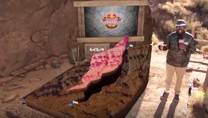
The 3D rendering that appeared on stage beside the host could be sectioned out to show viewers specific parts of the course, as well as all of the possible routes that the riders might take to get from start to finish.

course-red-bull-rampage
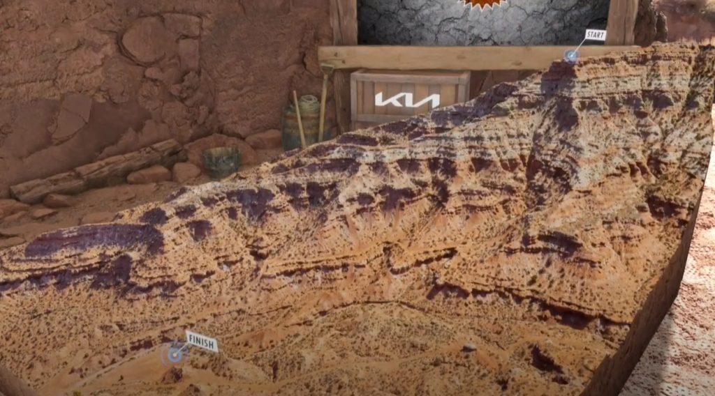
The 3D model of the Rampage course

possible-runs-rampage-course
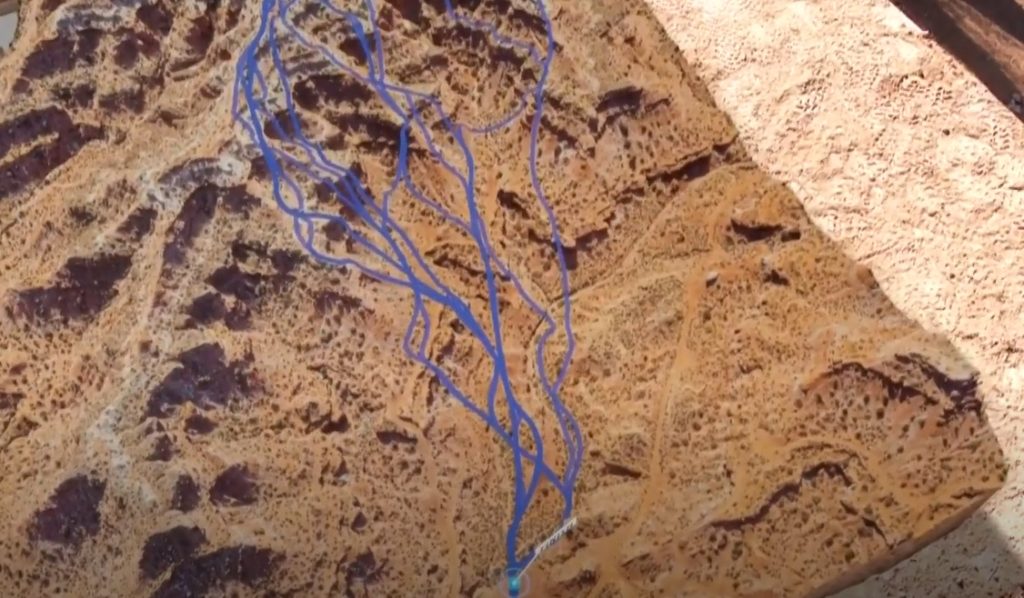
Possible routes down the course

How did Frontier Precision make the 3D model? Here’s an overview:

  • Data collection. The company’s pilots collected thousands of images over 12 hours of flight time.
  • Data processing. After data collection, the data was processed into a 3D mesh using high-end photogrammetry modeling software from Reality Capture.
  • Adding features. After creating the model, different features were added to it to “gamify” the experience for viewers, allowing the model to be sectioned out or to have lines running through it showing the different paths that could be taken through the course.

Although the data capture and processing were intense from a labor perspective, the final step was by far the one that made the 3D model a groundbreaking way to showcase the event.

The plan was to create a 3D point cloud and turn it into a 3D mesh, much like we use in mapping applications where we’re doing photogrammetry—tying all the images together to create a 3D model. But what was interesting here is they were not looking for necessarily accurate measurements, but rather, an entertaining way to display the environment.

– Wyatt Robbins, President of Air-Supply Aerial (a division of Frontier Precision)

By allowing viewers to see sections of specific areas of the course or follow specific paths down the mountain, Red Bull brought them into the reality of what it might be like to face huge drops down cliff faces at high speeds, highlighting just how difficult it is to navigate a course like this on a mountain bike.

Details and Challenges around Creating the 3D Model

To make the 3D model, the Frontier Precision team started by collecting thousands of images of the course with a Phase One 100MP geospatial camera equipped with an IXM 100/ 35mm lens attached to a DJI Matrice 300. Frontier Precision says this was one of the only M300s with this specific payload in North America at the time they did this.

redbull-rampage

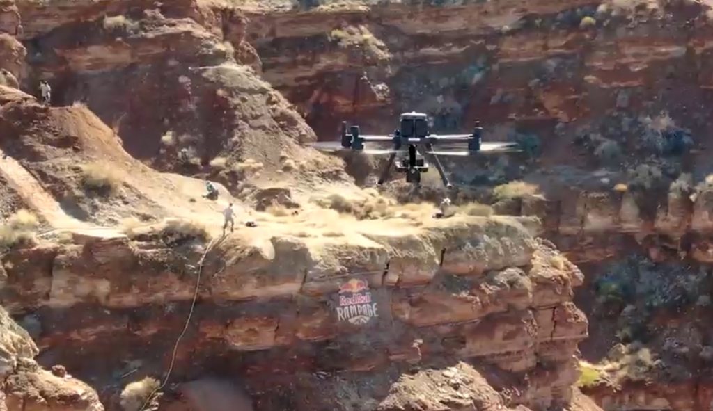
Image collection took place over about 12 hours of flying time in just a few days, with the drone flying back and forth up the 1,000-foot high cliff face at about 180 feet in the air to ensure they were getting enough coverage to create a detailed map.

The approach used for the data capture was basically the same as what you might use to create a 3D model for surveying or other commercial use cases, with the pilot flying a combination of grid missions capturing both Nadir and Oblique images using a flight plan that followed the terrain at a constant distance.

The environment was challenging, since they were flying at 5,000 feet of altitude with the density altitude around 7,000-feet, which meant the drone had to work harder than normal given the thinness of the air.

Another challenge was the time frame for flying. Since the landscape needed to be lit at a certain angle in order for it to be properly exposed, the Frontier Precision team could only fly early in the morning when the sun’s angle was just right before shadows began falling down the cliff face.

But all the hard work was worth it.

In the end, Frontier Precision created a highly detailed 3D map of the entire course that provided the kinds of animations Red Bull was looking for, pushing forward the way these kinds of events are rendered for viewers to make them come even more alive.

Want to see some mountain biking from the Rampage event? Check out this video of the winning run from last year:

Brandon Semenuk Makes Red Bull Rampage History Once Again | Winning Run 2021

Join a global community of

100,000+

drone enthusiasts.

Subscribe

Drone Pilot's Guide to DJI Mini 4 Pro

  • Navigate the DJI Fly app and flight modes with ease
  • Adjust camera and safety settings for better control
  • Understand intelligent flight features and how to use them
  • Avoid common beginner mistakes
  • Get the most out of your drone—without the guesswork

Drone Pilot's Guide to DJI Air 3S

  • Navigate the DJI Fly app and flight modes with ease
  • Adjust camera and safety settings for better control
  • Understand intelligent flight features and how to use them
  • Avoid common beginner mistakes
  • Get the most out of your drone—without the guesswork

Hands-On Flight Training

$295

400+ 5-Star Reviews

  • Team up with a knowledgeable, friendly instructor at a convenient outdoor spot — like a park or athletic field
  • Fly a top-rated drone provided for you, or bring your own to get personalized guidance
  • Spend most of your time in the air with hands-on practice — learning about composition, camera angles and cinematic motion
  • Explore the DJI Fly app and learn how to use camera settings like ISO, shutter speed and aperture
  • Unlock the power of Intelligent Flight Modes to fly smoother, smarter, and with less stress
  • Get access to our Aerial Photo & Video online course with additional exercises and pro-level editing workflows – using Snapseed, Photopea, Adobe Lightroom, DJI LightCut, and Premiere Pro

Aerial Photo & Video for Drone Pilots

$179

3,500+ 5-Star Reviews

  • How to dial in the right camera settings like ISO, shutter speed, and aperture
  • The best angles & altitudes for different types of shots (real estate, landscapes, cityscapes, and more)
  • The secret to cinematic drone motion that makes your footage feel like a Hollywood movie
  • How to enhance colors, remove distractions, and sharpen details – even in tricky lighting
  • Pro-level editing workflows – whether you’re using Lightroom, free tools, or mobile apps

The Recreational UAS Safety Test

Free

150+ 5-Star Reviews

  • Required for U.S. recreational flyers of drones
  • Launched June 2021 by the FAA
  • Takes about 30 minutes to complete
  • No prior drone knowledge needed
  • Test allows unlimited attempts to pass

Drone Mapping Essentials Workshop

$799

3,500+ 5-Star Reviews

  • Expert instruction from expert drone pilots with over 100 hours of flying experience
  • Hands-on training of live data capture and how to process deliverables for your clients
  • Peer-to-peer networking with other professional drone pilots in the mapping industry
  • Free access to the online course, Drone Mapping Essentials

Flight Skills for Drone Pilots

$99

75+ 5-Star Reviews

  • 16 engaging video lectures with key takeaways
  • Action items with concrete steps so you put into practice what you learn
  • Pre-flight checklists to help you plan your flights
  • Resource links to websites, products and software for further learning and discovery

Drone Business & Mapping Bundle

$617 $397

3,500+ 5-Star Reviews

  • Drone Pilot Ground School
    1. 1:1 support with a Part 107 exam success coach
    2. Study 100% online at your own pace
    3. Unlimited practice exams with 400+ real FAA test questions
  • Drone Mapping Essentials
    1. 100+ instructional videos focused on real-world application with high-quality videos
    2. Downloadable resources like data capture checklists to utilize in your missions
    3. Monthly live instruction with course instructor, Dylan Gorman, to go deeper on topics where you need more clarification
  • The Drone Business Blueprint
    1. Expert instruction from industry veteran, Eno Umoh, who brings real-world experience in building successful drone businesses.
    2. 14 Comprehensive modules covering everything from business setup to marketing strategies
    3. 30 Downloadable resources to apply your learning immediately

Hands-On Flight Training

$295

400+ 5-Star Reviews

  • 45-60 minutes of hands-on flying time to master orientation and flight maneuvers tailored to your skill level
  • Learn how to handle obstacles such as lost GPS, low battery charge or emergencies
  • Practice flying under various intelligent flight modes
  • Ask questions about regulations, software, flight operations management, and more

The Drone Business Blueprint

$119

3,500+ 5-Star Reviews

  • Expert instruction from industry veteran, Eno Umoh, who brings real-world experience in building successful drone businesses.
  • 14 Comprehensive modules covering everything from business setup to marketing strategies
  • 30 Downloadable resources to apply your learning immediately
  • AI tools and techniques to boost productivity and streamline your operations

Commercial Drone Business Bundle

$418 $334

4,000+ 5-Star Reviews

  • Drone Pilot Ground School
    1. 1:1 support with a Part 107 exam success coach
    2. Study 100% online at your own pace
    3. Unlimited practice exams with 400+ real FAA test questions
  • The Drone Business Blueprint
    1. Expert instruction from industry veteran, Eno Umoh, who brings real-world experience in building successful drone businesses.
    2. 14 Comprehensive modules covering everything from business setup to marketing strategies
    3. 30 Downloadable resources to apply your learning immediately

Drone Mapping Essentials

$199

3,500+ 5-Star Reviews

  • 100+ instructional videos focused on real-world application with high-quality videos
  • Downloadable resources like data capture checklists to utilize in your missions
  • Quizzes to test your knowledge so you can succeed in the field
  • Monthly live instruction with course instructor, Dylan Gorman, to go deeper on topics where you need more clarification

Drone Pilot Pro Bundle

$713 $499

3,500+ 5-Star Reviews

  • Drone Pilot Ground School
    1. 1:1 support with a Part 107 exam success coach
    2. Study 100% online at your own pace
    3. Unlimited practice exams with 400+ real FAA test questions
  • Drone Pilot Skill Builder
    1. 16 engaging video lectures with key takeaways
    2. Action items with concrete steps so you put into practice what you learn
  • Hands-On Flight Training
    1. 45-60 minutes of hands-on flying time to master orientation and flight maneuvers tailored to your skill level

Drone Pilot Ground School

$299

4,000+ 5-Star Reviews

  • 1:1 support with a Part 107 exam success coach
  • Study 100% online at your own pace
  • Unlimited practice exams with 400+ real FAA test questions
  • Personalized study plans, virtual flashcards, and 12-page cram sheet
  • Weekly webinars on acing the Part 107 exam and monthly webinars to elevate your journey post-certification