

Landslide Prevention by Drone—How Swiss Federal Railways Uses Hill Scan to Map Mountainous Terrain
BY Zacc Dukowitz
11 March 2021Swiss Federal Railways (SBB), the largest public transportation company in Switzerland, has been using special drone software to help improve its rockslide inspections.
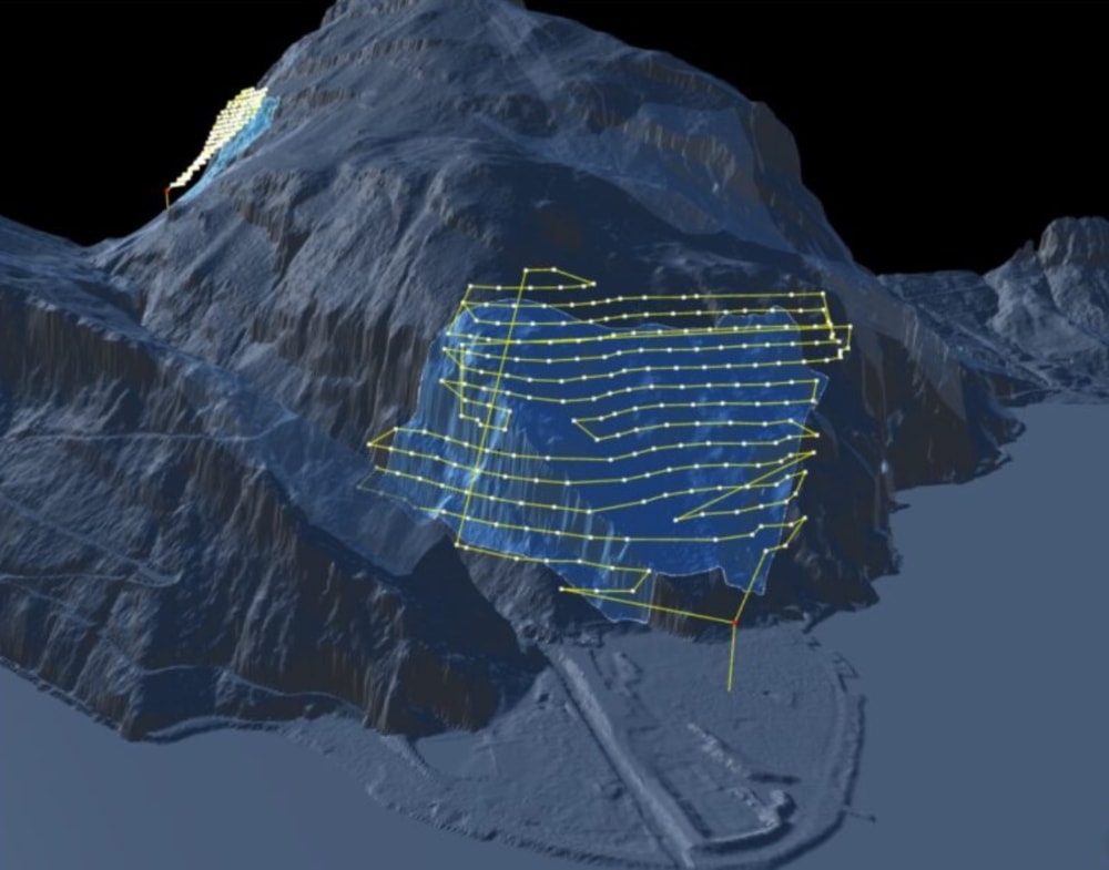
Image credit: Drone Harmony
Switzerland is an incredibly mountainous country. The Swiss Alps cover about 58% of the country, and it contains 49 mountains that are 2.5 miles high or higher (called 4,000-ers, because they reach up to 4,000 meters or more).
Given this terrain, the threat of rockslides is always present.
This means that SBB inspectors must practice constant vigilance, monitoring the company’s extensive rail infrastructure for signs of imminent landslides and rockslides, and trying to prevent or mitigate them wherever possible.
Drone Harmony’s Hill Scan, an automated flight mission planning software, is the latest resource SBB inspectors have adopted to help with these efforts.
Using maps made with data captured by Hill Scan, along with traditional rockslide inspection methods like terrestrial laser scanning—a ground-based version of LiDAR—SBB inspectors are getting a more robust dataset to work from in determining the threat level of rockslides in a given area.
How SBB Uses Hill Scan
SBB is on the cutting edge of technology, and has been using drones as an aerial data collection tool for several years. In 2017, the company created its Center of Competence for Drones, which currently contains a fleet of 80 drones operated by over 100 specially trained pilots.
But collecting aerial data of steep, mountainous terrain that is of a high enough quality to be used for making 3D maps isn’t easy.
That’s where Hill Scan comes in.
Inspectors at SBB are using Hill Scan to narrow the list of areas where rockslides are especially likely, and then focus their energy only on those places using in-person data collection methods like climbing and rappelling.
This approach helps SBB to narrow the scope of its in-person operations, thus improving safety while also addressing the biggest challenge its inspection team faces: dealing with the sheer volume of land there is to inspect.
How Hill Scan Helps Inspectors Map Tricky Terrain
Hill Scan helps inspectors identify the areas with the highest risks for rockslides by capturing aerial data that can be used to create displacement maps—maps showing how displaced rocks and debris are in a given area.
The displacement map shown below is of a cliff in Brienz, Switzerland and was generated by SBB using drone imagery captured with Hill Scan. (The yellow and orange areas in the map correspond to parts of the cliff with the largest registered displacement.)
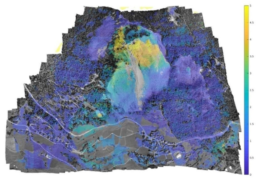
Image credit: Drone Harmony
Here’s how a displacement map is created:
- Drone pilot collects aerial images using Hill Scan, which helps to capture visual data of steep, non-uniform terrain
- Inspectors process the Hill Scan data using photogrammetry software to create orthophotos of the area
- Inspectors overlay the orthophotos to generate the displacement map
Note that the image set is usually captured at various resolutions so that inspectors can visually inspect an area of interest at different levels of detail.
Check out this video featuring a 3D model created using data collected by Hill Scan:

Hill Scan Helps Capture Data, Not Process It
One thing might jump out at you from the list above detailing how Hill Scan is used for creating displacement maps: the software helps pilots capture aerial data, not process it.
When we think of drone software, we usually think of software that takes aerial images and processes them into 3D maps, orthomosaic maps, or some other output.
But Hill Scan is used for the data capture itself.
Why? Because capturing aerial images of steep, uneven, or otherwise complex terrain for the creation of a 3D map is much more difficult than it is for flat, uniform terrain.
Gathering the required drone data [to map steep cliffs] is challenging for several reasons. In the past, there was no software solution out there that could automate flight planning . . . [Hill Scan] will make it possible for us to train dozens of pilots with different skill levels to do this complicated job.
– Nicolas Ackermann, Development Engineer Drones at Drone Competence Centre in SBB
While traditional mapping based on aerial data relies on grid missions, mapping steep terrain benefits from having the camera always face the surface and from avoiding uniformity in the overlapping of image collection.
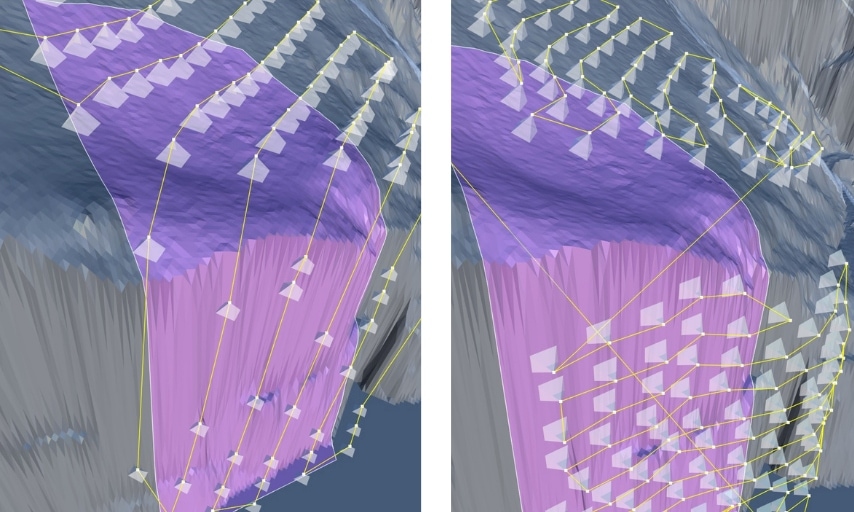
Image credit: Drone Harmony
Here are the primary use cases Drone Harmony recommends for Hill Scan:
- When the terrain to be inspected is very steep (even vertical), e.g. when it represents cliffs, rock walls, steep hills, or even structures, such as dams.
- When the terrain profile is very non-uniform, e.g. hills, mountain peaks, canyons, and valleys, or combinations of flat and steep sections of a landscape.
- When it is important to direct the camera perpendicularly at the terrain surface.
Using Hill Scan, SBB can lower the amount of risk faced by inspectors conducting in-person data collection missions, since it helps reduce the overall number of such missions. The software can also help SBB improve its overall assessment of risk from rockslides and landslides, which will not only serve to further protect its rail lines but will also improve safety along them.
Can you think of other complex mapping scenarios that might benefit from the use of Hill Scan? Share your thoughts in this post on the UAV Coach community forum.


