Skyfire Helps City of Fremont Launch First Joint Police/Fire Drone Responder Program

BY Zacc Dukowitz
28 February 2024

The City of Fremont’s police and fire departments have launched the first ever joint drone as first responder (DFR) program in the U.S., and most likely the world.

From November 2022 to January 2023 the Fremont Police and Fire Departments ran a pilot program, allowing them to do tests, collect data, and communicate with the public about what they were planning to do, and why.

In the pilot, drones were deployed from strategic locations to respond to 911 calls related to both law enforcement and fire emergencies, such as crimes in progress, fires, traffic accidents, and reports of dangerous subjects. The initiative proved successful, helping reduce response times for emergency calls and enhancing the safety of first responders and the public.

fremont-police-fire-dfr-program
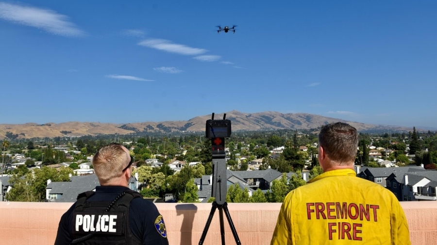
Credit: The City of Fremont

Here’s how the Fremont DFR program works:

  • Deployment. When a 911 call comes in, a remote pilot dispatches a drone autonomously to the location of the call using software from Dronesense.
  • At the scene. Once there, the remote pilot controls the aircraft and its camera or other sensors, providing a live video feed with valuable situational awareness of the incident to key stakeholders, including officers or firefighters who are en route.
  • After the response. When the appropriate response is implemented and the call is cleared, the remote pilot clicks a button and the drone autonomously returns to the landing site, where it can be prepared for the next call.

Skyfire’s Key Role in DFR Programs

From a regulatory perspective, DFR programs can be tricky to launch because they require flying BVLOS.

That hurdle is the reason there are still so few DFR programs. According to the National League of Cities, there were only 15 DFR programs in the U.S. as of November last year.

This is where a company like Skyfire comes in. Skyfire offers UAV consulting services for public safety agencies, helping them navigate drone regulations and secure complicated permissions.

Skyfire has an impressive history with DFR programs.

chula-vista-pd-dfr-program
Credit: Chula Vista Police Departments

Back in 2019, it helped the Chula Vista Police Department (CVPD) launch the very first DFR program. In the process, Skyfire helped invent the idea of sending a drone to the scene of a 911 call as well as the “DFR” terminology that’s now commonly used to describe these operations.

To get the CVPD program live, Skyfire had to help the department obtain the first ever emergency response Certificate of Authorization (COA) with a Beyond Visual Line of Sight (BVLOS) provision for public safety. Since then, Skyfire has been part of launching at least a dozen DFR programs, making it the primary DFR consulting company in the country.

We’re proud to work with Skyfire to launch this groundbreaking DFR program. This program has the potential to save lives and make our community safer, and Skyfire’s expertise has been invaluable in getting us to this point.

– Jeff Kleven, Battalion Chief of the Fremont Fire Department

The Fremont program deploys drones from a few strategic locations in the city, including the roof of an apartment building called Parkway Towers.

Soon, a new partnership with the Washington Hospital Healthcare System will allow first responders to deploy drones from the roof of a local hospital as well.

What Is a Drone Responder Program?

In a drone responder program (or DFR program) drones fly immediately to the scene of an emergency, providing a live aerial feed to first responders en route.

How to reduce 911 response times by 50% - DFR Explained

These programs give police officers get real-time situational awareness, helping them:

  • Track fleeing suspects
  • Make better decisions
  • Avoid being ambushed
  • De-escalate situations—and sometimes even avoid going to a scene altogether

For the most part, these programs have been used only by law enforcement. But other public safety agencies can also benefit from having on-demand aerial intel from unfolding scenes, with fire departments being at the top of the list.

But it’s important to note that DFR programs aren’t the only way that fire and police departments use drones.

Here are just some of the public safety use cases for drones listed on Fremont’s website:

  • Public safety and life preservation missions, including barricaded suspects, hostage situations, active shooters, apprehension of armed and dangerous fleeing suspects, and high-risk search warrants
  • Mass casualty events
  • Lost or missing persons
  • Rescue events
  • Disaster response and recovery
  • Suspected explosive devices
  • Fire suppression or investigation
  • Hazardous material releases
  • Post-incident crime scene preservation and documentation
  • Pursuant to a search warrant
  • Special Events

Want to see more? Check out our guide to drones in public safety, which includes 54 different use cases.

Join a global community of

100,000+

drone enthusiasts.

Subscribe

Drone Pilot's Guide to DJI Mini 4 Pro

  • Navigate the DJI Fly app and flight modes with ease
  • Adjust camera and safety settings for better control
  • Understand intelligent flight features and how to use them
  • Avoid common beginner mistakes
  • Get the most out of your drone—without the guesswork

Drone Pilot's Guide to DJI Air 3S

  • Navigate the DJI Fly app and flight modes with ease
  • Adjust camera and safety settings for better control
  • Understand intelligent flight features and how to use them
  • Avoid common beginner mistakes
  • Get the most out of your drone—without the guesswork

Hands-On Flight Training

$295

400+ 5-Star Reviews

  • Team up with a knowledgeable, friendly instructor at a convenient outdoor spot — like a park or athletic field
  • Fly a top-rated drone provided for you, or bring your own to get personalized guidance
  • Spend most of your time in the air with hands-on practice — learning about composition, camera angles and cinematic motion
  • Explore the DJI Fly app and learn how to use camera settings like ISO, shutter speed and aperture
  • Unlock the power of Intelligent Flight Modes to fly smoother, smarter, and with less stress
  • Get access to our Aerial Photo & Video online course with additional exercises and pro-level editing workflows – using Snapseed, Photopea, Adobe Lightroom, DJI LightCut, and Premiere Pro

Aerial Photo & Video for Drone Pilots

$179

3,500+ 5-Star Reviews

  • How to dial in the right camera settings like ISO, shutter speed, and aperture
  • The best angles & altitudes for different types of shots (real estate, landscapes, cityscapes, and more)
  • The secret to cinematic drone motion that makes your footage feel like a Hollywood movie
  • How to enhance colors, remove distractions, and sharpen details – even in tricky lighting
  • Pro-level editing workflows – whether you’re using Lightroom, free tools, or mobile apps

The Recreational UAS Safety Test

Free

150+ 5-Star Reviews

  • Required for U.S. recreational flyers of drones
  • Launched June 2021 by the FAA
  • Takes about 30 minutes to complete
  • No prior drone knowledge needed
  • Test allows unlimited attempts to pass

Drone Mapping Essentials Workshop

$799

3,500+ 5-Star Reviews

  • Expert instruction from expert drone pilots with over 100 hours of flying experience
  • Hands-on training of live data capture and how to process deliverables for your clients
  • Peer-to-peer networking with other professional drone pilots in the mapping industry
  • Free access to the online course, Drone Mapping Essentials

Flight Skills for Drone Pilots

$99

75+ 5-Star Reviews

  • 16 engaging video lectures with key takeaways
  • Action items with concrete steps so you put into practice what you learn
  • Pre-flight checklists to help you plan your flights
  • Resource links to websites, products and software for further learning and discovery

Drone Business & Mapping Bundle

$617 $397

3,500+ 5-Star Reviews

  • Drone Pilot Ground School
    1. 1:1 support with a Part 107 exam success coach
    2. Study 100% online at your own pace
    3. Unlimited practice exams with 400+ real FAA test questions
  • Drone Mapping Essentials
    1. 100+ instructional videos focused on real-world application with high-quality videos
    2. Downloadable resources like data capture checklists to utilize in your missions
    3. Monthly live instruction with course instructor, Dylan Gorman, to go deeper on topics where you need more clarification
  • The Drone Business Blueprint
    1. Expert instruction from industry veteran, Eno Umoh, who brings real-world experience in building successful drone businesses.
    2. 14 Comprehensive modules covering everything from business setup to marketing strategies
    3. 30 Downloadable resources to apply your learning immediately

Hands-On Flight Training

$295

400+ 5-Star Reviews

  • 45-60 minutes of hands-on flying time to master orientation and flight maneuvers tailored to your skill level
  • Learn how to handle obstacles such as lost GPS, low battery charge or emergencies
  • Practice flying under various intelligent flight modes
  • Ask questions about regulations, software, flight operations management, and more

The Drone Business Blueprint

$119

3,500+ 5-Star Reviews

  • Expert instruction from industry veteran, Eno Umoh, who brings real-world experience in building successful drone businesses.
  • 14 Comprehensive modules covering everything from business setup to marketing strategies
  • 30 Downloadable resources to apply your learning immediately
  • AI tools and techniques to boost productivity and streamline your operations

Commercial Drone Business Bundle

$418 $334

4,000+ 5-Star Reviews

  • Drone Pilot Ground School
    1. 1:1 support with a Part 107 exam success coach
    2. Study 100% online at your own pace
    3. Unlimited practice exams with 400+ real FAA test questions
  • The Drone Business Blueprint
    1. Expert instruction from industry veteran, Eno Umoh, who brings real-world experience in building successful drone businesses.
    2. 14 Comprehensive modules covering everything from business setup to marketing strategies
    3. 30 Downloadable resources to apply your learning immediately

Drone Mapping Essentials

$199

3,500+ 5-Star Reviews

  • 100+ instructional videos focused on real-world application with high-quality videos
  • Downloadable resources like data capture checklists to utilize in your missions
  • Quizzes to test your knowledge so you can succeed in the field
  • Monthly live instruction with course instructor, Dylan Gorman, to go deeper on topics where you need more clarification

Drone Pilot Pro Bundle

$713 $499

3,500+ 5-Star Reviews

  • Drone Pilot Ground School
    1. 1:1 support with a Part 107 exam success coach
    2. Study 100% online at your own pace
    3. Unlimited practice exams with 400+ real FAA test questions
  • Drone Pilot Skill Builder
    1. 16 engaging video lectures with key takeaways
    2. Action items with concrete steps so you put into practice what you learn
  • Hands-On Flight Training
    1. 45-60 minutes of hands-on flying time to master orientation and flight maneuvers tailored to your skill level

Drone Pilot Ground School

$299

4,000+ 5-Star Reviews

  • 1:1 support with a Part 107 exam success coach
  • Study 100% online at your own pace
  • Unlimited practice exams with 400+ real FAA test questions
  • Personalized study plans, virtual flashcards, and 12-page cram sheet
  • Weekly webinars on acing the Part 107 exam and monthly webinars to elevate your journey post-certification