Flyhound Has Developed a Better Way to Use Drones to Find Missing People

BY Zacc Dukowitz
1 February 2023

We all know drones can be used to find missing people.

But what if the process could be sped up?

A new startup called Flyhound aims to do just that. By pairing its technology with a drone, the company claims that missing people can be found in just 30 minutes or less.

flyhound-search-rescue
Credit: Flyhound

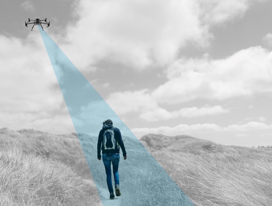
The company makes a drone-mounted module that uses radio signals to find missing people. The module can currently be used with any drones in the DJI Phantom or Matrice series, Yuneec’s Typhoon, and the Phy Sci Instant Eye.

Flyhound recently graduated from the NEC X startup incubator program, an experience that helped it test and hone its technology from concept to viable product.

[Related read: What Is a Remote ID Module? A Complete Guide to FAA-Compliant Remote ID Broadcast Modules]

While in the accelerator, Flyhound’s module was used in several proof of concept missions in partnership with public safety agencies to test its potential benefits for first responders.

Public safety and disaster response are resource intensive. First responders are often in need of additional manpower—technology that saves time, money, and lives will always be in demand.

– Shige Ihara, President and CEO of NEC X

As Flyhound develops its technology, compatibility with other drone models will be added, including drones from Skydio, Parrot, and BRINC.

How Does FlyHound Work?

The Flyhound module works by triangulating cell signals from the phones of missing people, helping to locate them.

The cutting-edge localization algorithms used in the module don’t require an active cellular network, so it can be used in remote areas in which cellular network infrastructure isn’t available, or after a disaster, when cell service may be temporarily down.

Whether it’s a lost hiker, a victim of a natural disaster, or a person suffering from dementia lost in an urban environment, a drone equipped with a Flyhound module can figure out their location quickly—so long as they have their cell phone on them.

Cellphones are something people always carry with them, so if we need to find someone in an emergency, this is a tool that can get us to them faster, and ultimately help save lives.

– Corey Hoefling, Firefighter at Carlstadt Fire Department in Carlstadt, New Jersey

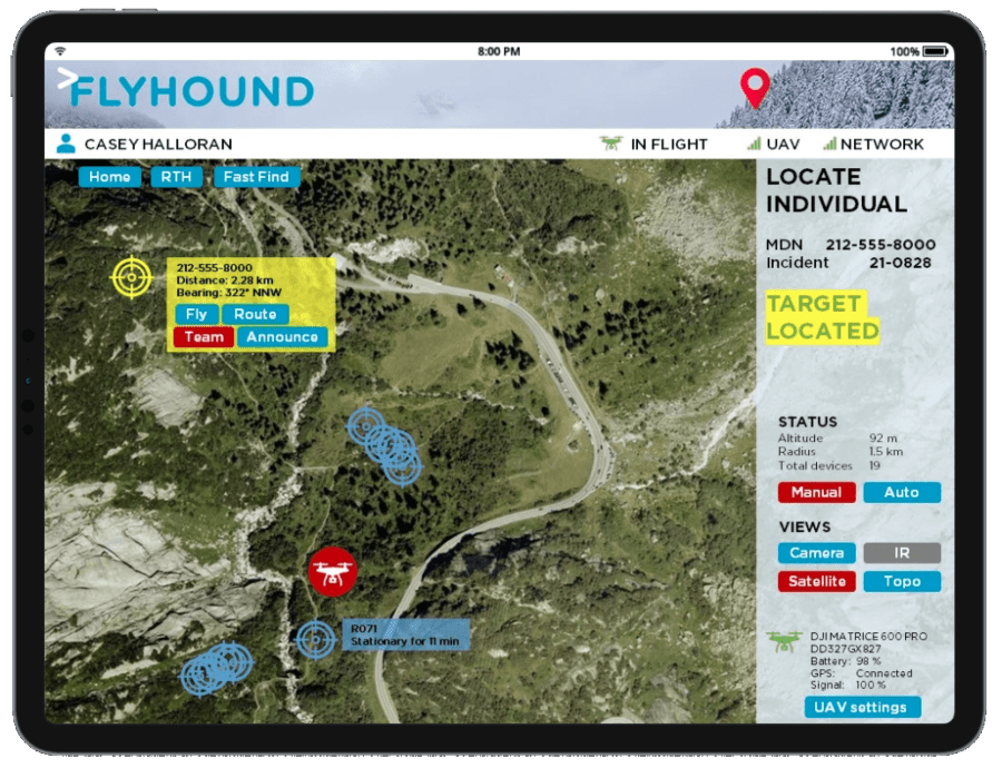
The information Flyhound collects is displayed on a digital map of the search area, allowing first responders to get a thorough visualization of missing people and those involved in the rescue operation as well.

flyhound-tablet
Credit: Flyhound

This visualization can help search and rescue teams overcome the temperature limitations of thermal imaging cameras, providing useful data on the precise location of missing people to guide tactical efforts in real time.

The technology can also be used to track the location of resources being used in the operation, a feature that can help agencies work together effectively in high pressure situations.

The Flyhound module isn’t yet available for sale, but you can be added to the waitlist on the company’s website.

The Advancement of Drones in Search and Rescue

Only a few years back, whenever a drone was used to find a missing person the event was noteworthy enough to make the news.

But today these kinds of rescues happen all the time (though some of them still make the news, of course).

The point is, in just a few short years we’ve seen a major transformation in the use of drones for search and rescue operations, with more and more public safety agencies acquiring drones to find missing people, and more and more people being found by drone.

And in many cases, the drone was the decisive factor in finding the person or people in time to save their lives. Thanks to aerial thermography and the speed with which drones can find people, they present one of the best tools for this kind of operation.

To get a sense for just how big of an impact drones are having in search and rescue check out DJI’s map of drone rescues, which shows all the incidents in which a drone was used to rescue a person from peril.

dji-drone-rescues
Credit: DJI

We should note that the numbers on the map above only reflect the number of cases in which a drone was instrumental in the rescue effort. If a drone is part of a rescue effort but isn’t the cause of the missing person being founded or aided, then it doesn’t count.

Here are DJI’s total accumulated numbers so far for drone rescues around the world:

  • 940 total number of people saved
  • 551 number of rescue incidents
  • 39 countries in which drone rescues took place

Helping advance the drone rescue cause, DJI recently put out a SAR (Search And Rescue) Altitude Guide.

The guide helps first responders quickly determine the best altitude for their specific mission and technology to have the greatest chance of finding a missing person.

Watch this video to learn more about how the guide works:

Drone SAR Altitude Guide - Explainer Video

Want to learn more about how drones are used in rescue operations? Here are a few other resources:

Join a global community of

100,000+

drone enthusiasts.

Subscribe

Drone Pilot's Guide to DJI Mini 4 Pro

  • Navigate the DJI Fly app and flight modes with ease
  • Adjust camera and safety settings for better control
  • Understand intelligent flight features and how to use them
  • Avoid common beginner mistakes
  • Get the most out of your drone—without the guesswork

Drone Pilot's Guide to DJI Air 3S

  • Navigate the DJI Fly app and flight modes with ease
  • Adjust camera and safety settings for better control
  • Understand intelligent flight features and how to use them
  • Avoid common beginner mistakes
  • Get the most out of your drone—without the guesswork

Hands-On Flight Training

$295

400+ 5-Star Reviews

  • Team up with a knowledgeable, friendly instructor at a convenient outdoor spot — like a park or athletic field
  • Fly a top-rated drone provided for you, or bring your own to get personalized guidance
  • Spend most of your time in the air with hands-on practice — learning about composition, camera angles and cinematic motion
  • Explore the DJI Fly app and learn how to use camera settings like ISO, shutter speed and aperture
  • Unlock the power of Intelligent Flight Modes to fly smoother, smarter, and with less stress
  • Get access to our Aerial Photo & Video online course with additional exercises and pro-level editing workflows – using Snapseed, Photopea, Adobe Lightroom, DJI LightCut, and Premiere Pro

Aerial Photo & Video for Drone Pilots

$179

3,500+ 5-Star Reviews

  • How to dial in the right camera settings like ISO, shutter speed, and aperture
  • The best angles & altitudes for different types of shots (real estate, landscapes, cityscapes, and more)
  • The secret to cinematic drone motion that makes your footage feel like a Hollywood movie
  • How to enhance colors, remove distractions, and sharpen details – even in tricky lighting
  • Pro-level editing workflows – whether you’re using Lightroom, free tools, or mobile apps

The Recreational UAS Safety Test

Free

150+ 5-Star Reviews

  • Required for U.S. recreational flyers of drones
  • Launched June 2021 by the FAA
  • Takes about 30 minutes to complete
  • No prior drone knowledge needed
  • Test allows unlimited attempts to pass

Drone Mapping Essentials Workshop

$799

3,500+ 5-Star Reviews

  • Expert instruction from expert drone pilots with over 100 hours of flying experience
  • Hands-on training of live data capture and how to process deliverables for your clients
  • Peer-to-peer networking with other professional drone pilots in the mapping industry
  • Free access to the online course, Drone Mapping Essentials

Flight Skills for Drone Pilots

$99

75+ 5-Star Reviews

  • 16 engaging video lectures with key takeaways
  • Action items with concrete steps so you put into practice what you learn
  • Pre-flight checklists to help you plan your flights
  • Resource links to websites, products and software for further learning and discovery

Drone Business & Mapping Bundle

$617 $397

3,500+ 5-Star Reviews

  • Drone Pilot Ground School
    1. 1:1 support with a Part 107 exam success coach
    2. Study 100% online at your own pace
    3. Unlimited practice exams with 400+ real FAA test questions
  • Drone Mapping Essentials
    1. 100+ instructional videos focused on real-world application with high-quality videos
    2. Downloadable resources like data capture checklists to utilize in your missions
    3. Monthly live instruction with course instructor, Dylan Gorman, to go deeper on topics where you need more clarification
  • The Drone Business Blueprint
    1. Expert instruction from industry veteran, Eno Umoh, who brings real-world experience in building successful drone businesses.
    2. 14 Comprehensive modules covering everything from business setup to marketing strategies
    3. 30 Downloadable resources to apply your learning immediately

Hands-On Flight Training

$295

400+ 5-Star Reviews

  • 45-60 minutes of hands-on flying time to master orientation and flight maneuvers tailored to your skill level
  • Learn how to handle obstacles such as lost GPS, low battery charge or emergencies
  • Practice flying under various intelligent flight modes
  • Ask questions about regulations, software, flight operations management, and more

The Drone Business Blueprint

$119

3,500+ 5-Star Reviews

  • Expert instruction from industry veteran, Eno Umoh, who brings real-world experience in building successful drone businesses.
  • 14 Comprehensive modules covering everything from business setup to marketing strategies
  • 30 Downloadable resources to apply your learning immediately
  • AI tools and techniques to boost productivity and streamline your operations

Commercial Drone Business Bundle

$418 $334

4,000+ 5-Star Reviews

  • Drone Pilot Ground School
    1. 1:1 support with a Part 107 exam success coach
    2. Study 100% online at your own pace
    3. Unlimited practice exams with 400+ real FAA test questions
  • The Drone Business Blueprint
    1. Expert instruction from industry veteran, Eno Umoh, who brings real-world experience in building successful drone businesses.
    2. 14 Comprehensive modules covering everything from business setup to marketing strategies
    3. 30 Downloadable resources to apply your learning immediately

Drone Mapping Essentials

$199

3,500+ 5-Star Reviews

  • 100+ instructional videos focused on real-world application with high-quality videos
  • Downloadable resources like data capture checklists to utilize in your missions
  • Quizzes to test your knowledge so you can succeed in the field
  • Monthly live instruction with course instructor, Dylan Gorman, to go deeper on topics where you need more clarification

Drone Pilot Pro Bundle

$713 $499

3,500+ 5-Star Reviews

  • Drone Pilot Ground School
    1. 1:1 support with a Part 107 exam success coach
    2. Study 100% online at your own pace
    3. Unlimited practice exams with 400+ real FAA test questions
  • Drone Pilot Skill Builder
    1. 16 engaging video lectures with key takeaways
    2. Action items with concrete steps so you put into practice what you learn
  • Hands-On Flight Training
    1. 45-60 minutes of hands-on flying time to master orientation and flight maneuvers tailored to your skill level

Drone Pilot Ground School

$299

4,000+ 5-Star Reviews

  • 1:1 support with a Part 107 exam success coach
  • Study 100% online at your own pace
  • Unlimited practice exams with 400+ real FAA test questions
  • Personalized study plans, virtual flashcards, and 12-page cram sheet
  • Weekly webinars on acing the Part 107 exam and monthly webinars to elevate your journey post-certification