

Researchers Use Drones to Study Active Volcano in Guatemala
BY Zacc Dukowitz
27 May 2020In another drones for good story, researchers from the Centre for Geosciences (GFZ) in Germany are using drones equipped with visual and thermal cameras to study the active Santa Maria volcano, located in Guatemala.
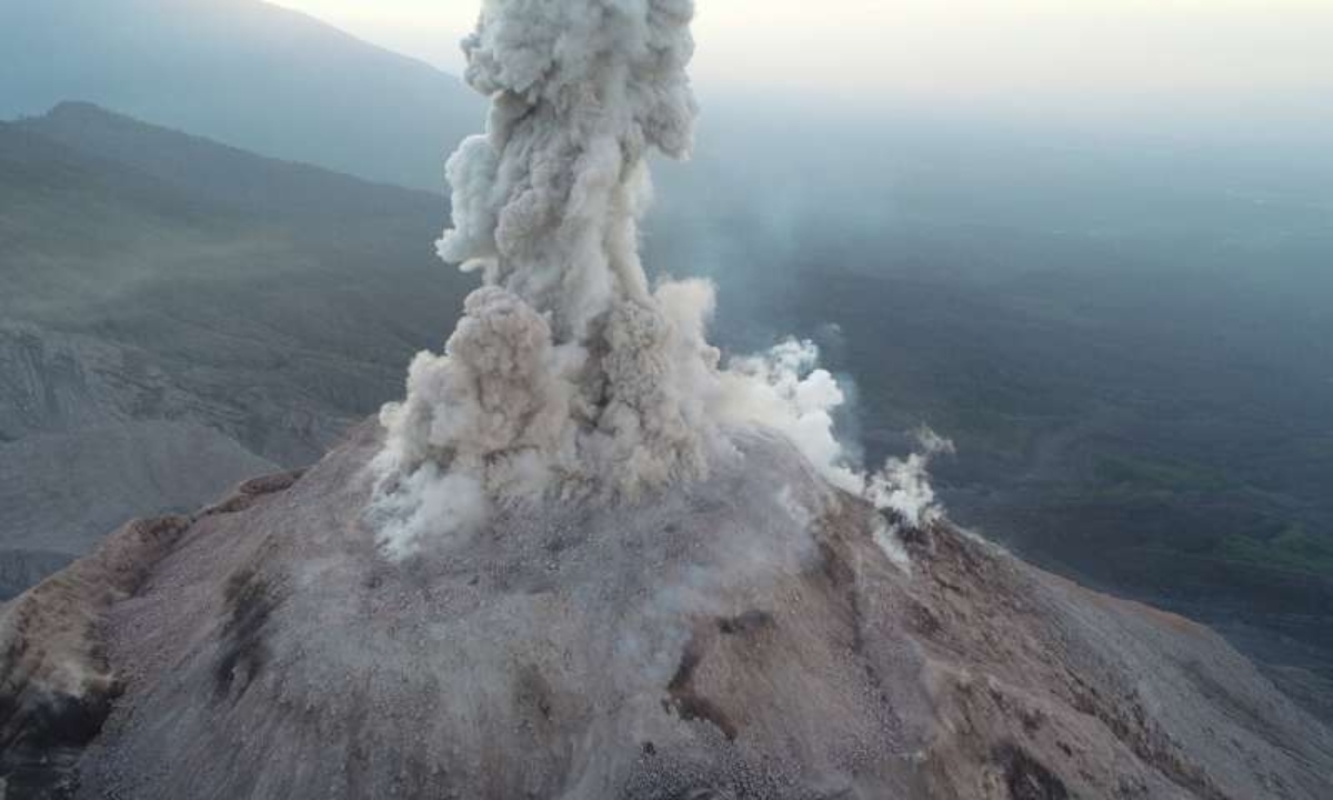
Photo Credit: Zorn et al. 2020, Nature – Scientific Reports: DOI 1
Capturing images of active volcanoes has been a challenge for volcanologists (scientists who study volcanoes) for a long time. Volcanoes present incredibly dangerous, volatile areas where the ground could collapse beneath you or flaming projectiles could suddenly fly at you at any moment.
They’re also huge, which means that most shots you can get from the ground won’t contain enough visual data to be useful, and not nearly enough to create a 3D map for further research.
Aerial imaging is the ideal solution, but helicopters are cost-prohibitive for most any research budget. Drones, on the other hand, provide a cost-effective solution for researchers, and one that continues to improve as drone technology evolves.
We have shown that the use of drones can help to completely re-measure even the most dangerous and active volcanoes on Earth from a safe distance.
– Edgar Zorn, First Author on GFZ’s study
How the GFZ Team Uses Drones in Their Volcano Research
In a series of survey flights led by PhD candidate Edgar Zorn, GFZ researchers captured both visual and thermal data that has provided key insights into the movement of lava within the Santa Maria volcano.
The surveys were made with a DJI Phantom 4 Pro. Optical images of the volcano were captured with the Phantom’s sRGB camera, and thermal images were captured with a FLIR TAU 2.
The data researchers gathered by drone over four flights at the Santa Maria volcano allowed them to create 3D models of the volcano, including a 3D topography and temperature model of the volcano with a resolution of only a few centimeters.
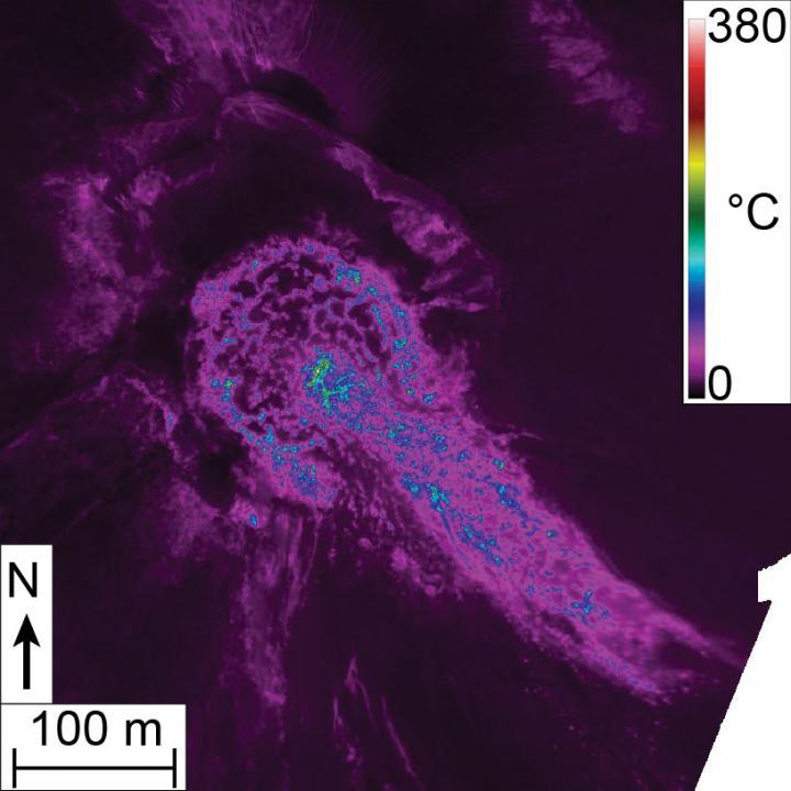
Photo Credit: Zorn et al. 2020, Nature – Scientific Reports: DOI 1
Using these models and the other data gathered, researchers have found that the volcano’s lava dome—a viscous “plug” of lava—shows movements on two distinct time scales. One time scale is the slow expansion and growth of the dome, and the second is the fast extrusion, or out-flowing, of viscous lava from the dome.
These findings have helped researchers demonstrate that motion patterns at lava domes control a volcano’s structural and thermal architecture, which makes timescale considerations crucial to understanding and improving the assessment of volcanic hazards—and to understanding how likely an eruption might be.
The data the GFZ team obtained by drone has also helped determine other key factors for predicting the likelihood of an eruption, such as flow velocity, movement patterns, and the surface temperature of the volcano.
Read the full study from GFZ at Nature.
Past Uses of Drones in Volcanology
As drone technology improves and awareness of its usefulness grows in the scientific community, adoption has also grown, and especially for volcano imaging.
In November of 2018, a team of scientists and engineers from the Universities of Birmingham and Bristol traveled to Guatemala to teach local scientists how to use drones to map Volcan Fuego, which overlooks the colonial city of Antigua.

Fuego had erupted suddenly on June 3 that year, producing fast-moving currents of lava that allowed no time for evacuation, resulting in the deaths of hundreds in the area. The visiting scientists and engineers wanted to put drones into the hands of local researchers, with the goal of showing them how aerial data could help provide models that might predict such eruptions in the future, and allow time for people to clear out safely.
Amateur volcanologists have also used drones to get a better view of volcanic activity. When Fuego was erupting in 2018, drone pilot Jozef Stano flew over the volcano to get a glimpse of the eruption, capturing the incredible footage shown in the video below.

In GFZ’s scientific study they reference two other studies that highlight the potential benefits of UAS in volcanology, and make it clear that this application is only going to grow in the coming years. Those two articles can be found here and here.
Know of any other stunning volcano drone videos? Share them in this thread on the UAV Coach community forum.


