

Drones Bring Internet to Students in Rural Wisconsin
BY Zacc Dukowitz
17 March 2021Students in the rural Wisconsin school district of Northland Pines will soon be getting access to the internet by drone.
Any student in the district who doesn’t have a reliable internet connection at home will be able to tap into the program, significantly expanding connectivity throughout the district.
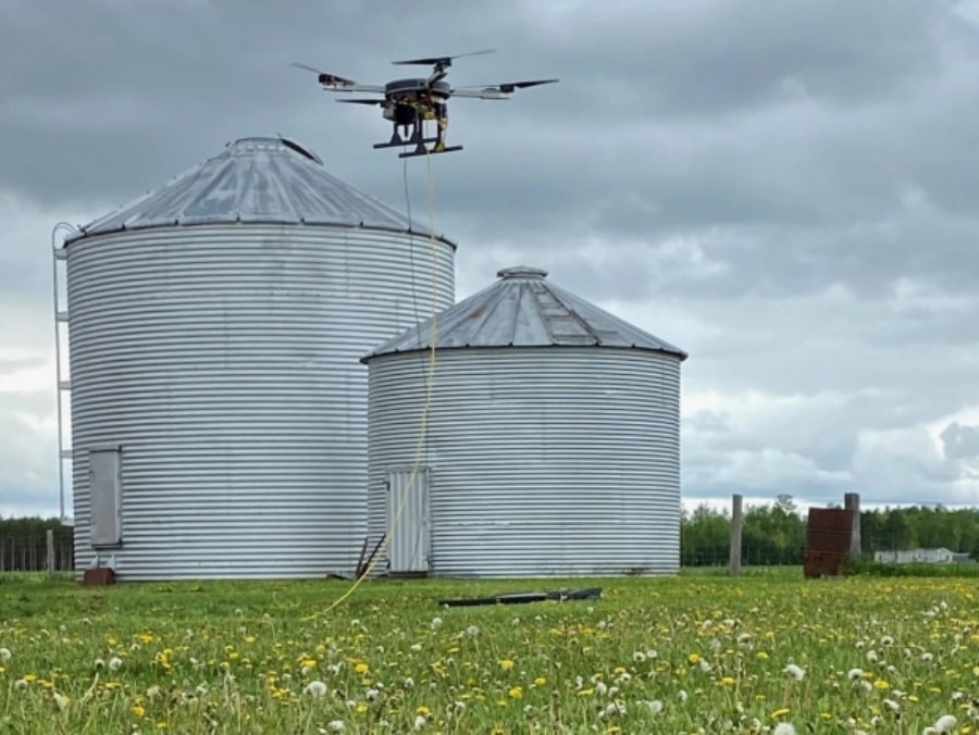
Photo credit: Wisconsin Telelift
The internet-by-drone program will be paid for through a grant of $100,000 awarded by the state of Wisconsin to the school district, so that it can test ways to expand internet access in rural areas.
The drones used in the program will be provided by Wisconsin Telelift (or WiscLift), a Wisconsin-based startup, which will create a school network that students can tap into from home through a drone-powered cellular signal.
How Does It Work?
In order to use drones to bring the internet to students, WiscLift outfits them so they essentially become flying cellphone towers.
The drones can then boost cell signals in the surrounding area, making signals strong enough for students to establish reliable connections that aren’t possible with existing infrastructure.
Keeping the drones in the air for long periods of time is crucial to making this approach to connectivity work—and by long we don’t mean hours, but rather days, or even weeks.
How long, exactly, can these drones stay in the air? Up to 42 days, according to the company’s founder:
We now have this aircraft that has 160 pounds of lifting thrust, and we can fly it for 42 days. It’s so advanced that people still believe it can’t be done, even though we’re doing it.
– Scott “LB” Williams, Founder of Wisconsin Telelift
These long flight times require a lot of energy, and are only possible through the use of power cord tethers, which connect the drone to a ground-based generator. The tethers are made of standard 18 gauge wire and carry a 400V DC current.
Using a tether, a WiscLift drone can stay in the air for a month or more, even through harsh weather, providing a strong, reliable signal the whole time.
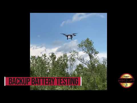
In the event of power loss—say, if the tether is disconnected for some reason—the drones are programmed to switch to a backup battery and land automatically, avoiding the danger that could be presented if one of these huge machines were to fall suddenly from the sky.
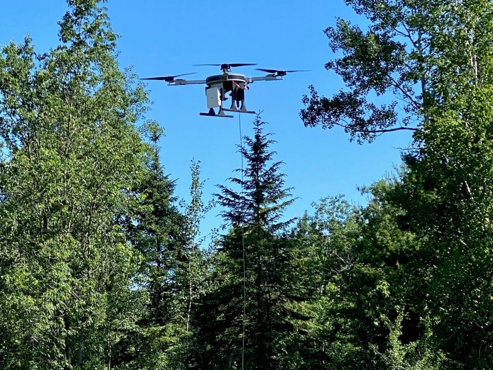
Photo credit: Wisconsin Telelift
Although they could hypothetically be in the air all the time, for the immediate future the drones will only go up in the evenings so that students can access school VPN networks. They’ll also be used on snow days or in other instances where students are at home and need the internet for virtual learning.
Eventually, according to WiscLift founder Scott Williams, the service could become a part of emergency response planning, with WiscLift drones ready to be deployed for cell service when a natural disaster takes out local cellular sites. WiscLift drones could also help boost networks during peak traffic periods, such as when a local sporting event has everyone clustered in one place, all using their phone and data signals at once.
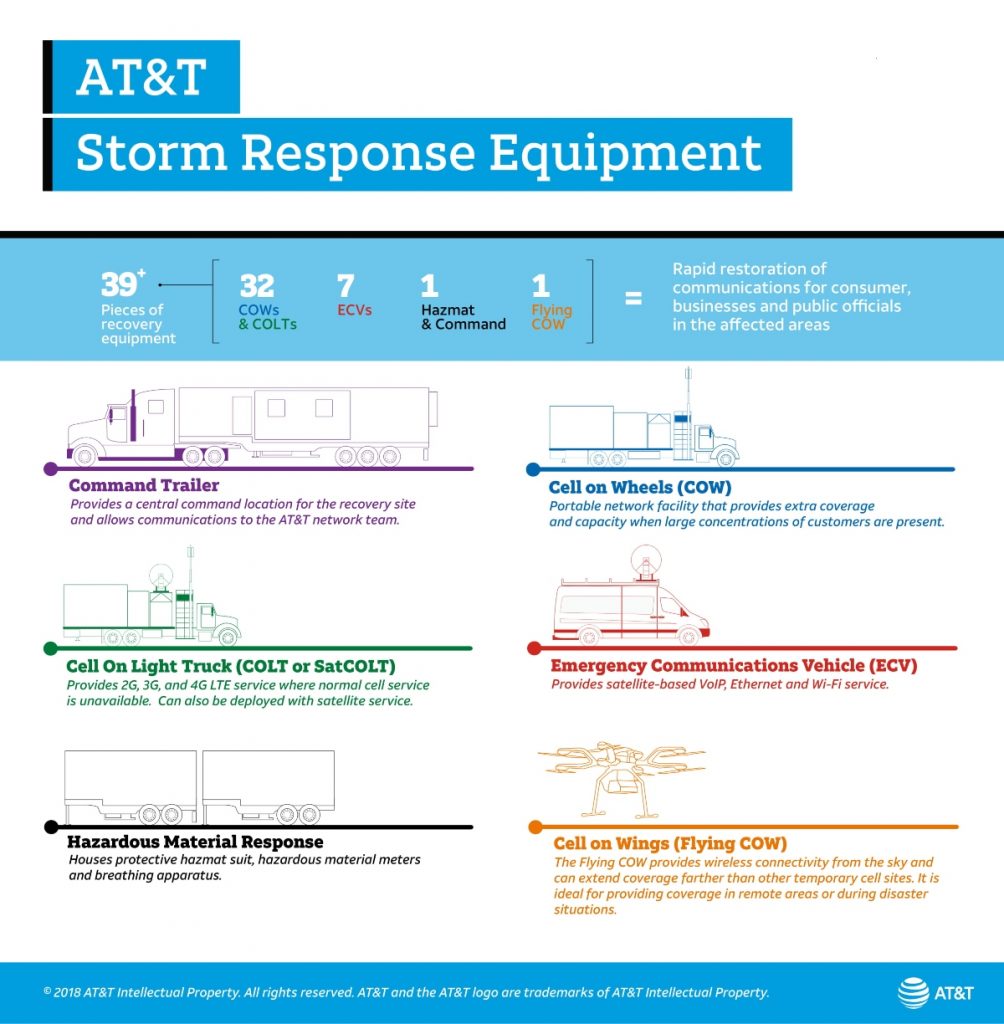
AT&T’s Drones for Natural Disasters
Using drones as flying cell towers in the wake of natural disasters is something AT&T has actually been doing for a while now.
Back in 2017, AT&T deployed its Flying COW (Cell On Wings) drones in Puerto Rico following the damage wrought there by Hurricane Maria. After the hurricane destroyed 37% of the island’s cellular sites, the Flying COWs were able to restore cell service to 80% of AT&T’s customers.

The Flying COWs helped out again in 2018, when Hurricane Michael—at that time the third-most intense Atlantic hurricane to make landfall in the U.S.—wrecked cellular infrastructure throughout the Florida panhandle, leaving thousands without service.
Now in 2021, this technology has gone far beyond the testing phase. AT&T has a robust plan of action for using drones and supporting equipment to get people back online quickly after a natural disaster.
Check out this infographic highlighting the company’s Storm Response Equipment:
But a robust response like this may not be available for smaller areas impacted by less severe weather—which is to say that Williams is probably right when he imagines a future where rural areas could benefit from his drone network services.
While AT&T may call in the big dogs to address the kinds of massive outages caused by hurricanes, we might need to rely on startups like WiscLift to support smaller communities facing similar needs.
The Need for Internet Access in Rural Areas
Limited internet access in rural areas is a persistent problem many people—both students and adults—face throughout the U.S.
A report issued last December by Wisconsin’s Office of Rural Prosperity underscored rural internet access as a top priority for enabling rural economic development.
In the Northland Pines district about 15% of the students, or 200 out of 1,340, don’t have the internet at home, and 50% have poor connections that don’t support video streaming or many types of educational software.
Not only is it an issue that some students can’t afford to buy broadband at their house. It’s actually not available for a lot of people.
– Scott “LB” Williams, Founder of Wisconsin Telelift
The district gives students Chromebooks and portable hotspots to try and support them, but the hotspots only work with a strong cellular signal, which hasn’t been available to many students up to this point.
Now, with WiscLift’s drone program, these students will be able to use their hotspots. And they may also be providing a model for how the internet can be brought to other rural areas throughout the U.S.
Excited to hear about students getting more access to the internet thanks to drones? Share your thoughts in this thread on the UAV Coach community forum.


