

Drones Help Clean Up Plastic-Polluted Rivers, Could Provide Solution to Significantly Reduce Pollution in Oceans
BY Zacc Dukowitz
10 June 2020Much of the trash in the ocean gets there by way of rivers.
To make this concrete, ten of the biggest rivers in the world collectively contribute as much as 95% of the plastic found in the ocean.
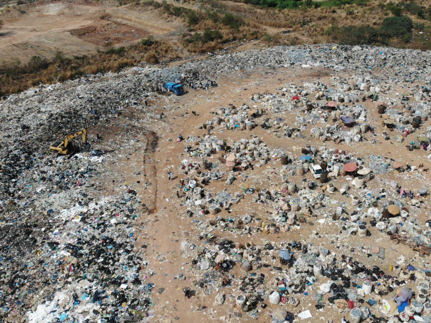
Photo credit: United Nations Environment Program
Scientists from Australia’s Commonwealth Scientific and Industrial Research Organisation (CSIRO) have been working on a massive global plastic pollution survey at sites around the world to better understand the problem so that they can work to find effective solutions.
Five of these research sites are located along the Mekong River in South-East Asia, as well as along the Ganges River in India.
Although these rivers are far from Australia, researchers have observed that a plastic bottle tossed into the Mekong or some other major river has a good chance of eventually making its way to the shores of Australia—or of other countries, such as the U.S., for that matter.
How Drones Are Helping Fight Plastic Pollution
Before large scale efforts can be made to prevent and clean up plastic pollution, researchers first want to identify the major hot spots where the pollution originates.
To do this, researchers would usually conduct a manual survey of plastic pollution along a river like the Mekong, working on land to collect data on where pollution is coming from and where it is concentrated in order to better understand the problem.
Photo credit: United Nations Environment Program
Given the vast size of the Mekong—it runs for about 2,500 miles through six countries, starting in China and ending in Vietnam, where it flows out into the South China Sea—this kind of undertaking is huge, and would typically require hundreds if not thousands of research hours.
But using the DJI Phantom 4, researchers have been able to significantly speed up the process of data collection along the Mekong River by using pictures taken by drone, which will be processed to identify plastic pollution hot spots.
Here is how it works:
- Researchers use drones to capture huge amounts of raw visual data (i.e., pictures) along the Mekong River (or any river where this kind of survey is being conducted).
- These images are processed using special software to identify individual pieces of plastic within them.
- Each one of these individual pieces of plastic is geo-tagged with a specific location.
- Researchers feed the geo-tagged location of every piece of plastic photographed into a giant database.
- Machine learning algorithms process this data, producing the location of plastic pollution hotspots along the river.
By allowing researchers to collect and process huge amounts of data, drones and drone software are saving researchers huge amounts of time, thereby revolutionizing data processing for these kinds of environmental problems.
Researchers estimate that using drones to collect visual data will reduce the amount of time needed to complete the survey and produce hot spot maps by as much as 90%, completing the work in just one year instead of five or ten.
If we were trying to assess the plastic pollution leakage sites or sources that we’re looking at today with traditional methods, we could do surveys that could take five or ten years. With the technology that we have now, we’re able to get that information within a year or less.
– Adam Hodge, Regional Information Officer, United Nations Environment Program
The algorithm CSIRO researchers are working on uses open source data, including river flows and population density, to help not only identify hot spots but also to figure out where and why plastic enters the river at certain places.
After finding these hot spots, researchers will begin working to form localized solutions which, once implemented, will present models for scaling prevention and cleanup efforts to other locations and rivers.
The ultimate goal is to help reduce the amount of plastic pollution in the world’s oceans.

Photo credit: United Nations Environment Program
Other Areas Where Drone Mapping Is Making a Big Impact
Creating maps of hot spots for plastic pollution is just one instance of drone technology making a big difference in the time it takes to do a job.
Here are some other ways drones are helping make mapping more efficient across various industries and uses:
- Accident reconstruction. Drones are helping law enforcement and investigators significantly speed up the creation of 3D maps and orthomosaics for accident reconstruction, reducing a two to three hour process to just five to eight minutes.
- Industrial inspections. Whether inspectors are flying inside a boiler to monitor corrosion or flying outside to inspect a cell phone tower, drones are helping make the process much faster. In the case of indoor inspections, drones help speed things up by allowing for the quick collection of visual data and also by making it so inspectors don’t have to spend time building scaffolding to support their inspections, in some cases reducing the time needed for collecting visual data from three to four days to just a few hours.
- Volcanology. Because of their size and because of the danger presented by being near them when active, volcanoes are incredibly hard to map. Drones are helping researchers speed up the process of creating 3D maps of volcanoes, in some instances collecting new information that has led to discoveries that would have been impossible to make without aerial data.
- Humanitarian Research. Drones are helping humanitarian organizations to significantly speed up their investigations of war crimes. Human Rights Watch (HRW) recently released a report about its work in Syria to create 3D maps of the al-Hota Gorge, the site of a mass grave used by ISIS. HRW used Parrot’s ANAFI to quickly collect visual data for the creation of these maps. Manually walking the gorge to collect similar data would have taken much longer, and, in some instances, would have been impossible given the treacherous nature of the landscape.
This list is not exhaustive by any means.
Do you know of some unique fields where drone mapping is making a big difference? Let us know by chiming in on this thread in the UAV Coach community forum.


