

The Top 17 “Drones for Good” Stories from 2024
BY Zacc Dukowitz
31 December 2024Today is the last day of 2024. And what a year it’s been!
One of our favorite things to do at the end of each year is look back at all the ways drones were used for good.
A drones for good story could be about how drones helped save someone’s life, or how they helped innovate or reduce the need for people to work in dangerous environments. It could also be about how drones have been used to create art and spark joy in the world.
Keep reading for all our favorite drones for good stories from 2024.
1. Autonomous Drone Swarms Inspired by Animal Movements

Credit: Eötvös Loránd University
This year Hungarian researchers at Eötvös Loránd University developed a groundbreaking system of autonomous drone swarms, drawing inspiration from the collective behaviors of animals.
The swarm consists of 100 drones, each capable of real-time decision-making without the need for centralized control or pre-programming. This innovation allows the drones to operate collaboratively, adapting to changing environments and tasks dynamically. By mimicking natural behaviors observed in bird flocks, fish schools, and insect swarms, the drones can navigate complex environments efficiently. This approach has enormous potential for applications like meteorology, land surveying, search-and-rescue missions, and precision agriculture, where large-scale, adaptable operations are crucial.
LEARN MORE
2. Seed-Dropping Drones Combatting Deforestation in Kosovo

In 2024, an innovative project in Kosovo employed seed-dropping drones to tackle the country’s deforestation crisis. The drones, equipped with biodegradable seed pods, are designed to plant thousands of trees in areas that are hard to access by traditional methods.
The initiative focuses on restoring ecosystems impacted by logging and wildfires. Each drone can plant over 10,000 seed pods per day, significantly accelerating reforestation efforts while reducing costs and labor requirements. Early results show promising germination rates, offering hope for faster forest recovery.
LEARN MORE
3. Drones Airlifting Waste from Mount Everest

Mount Everest has long struggled with the environmental toll of increasing tourism, leaving behind significant amounts of waste on its slopes. In 2024, a new initiative used DJI’s heavy-lift FlyCart drones to airlift trash from hard-to-reach areas of the mountain, revolutionizing cleanup efforts.
These drones, capable of carrying up to 100 pounds per trip, can operate at extreme altitudes where traditional methods are dangerous and inefficient. By removing tons of waste from the mountain, this program is helping to preserve Everest’s natural beauty while raising awareness about the environmental impact of high-altitude tourism.
LEARN MORE
4. Drones Assisting in Search and Rescue Operations in Scotland

In 2024, Scotland’s search and rescue teams incorporated advanced drones into their operations, significantly improving response times and success rates. These drones are equipped with thermal imaging cameras, allowing rescuers to locate individuals in remote or rugged terrain, even in low-visibility conditions.
The drones have proven invaluable in locating missing hikers and climbers in the Scottish Highlands, where weather and terrain often complicate traditional rescue efforts. By providing real-time aerial data, these drones are saving lives and ensuring faster interventions in emergencies.
LEARN MORE
5. Drones Deployed to Fight Invasive Weeds in Australia’s River Systems

Credit: XAG
In 2024, Australian environmental agencies partnered with drone companies to combat invasive aquatic weeds that are choking vital river systems. Drones equipped with advanced sensors and spraying technology are being deployed to target and eradicate weeds like salvinia and water hyacinth, which threaten biodiversity and water quality.
The drones’ ability to access hard-to-reach areas along rivers has significantly improved efficiency compared to traditional methods, like manual removal or boat-based spraying. Using precise mapping data and herbicide application, the drones minimize environmental impact while effectively managing weed outbreaks. This innovative approach is expected to save millions in labor costs and help restore ecosystems critical to Australia’s waterways.
LEARN MORE
6. Drones Enhancing Humanitarian Relief in Haiti
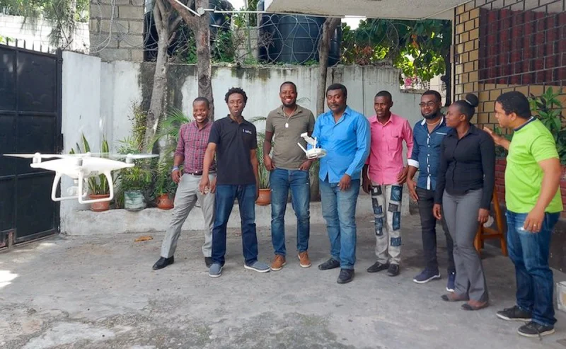
Credit: Haiti Flying Labs
Drones played a critical role in delivering humanitarian aid to Haiti this year, a nation still recovering from recent natural disasters and political instability. Following a series of severe floods and landslides in the summer, drones were deployed to deliver emergency supplies to remote, cut-off regions. Organizations like World Food Programme (WFP), Haiti Flying Labs, and local NGOs leveraged drones to distribute food, water, and medical supplies to communities in urgent need.
The drones’ ability to bypass impassable roads and deliver supplies directly to affected areas drastically reduced response times. In addition to delivering aid, drones equipped with high-resolution cameras conducted aerial surveys to assess the extent of the damage, providing valuable data to coordinate relief efforts more effectively.
This year’s efforts in Haiti underscored how drones can augment traditional humanitarian operations by improving efficiency and reaching isolated communities quickly.
LEARN MORE
7. Drones in Disaster Relief in Japan

Credit: Japan UAS Industrial Development Association
In 2024, drones were at the forefront of disaster relief efforts in Japan after a series of devastating typhoons wreaked havoc across coastal regions.
With roads and infrastructure severely damaged, emergency teams deployed drones to deliver essential supplies such as food, medicine, and clean water to stranded residents. Organizations like The Red Cross and local disaster response agencies used drones to reach areas cut off by landslides and flooding.
Apart from delivering supplies, drones equipped with thermal imaging cameras played a vital role in search and rescue missions, locating survivors trapped under debris or stranded in remote areas. Advanced mapping drones also provided detailed aerial images to assess damage and prioritize recovery efforts, enabling authorities to allocate resources more effectively.
LEARN MORE
8. Record-Breaking Drone Art Installation in Saudi Arabia

As part of the Noor Riyadh Festival, the art collective DRIFT orchestrated a mesmerizing display titled “Desert Swarm,” using 3,000 drones to emulate the fluid movements of bird murmurations over the desert landscape. This large-scale installation set a new world record and captivated audiences with its blend of technology and natural inspiration.
LEARN MORE
9. Drone Helps Rescue Colorado Teen
In May 2024, the Lakewood Police Department in Colorado used a drone to save the life of an intoxicated teenager. Responding to reports of a group of intoxicated juveniles near the Colorado Mills Mall, officers learned that one teen had wandered off into a large, unlit field and was missing.
To expedite the search, law enforcement deployed a thermal drone to look for the teen’s heat signature. The drone quickly located the missing teen lying in the brush, unresponsive and not breathing. Guided by the drone’s live feed, officers reached the teen’s location and immediately administered CPR, successfully resuscitating him.
LEARN MORE
10. Hurricane Helene Disaster Response

Credit: Censys Technologies
In the aftermath of Hurricane Helene, drones played a pivotal role in disaster response efforts across the southeastern United States.
Their versatility and rapid deployment capabilities were instrumental in various critical operations:
- Stringing utility lines to restore power. Drones facilitated the rapid restoration of power by assisting in the deployment of utility lines, especially in areas where traditional methods were hindered by debris and flooding.
- Providing connectivity in areas with damaged communication infrastructure. In regions where communication networks were compromised, drones helped establish temporary connectivity, enabling coordination among relief teams and communication with affected residents.
- Inspecting infrastructure for damage assessment. Equipped with high-resolution cameras, drones conducted aerial surveys to assess damage to roads, bridges, and buildings, providing essential data to prioritize repair efforts.
- Conducting search and rescue operations. Drones with thermal imaging capabilities were deployed to locate missing persons, enhancing the efficiency and safety of search and rescue missions.
- Delivering essential supplies to affected areas. In isolated communities cut off by flooding, drones transported life-saving supplies, including food, water, and medical kits, ensuring timely aid to those in need.
The integration of drone technology into disaster response operations during Hurricane Helene significantly enhanced the effectiveness and speed of relief efforts, underscoring the growing importance of drones in emergency management.
LEARN MORE
11. DIY Disaster Response Vehicles
It wasn’t just first responders that used drones to help with disaster recovery efforts after Hurricane Helene.
In the wake of Hurricane Helene, innovative farmers in North Carolina transformed their ag drones into vital disaster response tools. By attaching modified shopping carts to drones, they created makeshift vehicles capable of delivering essential supplies to areas rendered inaccessible due to flooding and debris.
One notable example is Surry County native Preston Cave, who, along with a team of drone operators, repurposed drones typically used for spraying crops. They adapted shopping carts to carry supplies, enabling the drones to transport goods over obstacles like rivers and damaged roads. This ingenuity ensured that isolated communities received much-needed assistance during the crisis.
LEARN MORE
12. Sky Elements’ Pioneering Pyro Drone Show

In May of this year, Texas-based Sky Elements became the first U.S. drone light show company to receive FAA approval to attach fireworks to drones, introducing a groundbreaking fusion of aerial light displays and pyrotechnics.
This innovation marked a significant advancement in entertainment technology, offering audiences a synchronized spectacle of drones and fireworks. The inaugural show (shown in the video above) featured 300 drones equipped with pyrotechnic devices, creating intricate patterns and vibrant explosions in the night sky.
LEARN MORE
13. Exchange Student Believed Kidnapped Found with a Matrice 30T
This year, the story of a foreign exchange student from China being kidnapped in Utah made national news. It turns out the student was “cyber kidnapped.” That is, he wasn’t actually kidnapped, but his parents in China were receiving threats online from kidnappers who said they had the boy and would hurt him if they didn’t receive a ransom. In reality, the student was being controlled by these “cyber kidnappers,” who had told him to go to a remote area and camp there in the snow so it would look like he’d been kidnapped. The story came to a conclusion when police used a Matrice 30T to look for a heat signature in the snow, finally finding the boy and bringing him home safe to his host family.
LEARN MORE
14. Baby Humpback Whale Swims Around Mother in Beautiful Drone Footage
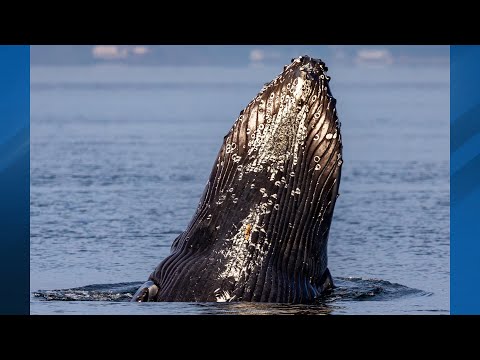
This drone video of a baby humpback whale literally swimming circles around its mother made our hearts smile this year, earning its place in this list of drones for good stories.
The footage was shot by drone videographer David Cope near Point Defiance, Washington at the start of 2024. Want some good news? After years of population decline due to commercial whaling—their numbers were cut by 95% until whaling was outlawed in 1985—humpbacks are slowly making a comeback. More and more, you’ll find an abundance of humpbacks along the west coast, including the coast of Washington state, where this video was shot.
LEARN MORE
15. Alaska DOT Expands Use of Drones to Control Avalanches
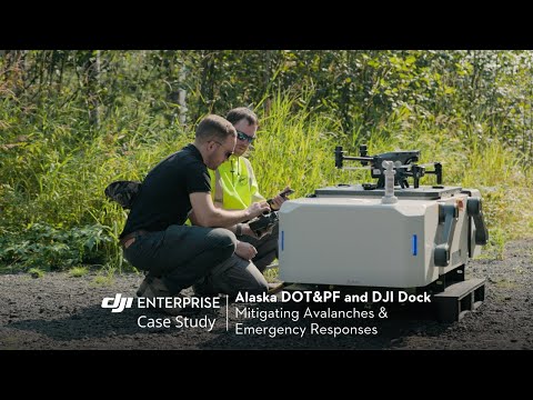
The Alaska DOT was testing the use of drones in remote locations for avalanche detection and mitigation throughout this year. Some of these tests have involved the DJI Dock and Matrice 30, DJI’s first drone-in-a-box solution, which has allowed the agency to continuously collect aerial data on avalanche hazards without a pilot present.
These tests are being done through a partnership between the ADOT and the Alaska Railroad Corporation. Using U.S.-made drones designed to carry and drop payloads, a team dedicated to reducing avalanches has been dropping explosives on hazard areas. Two tests have been carried out so far, with the explosives intentionally triggering avalanches, helping avoid potential disasters in the future.
LEARN MORE
16. Biggest Wave Ever Surfed Measured by New Drone Technology
View this post on Instagram
This is a great example of how a little creative thinking + drones can come up with something incredible.
This year, pro surfer Sebastian Steudtner surfed what may be the biggest wave ever. The feat took place in Nazaré, Portugal on a wave measuring 93.73 feet in height (28.57 meters). The height of the massive wave he surfed was measured using new drone technology developed by Porsche Engineering and Steudtner.
The drone is designed to measure all areas of the wave and the surfer within a radius of about 328 feet (100 meters), allowing it to quickly and precisely determine the height of waves. Wave measurement for surf competitions is typically done with video and photos—if Porsche’s new technology works, it could be adopted throughout surfing to support judging, which means drones could become an integral part of surfing worldwide.
LEARN MORE
17. Drone Pilot Helps Rescue Capsized Kayaker

A kayaker waits to be rescued in the open ocean | Credit: Mike Busch
This year a drone pilot in Long Island helped save a kayaker who had capsized in Moriches Inlet. The pilot was drone photographer Mike Busch, who had come to the beach that day in the hopes of capturing aerial shots of seals.
After he’d been there a while, a kayaker paddled up to the shore and asked Busch if he’d seen another person in a kayak. Busch put his drone in the air and soon spotted a kayaker being pulled out to sea. Acting quickly, he called 911, hovering over the kayaker to track their location until rescue personnel arrived and saved them.


