Drones in Civil Engineering: How Drones Help Taylor Engineering Protect and Preserve Coastal Areas

BY Zacc Dukowitz
18 June 2020

By now, most of us are already familiar with the ways that drones are supporting commercial operations in major industries like construction, agriculture, or inspections.

But as drones become mainstream, the number of use cases is skyrocketing, as are the instances of drones being used for good.

This week we learned about the drone program at Taylor Engineering, Inc., a civil engineering firm based in Jacksonville, Florida that does work throughout the East Coast, among other locations.

[Related reading: Drones Help Clean Up Plastic-Polluted Rivers]

The focus of the firm’s work is on civil engineering projects related to the water environment. Some of the most common types of projects they do are coastal restoration, coastal protection, flood management, water risk management, and dredging.

We wanted to learn more about how the firm uses drones in its work so we spoke with William Warren, Staff Geologist and Remote Sensing Practice Area Leader at Taylor Engineering. William is also the founder of the firm’s drone program and the first Part 107-certified pilot on its payroll.

When did you start your drone program?

We started our drone program in 2017.

That year we purchased our first Phantom 4 Pro, which we used to monitor progress on a big dredging and restoration project [this project is covered in the first case study below].

The results of that first effort with the drone were so impressive that they served as a solid proof of concept internally, and the drone program really took off after that.

In 2018, we established a Remote Sensing Practice Area where we conduct training for our remote pilots.

Since then, we’ve gone from just me holding a Part 107 certificate within the firm to now having eight FAA certified pilots on our team.

How do you use drones in your civil engineering work?

We use drones for four major purposes:

  • Progress and monitoring. Using still images and orthomosaics to show progress and monitor the construction site, both internally and for client updates.
  • Site mapping. Creating orthomosaic maps of the site.
  • Topographic maps and stockpile volumetry. Tracking changes in elevation or changes to stockpiles of materials, such as sand, using set ground control points (GCPs).
  • Marketing. Showcasing our work using aerial images, both to provide vivid before-and-after examples and for single shots to demonstrate the end results of our work.

These four uses represent a significant evolution from when we first incorporated drones into our work.

In the early days of our drone program, we really just used drones to monitor progress on our construction projects. If the project is big—and most of them are, with what we do—then aerial shots can really help show change over time.

As our drone program evolved, we went from collecting still images to collecting orthomosaic images for project monitoring, and then to using ground points for the creation of topographic maps and stockpile volumetry.

What kinds of drones do you currently have in your fleet?

All of our drones are versions of the DJI Phantom 4 Pro.

We have two Phantom 4 Pros, a Phantom 4 Pro V2, and a Phantom 4 Pro RTK.

Civil Engineering Case Studies from Taylor Engineering

Here are three short case studies showcasing the ways that William and his team at Taylor Engineering use drones in their work.

1. Norriego Point Restoration Project

The goal of this project was to restore Norriego Point in Destin, Florida using material dredged from the adjacent navigation channels. The project resulted in restored channels for safer navigation and provided added storm protection for Destin Harbor.

The client for the project was the Florida Department of Environmental Protection.

How Drones Helped

Using a Phantom 4 Pro, images were taken throughout the project to show how both the dredging and the beneficial use of sediment were progressing.

Check out the before and after images shown below, documenting the restored footprint of Norriego Point along with the dredging progress seen in the water’s shifting coloration, from a light to a much darker color.

drones-civil-engineering-destin-before
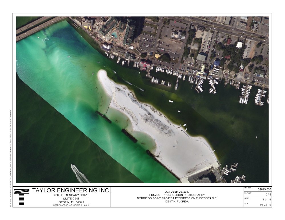
Before restoration and dredging

drones-civil-engineering-destin-after
After restoration and dredging

2. Fort Pierce Truck Haul Shore Protection Project

The goal of this project was to protect the shoreline in Fort Pierce, Florida. Civil engineers from Taylor Engineering designed a beach fill template that provided a specific elevation requirement for the beach berm. Sand from an upland mine was used to construct the beach meeting design requirements.

The client for the project was the St. Lucie County Erosion District.

How Drones Helped

Drones helped by providing progress aerials that were used both internally and provided to the client as updates. These aerials were also used for marketing materials.

Another output created from drone data on this project was a topographic map, which was used to compare the actual beach elevation with the project design specifications in order to ensure that the elevation requirements for the project were met.

drones-civil-engineering-fort-pierce-shoreline
An aerial shot showing progress on the Fort Pierce Shore Protection Project

drones-civil-engineering-fort-pierce-elevation-map
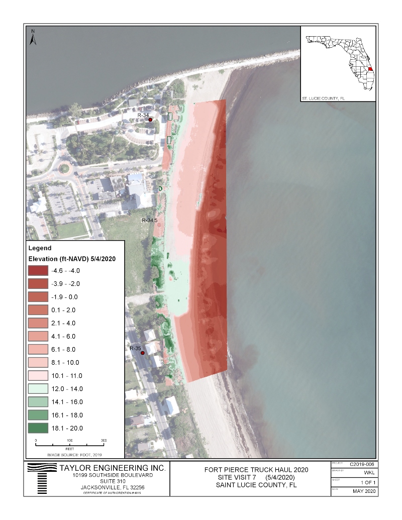
An elevation map of the Fort Pierce Shore Protection Project

3. DU-2 Offloading Project

The goal of this project was to monitor the offloading of dredged sediments from a dredge material management area in Duval County, Florida. Dredging had already been completed, and a contractor wanted to use the resulting material. Taylor Engineering’s job was to collect topographic data in order to monitor the quantity of material removed and to document site conditions for the client.

The client for the project was the Florida Inland Navigation District.

How Drones Helped

Drones helped monitor the contractor’s offloading progress and also to document pre- and post-offloading site conditions.

Aerial images were also used to create orthomosaics with GCPs to monitor the volume of material removed from the site.

Both the oblique images and the orthomosaics were used internally, to track the project, and for the client, to provide them with clear updates on how things were progressing.

drone-civil-engineering-du2-offloading
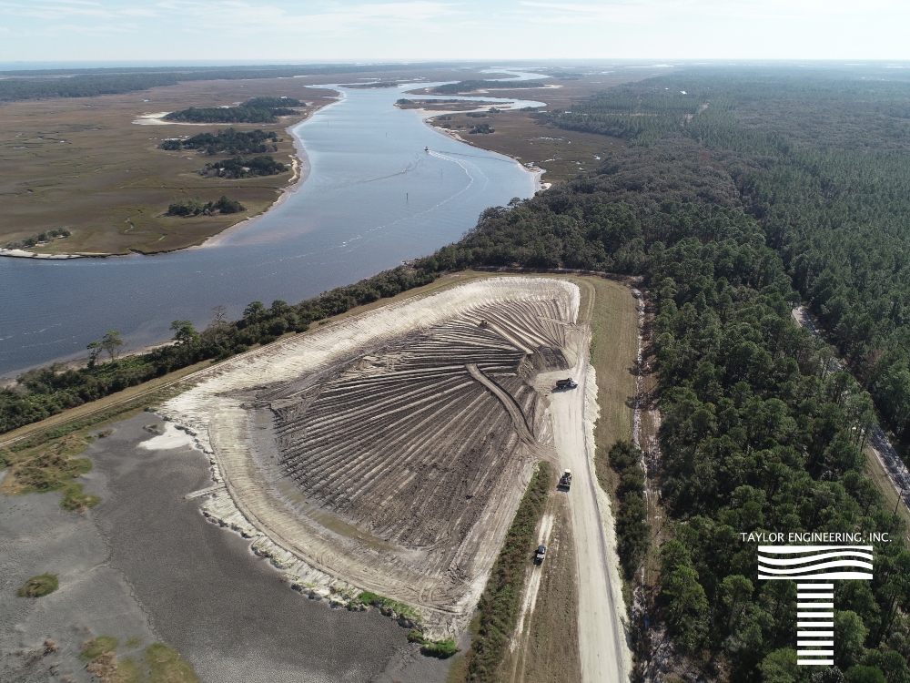
Aerial shot of the DU-2 Offloading site

Do you know of any other civil engineering use cases for drones? Chime in here on this thread in the UAV Coach community forum.

Join a global community of

100,000+

drone enthusiasts.

Subscribe

Drone Pilot's Guide to DJI Mini 4 Pro

  • Navigate the DJI Fly app and flight modes with ease
  • Adjust camera and safety settings for better control
  • Understand intelligent flight features and how to use them
  • Avoid common beginner mistakes
  • Get the most out of your drone—without the guesswork

Drone Pilot's Guide to DJI Air 3S

  • Navigate the DJI Fly app and flight modes with ease
  • Adjust camera and safety settings for better control
  • Understand intelligent flight features and how to use them
  • Avoid common beginner mistakes
  • Get the most out of your drone—without the guesswork

Hands-On Flight Training

$295

400+ 5-Star Reviews

  • Team up with a knowledgeable, friendly instructor at a convenient outdoor spot — like a park or athletic field
  • Fly a top-rated drone provided for you, or bring your own to get personalized guidance
  • Spend most of your time in the air with hands-on practice — learning about composition, camera angles and cinematic motion
  • Explore the DJI Fly app and learn how to use camera settings like ISO, shutter speed and aperture
  • Unlock the power of Intelligent Flight Modes to fly smoother, smarter, and with less stress
  • Get access to our Aerial Photo & Video online course with additional exercises and pro-level editing workflows – using Snapseed, Photopea, Adobe Lightroom, DJI LightCut, and Premiere Pro

Aerial Photo & Video for Drone Pilots

$179

3,500+ 5-Star Reviews

  • How to dial in the right camera settings like ISO, shutter speed, and aperture
  • The best angles & altitudes for different types of shots (real estate, landscapes, cityscapes, and more)
  • The secret to cinematic drone motion that makes your footage feel like a Hollywood movie
  • How to enhance colors, remove distractions, and sharpen details – even in tricky lighting
  • Pro-level editing workflows – whether you’re using Lightroom, free tools, or mobile apps

The Recreational UAS Safety Test

Free

150+ 5-Star Reviews

  • Required for U.S. recreational flyers of drones
  • Launched June 2021 by the FAA
  • Takes about 30 minutes to complete
  • No prior drone knowledge needed
  • Test allows unlimited attempts to pass

Drone Mapping Essentials Workshop

$799

3,500+ 5-Star Reviews

  • Expert instruction from expert drone pilots with over 100 hours of flying experience
  • Hands-on training of live data capture and how to process deliverables for your clients
  • Peer-to-peer networking with other professional drone pilots in the mapping industry
  • Free access to the online course, Drone Mapping Essentials

Flight Skills for Drone Pilots

$99

75+ 5-Star Reviews

  • 16 engaging video lectures with key takeaways
  • Action items with concrete steps so you put into practice what you learn
  • Pre-flight checklists to help you plan your flights
  • Resource links to websites, products and software for further learning and discovery

Drone Business & Mapping Bundle

$617 $397

3,500+ 5-Star Reviews

  • Drone Pilot Ground School
    1. 1:1 support with a Part 107 exam success coach
    2. Study 100% online at your own pace
    3. Unlimited practice exams with 400+ real FAA test questions
  • Drone Mapping Essentials
    1. 100+ instructional videos focused on real-world application with high-quality videos
    2. Downloadable resources like data capture checklists to utilize in your missions
    3. Monthly live instruction with course instructor, Dylan Gorman, to go deeper on topics where you need more clarification
  • The Drone Business Blueprint
    1. Expert instruction from industry veteran, Eno Umoh, who brings real-world experience in building successful drone businesses.
    2. 14 Comprehensive modules covering everything from business setup to marketing strategies
    3. 30 Downloadable resources to apply your learning immediately

Hands-On Flight Training

$295

400+ 5-Star Reviews

  • 45-60 minutes of hands-on flying time to master orientation and flight maneuvers tailored to your skill level
  • Learn how to handle obstacles such as lost GPS, low battery charge or emergencies
  • Practice flying under various intelligent flight modes
  • Ask questions about regulations, software, flight operations management, and more

The Drone Business Blueprint

$119

3,500+ 5-Star Reviews

  • Expert instruction from industry veteran, Eno Umoh, who brings real-world experience in building successful drone businesses.
  • 14 Comprehensive modules covering everything from business setup to marketing strategies
  • 30 Downloadable resources to apply your learning immediately
  • AI tools and techniques to boost productivity and streamline your operations

Commercial Drone Business Bundle

$418 $334

4,000+ 5-Star Reviews

  • Drone Pilot Ground School
    1. 1:1 support with a Part 107 exam success coach
    2. Study 100% online at your own pace
    3. Unlimited practice exams with 400+ real FAA test questions
  • The Drone Business Blueprint
    1. Expert instruction from industry veteran, Eno Umoh, who brings real-world experience in building successful drone businesses.
    2. 14 Comprehensive modules covering everything from business setup to marketing strategies
    3. 30 Downloadable resources to apply your learning immediately

Drone Mapping Essentials

$199

3,500+ 5-Star Reviews

  • 100+ instructional videos focused on real-world application with high-quality videos
  • Downloadable resources like data capture checklists to utilize in your missions
  • Quizzes to test your knowledge so you can succeed in the field
  • Monthly live instruction with course instructor, Dylan Gorman, to go deeper on topics where you need more clarification

Drone Pilot Pro Bundle

$713 $499

3,500+ 5-Star Reviews

  • Drone Pilot Ground School
    1. 1:1 support with a Part 107 exam success coach
    2. Study 100% online at your own pace
    3. Unlimited practice exams with 400+ real FAA test questions
  • Drone Pilot Skill Builder
    1. 16 engaging video lectures with key takeaways
    2. Action items with concrete steps so you put into practice what you learn
  • Hands-On Flight Training
    1. 45-60 minutes of hands-on flying time to master orientation and flight maneuvers tailored to your skill level

Drone Pilot Ground School

$299

4,000+ 5-Star Reviews

  • 1:1 support with a Part 107 exam success coach
  • Study 100% online at your own pace
  • Unlimited practice exams with 400+ real FAA test questions
  • Personalized study plans, virtual flashcards, and 12-page cram sheet
  • Weekly webinars on acing the Part 107 exam and monthly webinars to elevate your journey post-certification