

Drones in Accident Reconstruction: How Drones Are Helping Make Traffic Crash Site Assessments Faster, Safer, and More Accurate
BY Zacc Dukowitz
4 June 2020Drones are fast becoming a go-to technology for accident reconstruction, used by law enforcement, insurance companies, and lawyers trying to assess blame after a crash.
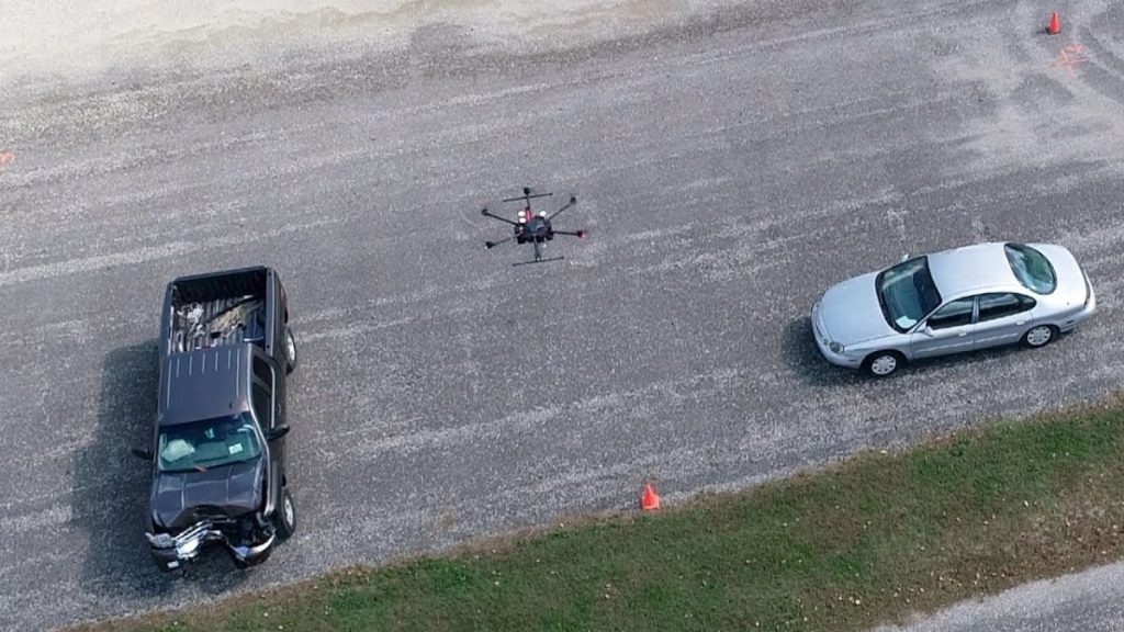
Photo credit: John Bullock and Erin Easterling/Purdue University
One of the biggest values in using a drone for accident reconstruction is that it significantly reduces the amount of time needed to collect a sufficient amount of data to map out the scene for an investigation.
In older approaches for mapping accident scenes, investigators used pencils and tape measures, manually identifying skid marks and important parts of the scene to reconstruct the cause of an accident by marking Xs and Os on graph paper. This kind of accident reconstruction could take anywhere from six to eight hours, meaning long delays for the roadway on which the accident took place.
More recently, laser scanners have been used to help speed up this manual approach. But even with this improvement, accident mapping can still take two to three hours to complete.
Drones offer a speedier, more accurate solution. With a drone, investigators can map an accident scene in just five to eight minutes, according to research done at Purdue University.
And the time saved isn’t just an improvement to the efficiency of the investigation—it can literally help save lives.
[Related read: What Is a Public Safety Drone? An In-Depth Guide—Including 54 Use Cases]
How Drones Help Reconstruct Accidents
Drones help reconstruct accident scenes by collecting visual data that can then be processed using mapping software into 3D models or orthomosaic maps of the scene.

Photo credit: Pix4D
Some common drones used for accident reconstruction are DJI’s Inspire 2 paired with the ZenMuse X7 and the Phantom 4 Pro, but there are many different kinds of mapping drones out there that are also being used.
Accuracy is incredibly important when collecting data to create these maps for the purposes of accident reconstruction, since a relatively small error in the data could make it appear that a different scenario caused the accident, and lay blame for the crash on the wrong person.
Researchers at Purdue University have partnered with the Tippecanoe County Sheriff’s Office, located in Indiana, to study the use of drones for reconstructing accidents. In 2018 alone, the Sheriff’s Office used drones for accident reconstruction a total of 20 different times.
Watch this video for a recap of their research and findings:

How Using Drones for Accident Reconstruction Helps Keep People Safer
When first responders arrive at the scene of a car crash they have four priorities:
1. Make sure the people involved are safe—identifying injuries, and getting medical care for those who need it.
2. Make sure the scene is safe—ensuring that nothing is in danger of exploding, collapsing, or otherwise presenting a danger to those in the area.
3. Secure and collect the evidence—the accident site is not only a place where people need help, it’s also a crime scene that needs to be investigated in order to determine why the accident happened.
4. Working quickly to clear the road—the longer roads are closed due to an accident, the higher the chances that another accident, or several others, may happen.

Photo credit: John Bullock and Erin Easterling/Purdue University
You may have noticed that the third and fourth priorities listed above directly conflict with each other.
On the one hand, first responders are trying to preserve the scene and collect enough evidence to reconstruct the accident, on the other hand, they’re trying to clear the area quickly to avoid further accidents.
Anything that can be done to speed up the collection of evidence can literally save lives, since data shows that the more time the road is blocked, the more likely it is that another accident will occur.
In fact, one of the most dangerous times to be on the road is right after a car accident.
It’s in this window of time that the chance of “secondary accidents”—accidents related to a sudden stop in traffic, like a pileup, or to unexpected debris in the road—go up significantly.
The likelihood of a secondary crash increases by 3% for every minute the primary incident is ongoing. Traffic crashes and struck-by-incidents continue to be one of the leading causes of on-duty injuries and deaths for law enforcement, firefighters, and towing and recovery personnel.
– Andrew Klane, Massachusetts State Troopers
According to data from Purdue University, secondary crashes go up by a factor of 24 right after a crash.
And this is where drones can help.
By significantly speeding up data collection for accident reconstruction, drones are helping investigators clear roads much, much more quickly after an accident, and thereby helping to reduce the potential for secondary crashes.
[Related reading: 6 Ways Police Departments Use Drones in Their Work]
An additional way that reducing time on the road during a crash helps keep people safe is by reducing the amount of exposure first responders themselves have to risk.
The more time a first responder spends on the site of an accident scene, the higher the chances that someone might accidentally hit them.
But it’s not just law enforcement that uses drones for accident reconstruction these days.
Insurance companies have started using drones to better assess insurance claims made by people involved in car crashes. And law firms that specialize in personal injury law related to crashes have also started using drones in accident investigations, in order to create maps for accident reconstruction purposes as well as to create better visuals for juries.
Know of people using drones for accident reconstruction, or have some related information to share? Chime in on this thread in the UAV Coach community forum.


