Drone News Roundup: Flying a Drone at 28,000+ Feet on Mt. Everest, Global Donations of Drones to Ukraine, and More!

BY Zacc Dukowitz
17 March 2022

This week we’re covering a video highlighting drone footage captured at over 28,000 feet on Mt. Everest for a documentary created by National Geographic.

We’re also covering stories about countries around the world donating drones to Ukraine, senseFly’s drone being added to the Blue UAS 2.0 list, the use of drones by Connecticut State Troopers to catch truckers suspected of smuggling illicit goods, and the FAA’s announcement that the application period for LAANC service providers will open soon.

Now on to the links!

Flying a Drone at 28,300 Feet on Mt. Everest

Flying a Drone at 28,300 Feet on Mt. Everest (National Geographic)

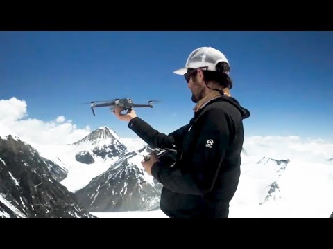
This short clip from the documentary “Lost on Everest” features drone footage shot at over 28,000 feet of altitude on Mt. Everest. The drone allowed explorers to capture aerial footage from the safety of their tent, without having to walk the mountain on foot to get the shots they wanted. According to the documentarians, this was the first time a drone had ever been flown at this height on the mountain. The documentary was made by National Geographic.

LEARN MORE


World Rallies to Send Drones to Ukraine

global-drone-donations-ukraine

Credit: Finnish volunteer group

Countries around the world have been sending support to Ukraine as it fends off the ongoing Russian invasion, including sending drones. Here’s a list of just some of the drone-related donations that have been made recently:

  • In Canada, the government is sending cutting-edge surveillance cameras made for use on military drones to Ukraine.
  • In Finland, a volunteer group raised over $57,000 to buy and hand deliver 140 DJI Mavic Mini drones to the Ukrainian military to help with their reconnaissance efforts.
  • In the Netherlands, a volunteer group called Eyes on Ukraine is sending 187 DJI Mini 2s to be used for aerial surveillance, and to record the actions of the Russian military as evidence of possible atrocities committed. The group plans to continue sending drones “until there are no more drones to buy, or when the Ukrainians indicate that their demand is met.”
  • In Wales, a member of the national legislature named Mick Antoniw of Ukrainian descent sought to raise over $56,000 to buy drones for Ukraine and ended up raising over eight times as much. The money was reportedly used to buy Parrot ANAFI drones, which will “allow medics to identify the injured and fatalities in the rubble and chaos resulting from Russian attacks on civilian buildings.”

LEARN MORE ABOUT HOW UKRAINE IS USING HOBBY DRONES


senseFly eBee TAC Added to Blue UAS Cleared List

sensefly-blue-uas
Credit: AgEagle

senseFly’s eBee TAC has been named to the Department of Defense’s Blue UAS 2.0 cleared list, which are drones approved for use by federal agencies. Over 100 companies responded to the DOD’s call for proposals from drone companies that wanted to participate in Blue UAS 2.0, but only 11 were selected. The Blue UAS 2.0 list was created to “increase the diversity, capability and affordability of UAS” available for government use. AgEagle bought senseFly from Parrot for a reported $23 million last October.

READ MORE


Connecticut State Troopers Use Drones to Catch Truckers Skipping Weigh Stations

ct-state-troopers-drones
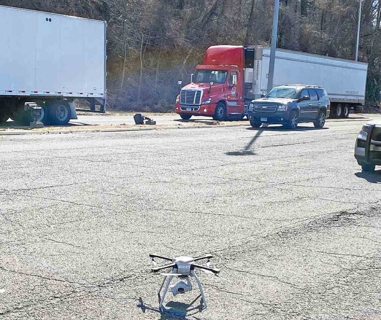
Credit: Connecticut State Police

Connecticut State Police, along with several other partners, recently tested the use of drones to identify truckers who weren’t stopping at a mandatory weigh station in Greenwich, CT. Weigh stations are important checkpoints to help prevent the transportation of illegal or harmful devices and materials, and truckers who attempt to evade inspection are breaking the law. Using a drone, State Police were able to observe trucks trying to skip the weigh station and “divert at the NY-CT state line,” and pull them over.

READ MORE


FAA Announces Application Period for LAANC Service Suppliers

laanc-faa-service-providers

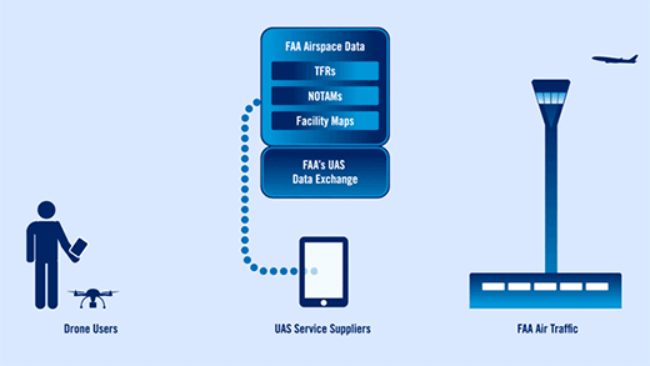
A new application period for LAANC (Low Altitude Authorization and Notification Capability) service providers will open on May 2, 2022. In order to be considered, applicants must have a mature product at the time of application, according to the FAA.

LAANC is the FAA’s system for providing instant airspace authorizations for drone operations in controlled airspace at or below 400 feet. It’s used to inform drone pilots of where they can and can’t fly, and to alert air traffic personnel regarding where and when drones are operating in the area.

At the moment, there are eight LAANC providers: Airbus, AirMap (via DroneUp), Airspace Link, Aloft (via the FAA’s B4Ufly app), Avision,  Skyward, UASidekick, and Wing.

Here is the application schedule for companies who want to become LAANC service providers:

  • Application Period: May 2—June 3, 2022
  • FAA Submission Review: June 6—July 8, 2022
  • Technical Interviews: July 11—August 12, 2022
  • Formal Onboarding: August 18—October 14, 2022

READ MORE


Make sure to sign up for our free weekly newsletter using the button below so you can get our weekly newsletter every Saturday, with this roundup and our other featured stories from the week.

Join a global community of

100,000+

drone enthusiasts.

Subscribe

Drone Pilot's Guide to DJI Mini 4 Pro

  • Navigate the DJI Fly app and flight modes with ease
  • Adjust camera and safety settings for better control
  • Understand intelligent flight features and how to use them
  • Avoid common beginner mistakes
  • Get the most out of your drone—without the guesswork

Drone Pilot's Guide to DJI Air 3S

  • Navigate the DJI Fly app and flight modes with ease
  • Adjust camera and safety settings for better control
  • Understand intelligent flight features and how to use them
  • Avoid common beginner mistakes
  • Get the most out of your drone—without the guesswork

Hands-On Flight Training

$295

400+ 5-Star Reviews

  • Team up with a knowledgeable, friendly instructor at a convenient outdoor spot — like a park or athletic field
  • Fly a top-rated drone provided for you, or bring your own to get personalized guidance
  • Spend most of your time in the air with hands-on practice — learning about composition, camera angles and cinematic motion
  • Explore the DJI Fly app and learn how to use camera settings like ISO, shutter speed and aperture
  • Unlock the power of Intelligent Flight Modes to fly smoother, smarter, and with less stress
  • Get access to our Aerial Photo & Video online course with additional exercises and pro-level editing workflows – using Snapseed, Photopea, Adobe Lightroom, DJI LightCut, and Premiere Pro

Aerial Photo & Video for Drone Pilots

$179

3,500+ 5-Star Reviews

  • How to dial in the right camera settings like ISO, shutter speed, and aperture
  • The best angles & altitudes for different types of shots (real estate, landscapes, cityscapes, and more)
  • The secret to cinematic drone motion that makes your footage feel like a Hollywood movie
  • How to enhance colors, remove distractions, and sharpen details – even in tricky lighting
  • Pro-level editing workflows – whether you’re using Lightroom, free tools, or mobile apps

The Recreational UAS Safety Test

Free

150+ 5-Star Reviews

  • Required for U.S. recreational flyers of drones
  • Launched June 2021 by the FAA
  • Takes about 30 minutes to complete
  • No prior drone knowledge needed
  • Test allows unlimited attempts to pass

Drone Mapping Essentials Workshop

$799

3,500+ 5-Star Reviews

  • Expert instruction from expert drone pilots with over 100 hours of flying experience
  • Hands-on training of live data capture and how to process deliverables for your clients
  • Peer-to-peer networking with other professional drone pilots in the mapping industry
  • Free access to the online course, Drone Mapping Essentials

Flight Skills for Drone Pilots

$99

75+ 5-Star Reviews

  • 16 engaging video lectures with key takeaways
  • Action items with concrete steps so you put into practice what you learn
  • Pre-flight checklists to help you plan your flights
  • Resource links to websites, products and software for further learning and discovery

Drone Business & Mapping Bundle

$617 $397

3,500+ 5-Star Reviews

  • Drone Pilot Ground School
    1. 1:1 support with a Part 107 exam success coach
    2. Study 100% online at your own pace
    3. Unlimited practice exams with 400+ real FAA test questions
  • Drone Mapping Essentials
    1. 100+ instructional videos focused on real-world application with high-quality videos
    2. Downloadable resources like data capture checklists to utilize in your missions
    3. Monthly live instruction with course instructor, Dylan Gorman, to go deeper on topics where you need more clarification
  • The Drone Business Blueprint
    1. Expert instruction from industry veteran, Eno Umoh, who brings real-world experience in building successful drone businesses.
    2. 14 Comprehensive modules covering everything from business setup to marketing strategies
    3. 30 Downloadable resources to apply your learning immediately

Hands-On Flight Training

$295

400+ 5-Star Reviews

  • 45-60 minutes of hands-on flying time to master orientation and flight maneuvers tailored to your skill level
  • Learn how to handle obstacles such as lost GPS, low battery charge or emergencies
  • Practice flying under various intelligent flight modes
  • Ask questions about regulations, software, flight operations management, and more

The Drone Business Blueprint

$119

3,500+ 5-Star Reviews

  • Expert instruction from industry veteran, Eno Umoh, who brings real-world experience in building successful drone businesses.
  • 14 Comprehensive modules covering everything from business setup to marketing strategies
  • 30 Downloadable resources to apply your learning immediately
  • AI tools and techniques to boost productivity and streamline your operations

Commercial Drone Business Bundle

$418 $334

4,000+ 5-Star Reviews

  • Drone Pilot Ground School
    1. 1:1 support with a Part 107 exam success coach
    2. Study 100% online at your own pace
    3. Unlimited practice exams with 400+ real FAA test questions
  • The Drone Business Blueprint
    1. Expert instruction from industry veteran, Eno Umoh, who brings real-world experience in building successful drone businesses.
    2. 14 Comprehensive modules covering everything from business setup to marketing strategies
    3. 30 Downloadable resources to apply your learning immediately

Drone Mapping Essentials

$199

3,500+ 5-Star Reviews

  • 100+ instructional videos focused on real-world application with high-quality videos
  • Downloadable resources like data capture checklists to utilize in your missions
  • Quizzes to test your knowledge so you can succeed in the field
  • Monthly live instruction with course instructor, Dylan Gorman, to go deeper on topics where you need more clarification

Drone Pilot Pro Bundle

$713 $499

3,500+ 5-Star Reviews

  • Drone Pilot Ground School
    1. 1:1 support with a Part 107 exam success coach
    2. Study 100% online at your own pace
    3. Unlimited practice exams with 400+ real FAA test questions
  • Drone Pilot Skill Builder
    1. 16 engaging video lectures with key takeaways
    2. Action items with concrete steps so you put into practice what you learn
  • Hands-On Flight Training
    1. 45-60 minutes of hands-on flying time to master orientation and flight maneuvers tailored to your skill level

Drone Pilot Ground School

$299

4,000+ 5-Star Reviews

  • 1:1 support with a Part 107 exam success coach
  • Study 100% online at your own pace
  • Unlimited practice exams with 400+ real FAA test questions
  • Personalized study plans, virtual flashcards, and 12-page cram sheet
  • Weekly webinars on acing the Part 107 exam and monthly webinars to elevate your journey post-certification