Drone News Roundup: Journey to the Arctic with the Mavic 3, Holiday Gift Guide, and More!

BY Zacc Dukowitz
7 November 2024

This week we’re covering a journey to the Arctic shot entirely on the Mavic 3.

We’re also covering our newly updated drone holiday gift guide, Voliro’s launch of the T5 inspection drone, San Francisco’s DFR (Drone as First Responder) program, and LiDAR drones helping archaeologists find two ancient cities on the Silk Road.

Now on to the links!

Journey to the Arctic with the Mavic 3

SVALBARD - A Journey to the Edge of the World

Denis Barbas has brought us several world-class drone explorations over the last few years, including a tour of the Dolomites shot on the Inspire 3 and another of Iceland shot on the Mavic 3. Lately, he seems to be obsessed with icy destinations. In this video, Barbas takes us to Svalbard, a remote Norwegian archipelago in the Arctic Ocean. The chain of islands is known for its stunning landscapes of glaciers, mountains, and fjords, and it’s home to the northernmost settlement in the world, Longyearbyen. This drone tour of the area was shot entirely on the Mavic 3 over four different trips, which were taken aboard different boats at different times of the year, letting Barbas get a variety of footage for this serene cinematic video.

LEARN MORE


Looking for Drone Presents? Check Out Our Updated Drone Holiday Gift Guide

Looking for a drone present to buy a loved one? Or maybe for yourself? Just in time for the holiday season, we just did a complete update to our drone holiday gift guide. Gift ideas are listed by price point, ranging from as little as $9 and going up from there. Want to buy someone drone flying lessons? We got you covered. Looking for drone ideas? Here you go. The guide also covers online drone courses, drone travel accessories, and more. Follow the link below to see everything it has to offer.

LEARN MORE


Voliro Unveils the T5 Inspection Drone

Voliro - Introducing Version 5

Fresh off the heels of a successful $12 million Series A fundraising round, Voliro just announced the launch of the Voliro T5, a completely updated version of its flagship inspection drone. Voliro’s drones have omnidirectional capabilities, allowing them to stabilize in air in a variety of positions to collect inspection data. (The stabilization Voliro has achieved is impressive—check out the shot at 1:11 to see what it looks like.) Voliro was the first company to develop an ultrasonic thickness payload for a drone, and it now offers swappable payloads for five different types of inspection methods.

Here’s what’s new in the Voliro T5:

  • 5G connectivity. Enables real-time data transfer and proactive maintenance through the Voliro Cloud.
  • Improved flight controller. Features triple-redundant IMU for enhanced stability and early motor issue detection.
  • Enhanced propulsion. Increased wind resistance and responsiveness with upgraded tail motor and propeller.
  • Weight reduction. Overall design is .55 pounds (250 grams) lighter, improving flight dynamics and extending flight time.
  • Reliability and durability. Redesigned PCBs and high-quality materials enhance system reliability in harsh conditions.
  • Operational benefits. Supports remote flexibility for immediate decision-making based on live data.

LEARN MORE


San Francisco PD Drone Program Helps Catch Thieves in the Act

The San Francisco Police Department (SFPD) has been seeing a lot of success with its DFR (Drone as First Responder) program lately. In a recent presentation, police officials in the city showcased the effectiveness of the technology, demonstrating how drones are being deployed immediately upon receiving reports of potential criminal activity. The department’s drones can reach any part of the city within minutes, often arriving at scenes before ground officers. One recent example that stands out is the case of a suspect breaking into a car and stealing bicycles. Using a drone, police were able to track and ultimately apprehend the suspect in real time.

LEARN MORE


LiDAR Drones Help Find Two Ancient Cities on Asia’s Silk Road

lidar-drone-silk-road-cities
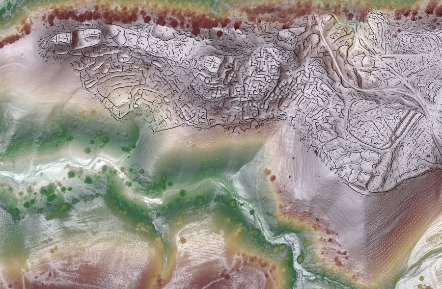
Credit: SAIElab/J.Berner/M.Frachetti

LiDAR-equipped drones have helped archaeologists make a ground-breaking discovery—two ancient cities on the Silk Road, an ancient network of trade routes that connected China to the Mediterranean. The finding challenges the notion that mountains were barriers to Silk Road trade, showing they actually hosted major centers for interaction. These medieval cities, Tashbulak and Tugunbulak, are among the largest ever documented in the mountainous regions of the Silk Road, located at elevations of 1.2 and 1.4 miles above sea level (about the same elevation as Machu Picchu). The drone’s LiDAR scans provided detailed views of plazas, fortifications, roads, and habitations, revealing the urban structure of these highland communities from the 6th to 11th centuries. The high-resolution LiDAR images, made from multiple drone flights, are some of the most detailed ever published for archaeological sites.

LEARN MORE


Make sure to sign up for our free weekly newsletter using the button below so you can get our weekly newsletter every Saturday, with this roundup and our other featured stories from the week.

Join a global community of

100,000+

drone enthusiasts.

Subscribe

Drone Pilot's Guide to DJI Mini 4 Pro

  • Navigate the DJI Fly app and flight modes with ease
  • Adjust camera and safety settings for better control
  • Understand intelligent flight features and how to use them
  • Avoid common beginner mistakes
  • Get the most out of your drone—without the guesswork

Drone Pilot's Guide to DJI Air 3S

  • Navigate the DJI Fly app and flight modes with ease
  • Adjust camera and safety settings for better control
  • Understand intelligent flight features and how to use them
  • Avoid common beginner mistakes
  • Get the most out of your drone—without the guesswork

Hands-On Flight Training

$295

400+ 5-Star Reviews

  • Team up with a knowledgeable, friendly instructor at a convenient outdoor spot — like a park or athletic field
  • Fly a top-rated drone provided for you, or bring your own to get personalized guidance
  • Spend most of your time in the air with hands-on practice — learning about composition, camera angles and cinematic motion
  • Explore the DJI Fly app and learn how to use camera settings like ISO, shutter speed and aperture
  • Unlock the power of Intelligent Flight Modes to fly smoother, smarter, and with less stress
  • Get access to our Aerial Photo & Video online course with additional exercises and pro-level editing workflows – using Snapseed, Photopea, Adobe Lightroom, DJI LightCut, and Premiere Pro

Aerial Photo & Video for Drone Pilots

$179

3,500+ 5-Star Reviews

  • How to dial in the right camera settings like ISO, shutter speed, and aperture
  • The best angles & altitudes for different types of shots (real estate, landscapes, cityscapes, and more)
  • The secret to cinematic drone motion that makes your footage feel like a Hollywood movie
  • How to enhance colors, remove distractions, and sharpen details – even in tricky lighting
  • Pro-level editing workflows – whether you’re using Lightroom, free tools, or mobile apps

The Recreational UAS Safety Test

Free

150+ 5-Star Reviews

  • Required for U.S. recreational flyers of drones
  • Launched June 2021 by the FAA
  • Takes about 30 minutes to complete
  • No prior drone knowledge needed
  • Test allows unlimited attempts to pass

Drone Mapping Essentials Workshop

$799

3,500+ 5-Star Reviews

  • Expert instruction from expert drone pilots with over 100 hours of flying experience
  • Hands-on training of live data capture and how to process deliverables for your clients
  • Peer-to-peer networking with other professional drone pilots in the mapping industry
  • Free access to the online course, Drone Mapping Essentials

Flight Skills for Drone Pilots

$99

75+ 5-Star Reviews

  • 16 engaging video lectures with key takeaways
  • Action items with concrete steps so you put into practice what you learn
  • Pre-flight checklists to help you plan your flights
  • Resource links to websites, products and software for further learning and discovery

Drone Business & Mapping Bundle

$617 $397

3,500+ 5-Star Reviews

  • Drone Pilot Ground School
    1. 1:1 support with a Part 107 exam success coach
    2. Study 100% online at your own pace
    3. Unlimited practice exams with 400+ real FAA test questions
  • Drone Mapping Essentials
    1. 100+ instructional videos focused on real-world application with high-quality videos
    2. Downloadable resources like data capture checklists to utilize in your missions
    3. Monthly live instruction with course instructor, Dylan Gorman, to go deeper on topics where you need more clarification
  • The Drone Business Blueprint
    1. Expert instruction from industry veteran, Eno Umoh, who brings real-world experience in building successful drone businesses.
    2. 14 Comprehensive modules covering everything from business setup to marketing strategies
    3. 30 Downloadable resources to apply your learning immediately

Hands-On Flight Training

$295

400+ 5-Star Reviews

  • 45-60 minutes of hands-on flying time to master orientation and flight maneuvers tailored to your skill level
  • Learn how to handle obstacles such as lost GPS, low battery charge or emergencies
  • Practice flying under various intelligent flight modes
  • Ask questions about regulations, software, flight operations management, and more

The Drone Business Blueprint

$119

3,500+ 5-Star Reviews

  • Expert instruction from industry veteran, Eno Umoh, who brings real-world experience in building successful drone businesses.
  • 14 Comprehensive modules covering everything from business setup to marketing strategies
  • 30 Downloadable resources to apply your learning immediately
  • AI tools and techniques to boost productivity and streamline your operations

Commercial Drone Business Bundle

$418 $334

4,000+ 5-Star Reviews

  • Drone Pilot Ground School
    1. 1:1 support with a Part 107 exam success coach
    2. Study 100% online at your own pace
    3. Unlimited practice exams with 400+ real FAA test questions
  • The Drone Business Blueprint
    1. Expert instruction from industry veteran, Eno Umoh, who brings real-world experience in building successful drone businesses.
    2. 14 Comprehensive modules covering everything from business setup to marketing strategies
    3. 30 Downloadable resources to apply your learning immediately

Drone Mapping Essentials

$199

3,500+ 5-Star Reviews

  • 100+ instructional videos focused on real-world application with high-quality videos
  • Downloadable resources like data capture checklists to utilize in your missions
  • Quizzes to test your knowledge so you can succeed in the field
  • Monthly live instruction with course instructor, Dylan Gorman, to go deeper on topics where you need more clarification

Drone Pilot Pro Bundle

$713 $499

3,500+ 5-Star Reviews

  • Drone Pilot Ground School
    1. 1:1 support with a Part 107 exam success coach
    2. Study 100% online at your own pace
    3. Unlimited practice exams with 400+ real FAA test questions
  • Drone Pilot Skill Builder
    1. 16 engaging video lectures with key takeaways
    2. Action items with concrete steps so you put into practice what you learn
  • Hands-On Flight Training
    1. 45-60 minutes of hands-on flying time to master orientation and flight maneuvers tailored to your skill level

Drone Pilot Ground School

$299

4,000+ 5-Star Reviews

  • 1:1 support with a Part 107 exam success coach
  • Study 100% online at your own pace
  • Unlimited practice exams with 400+ real FAA test questions
  • Personalized study plans, virtual flashcards, and 12-page cram sheet
  • Weekly webinars on acing the Part 107 exam and monthly webinars to elevate your journey post-certification