Drone News Roundup: DJI Launches the Avata 2, Drone Follows Cliff Diver from Air into Water, and More!

BY Zacc Dukowitz
11 April 2024

This week we’re covering the much-awaited launch of the DJI Avata 2.

We’re also covering a video in which a drone follows a cliff diver through the air and into the water, the NYPD’s use of drones to inspect infrastructure after the recent earthquake that hit New York City, 150 people arrested in a prison smuggling scheme that relied heavily on drones, and Ohio’s launch of the first ever state-wide UTM for drone operations.

Now on to the links!

DJI Launches the Avata 2 and Goggles 3


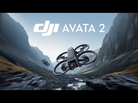
After several leaks revealed most of its specs DJI has finally released the Avata 2, the sequel to its popular cinewhoop drone. Along with the Avata 2, DJI has launched the Goggles 3, the newest version of its FPV goggles. The two come in a Fly More Combo that sells for just $999—a big drop in price from the $1,388 the original cost. (The drone itself sells for $489, also cheaper than the $629 the first Avata costs.) Standout upgrades on the Avata 2 include:

  • Larger camera sensor. The Avata 2 has a 1/1.3″ sensor compared to the 1.17″ sensor on the original.
  • Longer battery life. The Avata 2 has 23 minutes of battery life, which is four more than its predecessor.
  • Longer range. The Avata 2 has 1.86 miles (3 km) more range than the Avata did.
  • Greater range of gimbal tilt. The Avata 2 has five more degrees of gimbal tilt than the original.
  • Lighter, more stable airframe. The Avata 2 weighs 28 grams less than the Avata, and has an improved airframe that provides greater stability in flight.

LEARN MORE


Drone Follows Cliff Diver from Air into Water

This Drone Is A Professional Cliff Diver 🤿

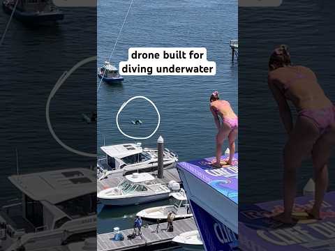
In this short clip from Red Bull we see a drone follow a cliff diver through the air, diving briefly into the water as she goes beneath the surface. We’ve seen shots of other drones that can both fly and go underwater, but this one caught our eye for its practical use. Here, the drone’s ability to go underwater lets the pilot follow the dive all the way through instead of having to worry about pulling up early to avoid getting the drone wet. Red Bull has been pushing the limits of how drones can be used to shoot extreme sports for a while now, and from what we can tell these shots were practice runs. We can’t wait to see the extreme sports shots Red Bull puts out next using this up-close approach.

LEARN MORE


NYPD Uses Drones to Inspect Infrastructure after 4.8 Earthquake

NYPD harbor patrol checking bridges, after 4.8-magnitude earthquake

Last week an earthquake hit New York City, measuring 4.8 on the Richter scale—not enough to cause buildings to collapse, but enough to make people worry about long-term damage to bridges and other structures. The NYPD is using the Skydio X10 and other drones to assess the impact the earthquake may have had on city infrastructure. According to NYPD Deputy Commissioner Kaz Daughtry, “We are scanning the bridges up and down, looking for any type of anomalies, looking for any structural defects, looking for anything that’s out of the ordinary.” Personnel from both NYPD and the NYC’s Department of Buildings are looking closely at drone footage to identify any issues, and using AI-powered software to identify potential problems as well.

LEARN MORE


150 Arrested in Drone Smuggling Prison Scheme

drones-smuggling-georgia

Authorities in Georgia recently arrested 150 people who were operating what’s believed to be the largest smuggling operation ever in the state’s prison system. The smuggling scheme relied on drones to carry contraband like drugs, tobacco, cellphones, and weapons into prisons. Eight prison employees were included in the operation, as well as the owner of a local drone repair shop called Thunder Drones. Called Operation Skyhawk, the investigation that led to the mass arrests took place over 16 months, revealing a large, sophisticated, and drone-supported smuggling ring. Over 1,000 criminal charges have been filed related to the arrests.

LEARN MORE


Ohio Launches First State-Wide UTM for Drone Operations

utm-ohio
Credit: CAL Analytics

The Ohio Department of Transportation (ODOT) has launched the first ever state-wide low-altitude air traffic management system, or UTM, for drone ops. UTM stands for Uncrewed Traffic Management, a phrase that refers to managing the airspace when multiple drone and crewed operations are happening at once. Much has been made of UTM over the last decade. NASA led a UTM project from 2015-2019, which included several tests of complicated flight scenarios over four phases of technical capability. The FAA has continued the effort, conducting ongoing tests at seven designated test sites to work toward a UTM framework that could be adopted nation-wide.

And states like North Dakota and New York, where two of these test sites are located, have invested heavily in building out drone infrastructure to support UTMs. North Dakota has a state-wide network for drone flights called Vantis made to support BVLOS flights, and New York has established a 50-mile drone corridor between Rome and Syracuse to test and deploy UTM technologies. Ohio’s state-wide UTM launch is a first to be celebrated, and hopefully a sign that more of these systems will be coming soon to other states throughout the country.

LEARN MORE


Make sure to sign up for our free weekly newsletter using the button below so you can get our weekly newsletter every Saturday, with this roundup and our other featured stories from the week.

Join a global community of

100,000+

drone enthusiasts.

Subscribe

Drone Pilot's Guide to DJI Mini 4 Pro

  • Navigate the DJI Fly app and flight modes with ease
  • Adjust camera and safety settings for better control
  • Understand intelligent flight features and how to use them
  • Avoid common beginner mistakes
  • Get the most out of your drone—without the guesswork

Drone Pilot's Guide to DJI Air 3S

  • Navigate the DJI Fly app and flight modes with ease
  • Adjust camera and safety settings for better control
  • Understand intelligent flight features and how to use them
  • Avoid common beginner mistakes
  • Get the most out of your drone—without the guesswork

Hands-On Flight Training

$295

400+ 5-Star Reviews

  • Team up with a knowledgeable, friendly instructor at a convenient outdoor spot — like a park or athletic field
  • Fly a top-rated drone provided for you, or bring your own to get personalized guidance
  • Spend most of your time in the air with hands-on practice — learning about composition, camera angles and cinematic motion
  • Explore the DJI Fly app and learn how to use camera settings like ISO, shutter speed and aperture
  • Unlock the power of Intelligent Flight Modes to fly smoother, smarter, and with less stress
  • Get access to our Aerial Photo & Video online course with additional exercises and pro-level editing workflows – using Snapseed, Photopea, Adobe Lightroom, DJI LightCut, and Premiere Pro

Aerial Photo & Video for Drone Pilots

$179

3,500+ 5-Star Reviews

  • How to dial in the right camera settings like ISO, shutter speed, and aperture
  • The best angles & altitudes for different types of shots (real estate, landscapes, cityscapes, and more)
  • The secret to cinematic drone motion that makes your footage feel like a Hollywood movie
  • How to enhance colors, remove distractions, and sharpen details – even in tricky lighting
  • Pro-level editing workflows – whether you’re using Lightroom, free tools, or mobile apps

The Recreational UAS Safety Test

Free

150+ 5-Star Reviews

  • Required for U.S. recreational flyers of drones
  • Launched June 2021 by the FAA
  • Takes about 30 minutes to complete
  • No prior drone knowledge needed
  • Test allows unlimited attempts to pass

Drone Mapping Essentials Workshop

$799

3,500+ 5-Star Reviews

  • Expert instruction from expert drone pilots with over 100 hours of flying experience
  • Hands-on training of live data capture and how to process deliverables for your clients
  • Peer-to-peer networking with other professional drone pilots in the mapping industry
  • Free access to the online course, Drone Mapping Essentials

Flight Skills for Drone Pilots

$99

75+ 5-Star Reviews

  • 16 engaging video lectures with key takeaways
  • Action items with concrete steps so you put into practice what you learn
  • Pre-flight checklists to help you plan your flights
  • Resource links to websites, products and software for further learning and discovery

Drone Business & Mapping Bundle

$617 $397

3,500+ 5-Star Reviews

  • Drone Pilot Ground School
    1. 1:1 support with a Part 107 exam success coach
    2. Study 100% online at your own pace
    3. Unlimited practice exams with 400+ real FAA test questions
  • Drone Mapping Essentials
    1. 100+ instructional videos focused on real-world application with high-quality videos
    2. Downloadable resources like data capture checklists to utilize in your missions
    3. Monthly live instruction with course instructor, Dylan Gorman, to go deeper on topics where you need more clarification
  • The Drone Business Blueprint
    1. Expert instruction from industry veteran, Eno Umoh, who brings real-world experience in building successful drone businesses.
    2. 14 Comprehensive modules covering everything from business setup to marketing strategies
    3. 30 Downloadable resources to apply your learning immediately

Hands-On Flight Training

$295

400+ 5-Star Reviews

  • 45-60 minutes of hands-on flying time to master orientation and flight maneuvers tailored to your skill level
  • Learn how to handle obstacles such as lost GPS, low battery charge or emergencies
  • Practice flying under various intelligent flight modes
  • Ask questions about regulations, software, flight operations management, and more

The Drone Business Blueprint

$119

3,500+ 5-Star Reviews

  • Expert instruction from industry veteran, Eno Umoh, who brings real-world experience in building successful drone businesses.
  • 14 Comprehensive modules covering everything from business setup to marketing strategies
  • 30 Downloadable resources to apply your learning immediately
  • AI tools and techniques to boost productivity and streamline your operations

Commercial Drone Business Bundle

$418 $334

4,000+ 5-Star Reviews

  • Drone Pilot Ground School
    1. 1:1 support with a Part 107 exam success coach
    2. Study 100% online at your own pace
    3. Unlimited practice exams with 400+ real FAA test questions
  • The Drone Business Blueprint
    1. Expert instruction from industry veteran, Eno Umoh, who brings real-world experience in building successful drone businesses.
    2. 14 Comprehensive modules covering everything from business setup to marketing strategies
    3. 30 Downloadable resources to apply your learning immediately

Drone Mapping Essentials

$199

3,500+ 5-Star Reviews

  • 100+ instructional videos focused on real-world application with high-quality videos
  • Downloadable resources like data capture checklists to utilize in your missions
  • Quizzes to test your knowledge so you can succeed in the field
  • Monthly live instruction with course instructor, Dylan Gorman, to go deeper on topics where you need more clarification

Drone Pilot Pro Bundle

$713 $499

3,500+ 5-Star Reviews

  • Drone Pilot Ground School
    1. 1:1 support with a Part 107 exam success coach
    2. Study 100% online at your own pace
    3. Unlimited practice exams with 400+ real FAA test questions
  • Drone Pilot Skill Builder
    1. 16 engaging video lectures with key takeaways
    2. Action items with concrete steps so you put into practice what you learn
  • Hands-On Flight Training
    1. 45-60 minutes of hands-on flying time to master orientation and flight maneuvers tailored to your skill level

Drone Pilot Ground School

$299

4,000+ 5-Star Reviews

  • 1:1 support with a Part 107 exam success coach
  • Study 100% online at your own pace
  • Unlimited practice exams with 400+ real FAA test questions
  • Personalized study plans, virtual flashcards, and 12-page cram sheet
  • Weekly webinars on acing the Part 107 exam and monthly webinars to elevate your journey post-certification