

Drone News Roundup: Budapest by FPV Drone, AirData’s Plan to Back Up Your DJI Drone Data, and More!
BY Zacc Dukowitz
3 October 2024This week we’re covering a beautiful, cinematic drone tour of Budapest shot by Josh Turner.
We’re also covering AirData’s partnership with Google to help drone pilots back up their DJI drone data, Teledyne’s new LiDAR drone sensor, Skydio’s software made just for first responders, and key insights shared by DJI’s global head of policy on a recent Reddit AMA.
Now let’s get to those links!
Budapest by FPV Drone

This FPV drone tour of Budapest was shot on an FPV drone by YouTuber Josh Turner. Turner has been making a name for himself with aerial tours like this, traveling around the world to far flung places like Iceland, Uganda, and Shanghai. (Check out this FPV dive he shot down the tallest skyscraper in Shanghai.) Budapest is the capital of Hungary, and serves as the country’s political, cultural, and economic center. The city has several UNESCO World Heritage sites and Turner captures many of them here, including the Hungarian Parliament Building, the Matthias Church and Fisherman’s Bastion, and Heroes’ Square. According to Turner, all the footage in the video was shot on a cinewhoop and a 3″, sub-.55 pound FPV drone.
LEARN MORE
AirData’s Plan to Back Up Your DJI Drone Data
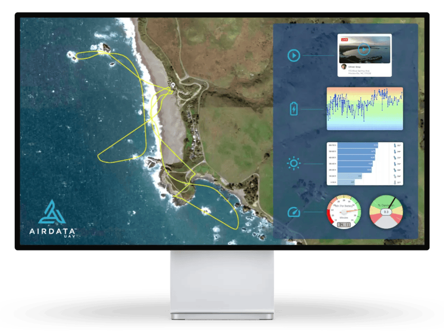
Credit: AirData
Any DJI flight data you might currently have saved will soon go away. In mid-October, DJI will end access to saved flight data on the DJI Fly app, and on November 7 it will end access to flight data on the DJI Pilot app. To fill the gap, drone fleet management platform AirData has partnered with Google to deliver flight syncing for DJI drones. The only catch is that you have to use an Android device. AirData will offer automated flight syncing on both Android tablets and smartphones for several apps, including DJI Fly, DJI GO 4, and DJI Pilot. It will also offer syncing for non-DJI apps, including Autel Explorer, Autel Enterprise, Pix4D, and DroneSense.
LEARN MORE
Teledyne Launches the EchoOne, a New LiDAR Solution for Drones

Credit: Teledyne
Teledyne has launched a new LiDAR drone sensor called the EchoOne. Made in partnership with Inertial Labs (IL), the EchoOne combines Teledyne’s LiDAR and camera technology with IMU and INS technology from IL. Though pricing isn’t public, Teledyne describes the EchoOne as affordable, indicating that it’s within the price range of professionals who may be looking for an aerial LiDAR solution but are priced out by existing options.
Here are the key features of the EchoOne:
- Long-range and lightweight. EchoONE weighs just 2.6 pounds (1.2 kg) and can be operated from UAVs such as the Freefly Astro, Inspired Flight IF800, and DJI M300/M350, while collecting engineer-grade data reliably at a regulatory limit of 400 feet agl (120 meters).
- Accuracy and speed. Full undecimated georeferenced point clouds generated in real-time allowing infield verification combined with rapid post-processing through RESEPI’s “one-click” PC-Master Pro post-processing solution.
- Range precision and accuracy. 2 cm range precision (1 sigma) and 5 cm range accuracy (1 sigma).
LEARN MORE
Skydio Launches First Responder Software DFR Command

Credit: Skydio
Skydio has launched a new software for first responders. Called DFR Command, the platform is designed to help police departments and other public safety agencies use the data captured by drones deployed to the scenes of emergencies in DFR (Drone as First Responder) programs. According to Skydio, DFR Command shares this drone data with officers to help keep them “informed, steps ahead, and aware of reality on the ground from one objective source of truth.”
Key features for DFR Command include:
- Rapid deployment. Drones can be airborne in just 20 seconds from pre-positioned Skydio Docks, enabling quick response times.
- Multi-drone operation. Allows a single pilot to control multiple drones simultaneously, enhancing situational awareness and coverage.
- Advanced flight planning. Skydio Pathfinder optimizes flight paths while integrating with airspace awareness systems for safe navigation.
- Real-time video sharing. Livestream capabilities enable sharing video feeds with various platforms, enhancing communication during incidents.
- Automated evidence management. Facilitates seamless upload of flight data and video evidence to systems like Axon Evidence for efficient incident documentation.
LEARN MORE
Key Findings from Reddit AMA with DJI’s Global Head of Policy
Credit: DJI
DJI’s Global Head of Policy did an AMA (Ask Me Anything) on Reddit not too long ago, answering questions people had about DJI’s data privacy practices and what might happen if the DJI ban gets passed. In his answers, Welsh emphasized that DJI was committed to the U.S. market and didn’t plan to leave it any time soon.
Here are the key findings from Welsh’s answers on the AMA:
- Commitment to the US Market. Welsh firmly stated that DJI has no plans to abandon the U.S. market, despite growing tensions and potential legislative challenges.
- Potential US manufacturing. One of the most interesting topics discussed was the possibility of DJI establishing U.S.-based manufacturing to address data security concerns and Chinese ownership issues. Welsh revealed that the company has explored setting up manufacturing lines and servers in the U.S. However, he cautioned that this would significantly increase costs for customers without necessarily guaranteeing a permanent solution to regulatory concerns.
- Data security concerns. Welsh firmly rebutted concerns about DJI drones potentially relaying information to the Chinese government. He stated that U.S. customer data is stored exclusively on U.S.-based servers and that DJI has never received requests for data under China’s National Intelligence Law.
- Legislative challenges. Welsh addressed the potential impact of legislation like the Countering CCP Drones Act1. If passed, the law would add DJI to the FCC’s Covered List, preventing the company from obtaining necessary certifications for new products. While it may not immediately affect current drone fleets, there’s a possibility of retroactive restrictions on DJI drone usage, even for those already purchased.
LEARN MORE
Make sure to sign up for our free weekly newsletter using the button below so you can get our weekly newsletter every Saturday, with this roundup and our other featured stories from the week.


