3D Mapping Alcatraz: How Drones Helped Make the Most Detailed 3D Map of the Island Ever

BY Zacc Dukowitz
25 November 2025

Using three professional drones and a Spot robot dog, a volunteer team has created the most detailed 3D map of Alcatraz ever made.

A drone and a robot dog revealed lost secrets of Alcatraz

The project took a grueling three weeks on-site to pull off, with teams collecting data all across the island’s 22.5 acres.

The result isn’t just a cool virtual model of one of America’s most infamous prisons. It’s a massive, science-grade dataset that can help the Park Service monitor erosion, spot structural issues, and preserve Alcatraz as rising seas and over a million visitors a year slowly wear it down.

Turn an Island Prison into a Digital Twin

The Alcatraz project was led by reality capture specialist Pete Kelsey and his company VCTO Labs.

To pull off this huge 3D mapping project, Kelsey and his team moved onto the island for three weeks, building a full-blown reality-capture lab inside the former prison.

alcatraz-elios-3
Geoff Helloin of UAS Inc. preps the Elios 3 | Credit: Flyability / UAS Inc.

Working with the National Park Service, VCTO Labs assembled more than 20 volunteers from around the world—surveyors, drone pilots, laser-scanning pros, and software experts—and gave each of them a piece of the island to digitize, from the parade grounds and lighthouse to buried cisterns and sealed-off dungeons.

The hardware used included three drones:

  • Flyability’s Elios 3 indoor drone for collecting LiDAR and visual data in confined spaces.
  • eBee X fixed-wing mapping drone for high-resolution RGB and multispectral photogrammetry over the entire island.
  • Inspired Flight’s IF1200 multirotor with a Phoenix LiDAR RANGER-U120 scanner for high-precision aerial LiDAR around cliffs, walls, and structures.

The project also relied on other robots and data collection tools:

  • Boston Dynamics’ Spot robot fitted with an Emesent Hovermap LiDAR system for scanning hazardous interior areas with lead and asbestos risk.
  • RIEGL terrestrial laser scanners for long-range exterior and corridor scans tied into the survey control network.
  • Survey control equipment (GNSS receivers and total stations) to establish a precise control network across the island.
  • High-performance AMD-powered workstation on site for processing and merging the 3–4 TB of collected data into the Alcatraz digital twin.

How the Data Was Collected and Processed

To start, Kelsey’s team locked in survey control so all the data layers would line up within a few millimeters.

The team could only fly drones around dawn, since tourists were there during the day and seabirds were nesting at night, making it challenging, time-sensitive work.

alcatraz-3d-map-drone

Once the data was captured—about 3–4 terabytes by the end—it was processed on site using an AMD-powered Lenovo workstation and stitched into a single, ultra-detailed digital twin that the Park Service can use as a baseline for decades.

Here’s how each tool contributed to capturing Alcatraz as a digital twin:

  • Outside the prison. An eBee X fixed-wing mapping drone flew survey-grade photogrammetry and multispectral missions over the entire 22-acre island, capturing RGB and multispectral data in a single flight for the topography, vegetation, and shorelines.
  • Heavy-lift LiDAR runs. An IF1200 multirotor carried a Phoenix LiDAR RANGER-U120 scanner to get high-precision LiDAR around cliffs, walls, towers, and deteriorating concrete structures.
  • Confined-space work with Elios 3. Flyability’s Elios 3 went into places no person could safely go—inside the powerhouse, up the smokestack, into a sealed Civil War-era dungeon, and down into buried cisterns—collecting LiDAR and video in spaces as tight as 50×50 cm.
  • Robots for hazardous areas. A Boston Dynamics Spot robot fitted with Emesent’s Hovermap LiDAR handled rooms with lead and asbestos risk, keeping people out while still feeding the model with dense interior scans.
  • Ground-based laser scans. RIEGL terrestrial laser scanners filled in long-range exteriors and interior corridors, tying everything back to the control network so aerial, indoor, and robotic data all snapped together.
  • Reality-capture software stack. ESRI’s ArcGIS Reality and Epic Games tools (RealityScan, Twinmotion, Unreal Engine) fused LiDAR, photos, and multispectral data into a single, explorable model—Alcatraz as a navigable digital twin instead of a flat map.

The result of all this work is a layered dataset where every brick, tunnel, and rusting beam on Alcatraz is anchored to survey-grade coordinates and can be revisited, measured, and compared over time.

alcatraz-lidar-video-flyability

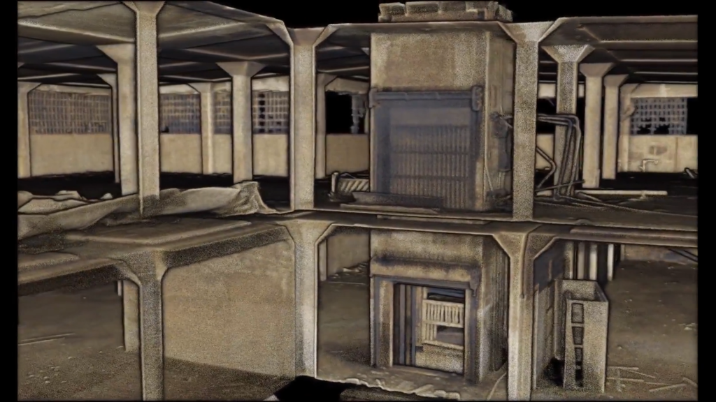
An image made with LiDAR data from the Elios 3

Why Projects Like This Matter

By turning the island of Alcatraz into a digital twin, Kelsey’s team gave the National Park Service a high-precision “before” picture they can return to again and again.

Every wall, tunnel, and shoreline is locked to survey-grade coordinates, so rangers and engineers can measure exactly how Alcatraz changes over the coming decades instead of relying on old photos and gut checks.

This matters, because every year the island, which is a National Historic Landmark, is beset by rising water, with storms, earthquakes, and more than a million visitors all slowly wearing it down.

By capturing the details of the island in 3D, the team helps the Park Service:

  • Preserve a layered history. Alcatraz has been a Civil War fort, a federal prison, a Native American occupation site, and now a seabird sanctuary. A detailed 3D record helps protect all of those stories, not just the prison era.
  • See risks before they become a disaster. With a full 3D baseline, the Park Service can spot erosion, cracking concrete, and shifting structures early, then prioritize repairs before problems become unsafe or irreversible.
  • Reduce exposure in dangerous spaces. Drones and robots can re-scan hazardous areas—places with lead, asbestos, or unstable ceilings—without sending people back into harm’s way every time someone needs new measurements.
  • Expand access without extra wear and tear. A high-fidelity digital twin lets people “visit” sealed-off dungeons, cisterns, and tunnels virtually, opening new educational and tourism experiences without adding more foot traffic to fragile structures.

The workflow behind this project points toward the future of drone mapping: multimodal capture, dense digital twins, and conservation decisions driven by hard data instead of guesses.

As more sites adopt this approach—from bridges and mines to historic landmarks—the line between the physical world and its digital record will keep getting thinner. And that’s good news for anyone trying to keep important places in our history intact a little longer.

Join a global community of

100,000+

drone enthusiasts.

Subscribe

Drone Pilot's Guide to DJI Mini 4 Pro

  • Navigate the DJI Fly app and flight modes with ease
  • Adjust camera and safety settings for better control
  • Understand intelligent flight features and how to use them
  • Avoid common beginner mistakes
  • Get the most out of your drone—without the guesswork

Drone Pilot's Guide to DJI Air 3S

  • Navigate the DJI Fly app and flight modes with ease
  • Adjust camera and safety settings for better control
  • Understand intelligent flight features and how to use them
  • Avoid common beginner mistakes
  • Get the most out of your drone—without the guesswork

Hands-On Flight Training

$295

400+ 5-Star Reviews

  • Team up with a knowledgeable, friendly instructor at a convenient outdoor spot — like a park or athletic field
  • Fly a top-rated drone provided for you, or bring your own to get personalized guidance
  • Spend most of your time in the air with hands-on practice — learning about composition, camera angles and cinematic motion
  • Explore the DJI Fly app and learn how to use camera settings like ISO, shutter speed and aperture
  • Unlock the power of Intelligent Flight Modes to fly smoother, smarter, and with less stress
  • Get access to our Aerial Photo & Video online course with additional exercises and pro-level editing workflows – using Snapseed, Photopea, Adobe Lightroom, DJI LightCut, and Premiere Pro

Aerial Photo & Video for Drone Pilots

$179

3,500+ 5-Star Reviews

  • How to dial in the right camera settings like ISO, shutter speed, and aperture
  • The best angles & altitudes for different types of shots (real estate, landscapes, cityscapes, and more)
  • The secret to cinematic drone motion that makes your footage feel like a Hollywood movie
  • How to enhance colors, remove distractions, and sharpen details – even in tricky lighting
  • Pro-level editing workflows – whether you’re using Lightroom, free tools, or mobile apps

Drone Mapping Essentials Workshop

$799

3,500+ 5-Star Reviews

  • Expert instruction from expert drone pilots with over 100 hours of flying experience
  • Hands-on training of live data capture and how to process deliverables for your clients
  • Peer-to-peer networking with other professional drone pilots in the mapping industry
  • Free access to the online course, Drone Mapping Essentials

The Recreational UAS Safety Test

Free

150+ 5-Star Reviews

  • Required for U.S. recreational flyers of drones
  • Launched June 2021 by the FAA
  • Takes about 30 minutes to complete
  • No prior drone knowledge needed
  • Test allows unlimited attempts to pass

Drone Business & Mapping Bundle

$617 $397

3,500+ 5-Star Reviews

  • Drone Pilot Ground School
    1. 1:1 support with a Part 107 exam success coach
    2. Study 100% online at your own pace
    3. Unlimited practice exams with 400+ real FAA test questions
  • Drone Mapping Essentials
    1. 100+ instructional videos focused on real-world application with high-quality videos
    2. Downloadable resources like data capture checklists to utilize in your missions
    3. Monthly live instruction with course instructor, Dylan Gorman, to go deeper on topics where you need more clarification
  • The Drone Business Blueprint
    1. Expert instruction from industry veteran, Eno Umoh, who brings real-world experience in building successful drone businesses.
    2. 14 Comprehensive modules covering everything from business setup to marketing strategies
    3. 30 Downloadable resources to apply your learning immediately

Hands-On Flight Training

$295

400+ 5-Star Reviews

  • 45-60 minutes of hands-on flying time to master orientation and flight maneuvers tailored to your skill level
  • Learn how to handle obstacles such as lost GPS, low battery charge or emergencies
  • Practice flying under various intelligent flight modes
  • Ask questions about regulations, software, flight operations management, and more

Flight Skills for Drone Pilots

$99

75+ 5-Star Reviews

  • 16 engaging video lectures with key takeaways
  • Action items with concrete steps so you put into practice what you learn
  • Pre-flight checklists to help you plan your flights
  • Resource links to websites, products and software for further learning and discovery

The Drone Business Blueprint

$119

3,500+ 5-Star Reviews

  • Expert instruction from industry veteran, Eno Umoh, who brings real-world experience in building successful drone businesses.
  • 14 Comprehensive modules covering everything from business setup to marketing strategies
  • 30 Downloadable resources to apply your learning immediately
  • AI tools and techniques to boost productivity and streamline your operations

Commercial Drone Business Bundle

$418 $334

4,000+ 5-Star Reviews

  • Drone Pilot Ground School
    1. 1:1 support with a Part 107 exam success coach
    2. Study 100% online at your own pace
    3. Unlimited practice exams with 400+ real FAA test questions
  • The Drone Business Blueprint
    1. Expert instruction from industry veteran, Eno Umoh, who brings real-world experience in building successful drone businesses.
    2. 14 Comprehensive modules covering everything from business setup to marketing strategies
    3. 30 Downloadable resources to apply your learning immediately

Drone Mapping Essentials

$199

3,500+ 5-Star Reviews

  • 100+ instructional videos focused on real-world application with high-quality videos
  • Downloadable resources like data capture checklists to utilize in your missions
  • Quizzes to test your knowledge so you can succeed in the field
  • Monthly live instruction with course instructor, Dylan Gorman, to go deeper on topics where you need more clarification

Drone Pilot Pro Bundle

$713 $499

3,500+ 5-Star Reviews

  • Drone Pilot Ground School
    1. 1:1 support with a Part 107 exam success coach
    2. Study 100% online at your own pace
    3. Unlimited practice exams with 400+ real FAA test questions
  • Drone Pilot Skill Builder
    1. 16 engaging video lectures with key takeaways
    2. Action items with concrete steps so you put into practice what you learn
  • Hands-On Flight Training
    1. 45-60 minutes of hands-on flying time to master orientation and flight maneuvers tailored to your skill level

Drone Pilot Ground School

$299

4,000+ 5-Star Reviews

  • 1:1 support with a Part 107 exam success coach
  • Study 100% online at your own pace
  • Unlimited practice exams with 400+ real FAA test questions
  • Personalized study plans, virtual flashcards, and 12-page cram sheet
  • Weekly webinars on acing the Part 107 exam and monthly webinars to elevate your journey post-certification