Drone Research Finds that Glaciers in the Pyrenees Mountains Are Disappearing as the Climate Warms

BY Zacc Dukowitz
14 October 2021

Climate change researchers from the Pyrenean Institute of Ecology recently issued a study that uses drone data to look at how much glaciers in the Pyrenees Mountains have melted over the last decade.

Using imagery and LiDAR data captured by drone and 3D models created from drone data, the researchers concluded that the glaciers are melting at a rapid pace, and might soon disappear—in fact, some smaller glaciers did disappear over the course of the study.

pyrenees-glacier
Image source

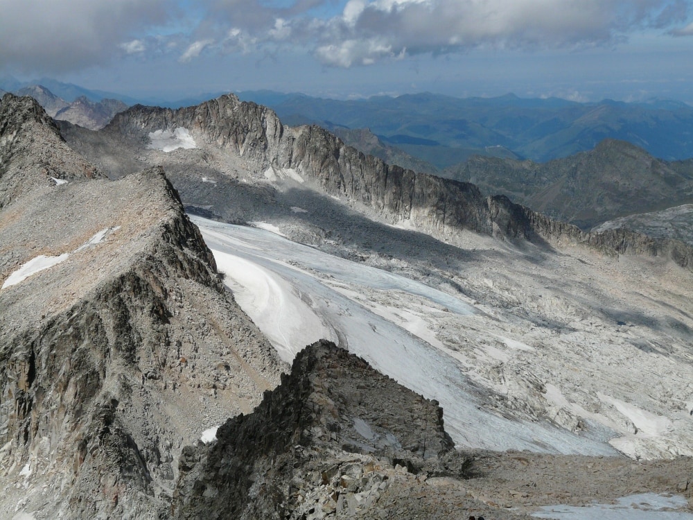
The Pyrenean glaciers found in the Pyrenees Mountains, which runs between Spain and France, are the biggest glaciers in southern Europe.

The conclusions from the study have serious implications about how fast other glaciers and ice masses throughout the world might also be melting due to the warming climate.

What we are seeing here is an advance warning of what may happen in other mountains, like in the Alps. Their glaciers have much more mass and entity, but we are showing them the way.

– Jesús Revuelto, Post-Doc at the National Center for Meteorological Research

How the Research Was Conducted

Researchers studied the glaciers on the Pyrenees Mountains from 2011 to 2020 using LiDAR data and visual data collected by drone, as well as using data from high-resolution optical satellites.

To conduct the study, researchers compared two datasets, both of which had been collected by drone.

[Related read: Drone Mapping Helps Indigenous People Impacted by Climate Change in Panama Find a New Home]

The first dataset was taken in 2011. In both October and November, the Spanish National Geographic Institute flew several data-collection missions over the Pyrenees Mountains, amassing LiDAR data about the glaciers there. Among climate scientists, LiDAR is known to produce high-resolution data for glacier surface elevation changes.

From the data collected in 2011, 24 glaciers were mapped in total. Researchers used this data to get measurements of the surface elevation of the glaciers in the Pyrenees, creating high resolution Digital Elevation Models (DEMs).

In 2020, researchers did a second round of data collection, flying several missions from August to October to collect LiDAR and visual data. The 2020 data was then processed with Pix4Dmapper to create dense 3D point clouds of the glaciers.

drones-glaciers-melting
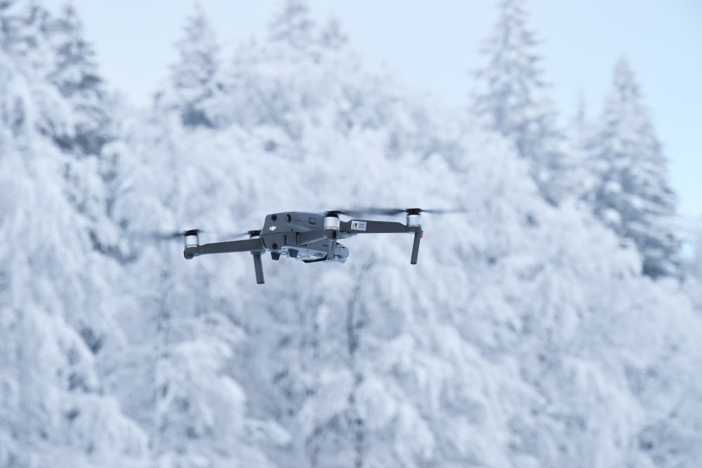
A DJI Mavic 2 Pro flying in the snow (Image source)

Here are the drones the researchers used for the 2020 mission:

  • A senseFly eBee-Plus fixed wing drone
  • A senseFly eBee-X fixed wing drone
  • A DJI Mavic 2 Pro quadcopter

The two fixed wing drones came with a senseFly S.O.D.A. digital camera, and had GPS receivers that supported RTK (Real Time Kinematic) or PPK (Post-Processed Kinematic) positioning systems, which allowed for positioning accuracy of about two inches.

Changes Observed to the Glaciers

When researchers compared the data taken in 2011 with that taken in 2020, they found that the 24 glaciers they’d been following had shrunk by an average of 23.2%, and that three of them had almost completely disappeared.

Overall, the thickness of the glaciers decreased by an average of 20 feet over the nine years of the study, shrinking at an average rate of about 2.6% per year. The areas where the glaciers had melted the most were concentrated at higher altitudes, at an elevation of between 1.7 miles and 1.85 miles.

glacier-study-drones
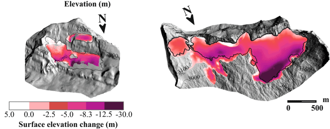
Comparison between the 2011 and 2020 glacier areas (the black line is the 2020 area)

The images above provide a quick way to visualize this loss—as you can see, the amount of mass the glaciers lost is significant.

Glacier shrinkage in the Pyrenees and wastage have not slowed down in the last few years . . . Pyrenean glaciers are in a clear imbalance with the regional climate, and will likely disappear in the next few decades.

Toward an Ice-Free Mountain Range: Demise of Pyrenean Glaciers During 2011–2020

Join a global community of

100,000+

drone enthusiasts.

Subscribe

Drone Pilot's Guide to DJI Mini 4 Pro

  • Navigate the DJI Fly app and flight modes with ease
  • Adjust camera and safety settings for better control
  • Understand intelligent flight features and how to use them
  • Avoid common beginner mistakes
  • Get the most out of your drone—without the guesswork

Drone Pilot's Guide to DJI Air 3S

  • Navigate the DJI Fly app and flight modes with ease
  • Adjust camera and safety settings for better control
  • Understand intelligent flight features and how to use them
  • Avoid common beginner mistakes
  • Get the most out of your drone—without the guesswork

Hands-On Flight Training

$295

400+ 5-Star Reviews

  • Team up with a knowledgeable, friendly instructor at a convenient outdoor spot — like a park or athletic field
  • Fly a top-rated drone provided for you, or bring your own to get personalized guidance
  • Spend most of your time in the air with hands-on practice — learning about composition, camera angles and cinematic motion
  • Explore the DJI Fly app and learn how to use camera settings like ISO, shutter speed and aperture
  • Unlock the power of Intelligent Flight Modes to fly smoother, smarter, and with less stress
  • Get access to our Aerial Photo & Video online course with additional exercises and pro-level editing workflows – using Snapseed, Photopea, Adobe Lightroom, DJI LightCut, and Premiere Pro

Aerial Photo & Video for Drone Pilots

$179

3,500+ 5-Star Reviews

  • How to dial in the right camera settings like ISO, shutter speed, and aperture
  • The best angles & altitudes for different types of shots (real estate, landscapes, cityscapes, and more)
  • The secret to cinematic drone motion that makes your footage feel like a Hollywood movie
  • How to enhance colors, remove distractions, and sharpen details – even in tricky lighting
  • Pro-level editing workflows – whether you’re using Lightroom, free tools, or mobile apps

The Recreational UAS Safety Test

Free

150+ 5-Star Reviews

  • Required for U.S. recreational flyers of drones
  • Launched June 2021 by the FAA
  • Takes about 30 minutes to complete
  • No prior drone knowledge needed
  • Test allows unlimited attempts to pass

Drone Mapping Essentials Workshop

$799

3,500+ 5-Star Reviews

  • Expert instruction from expert drone pilots with over 100 hours of flying experience
  • Hands-on training of live data capture and how to process deliverables for your clients
  • Peer-to-peer networking with other professional drone pilots in the mapping industry
  • Free access to the online course, Drone Mapping Essentials

Flight Skills for Drone Pilots

$99

75+ 5-Star Reviews

  • 16 engaging video lectures with key takeaways
  • Action items with concrete steps so you put into practice what you learn
  • Pre-flight checklists to help you plan your flights
  • Resource links to websites, products and software for further learning and discovery

Drone Business & Mapping Bundle

$617 $397

3,500+ 5-Star Reviews

  • Drone Pilot Ground School
    1. 1:1 support with a Part 107 exam success coach
    2. Study 100% online at your own pace
    3. Unlimited practice exams with 400+ real FAA test questions
  • Drone Mapping Essentials
    1. 100+ instructional videos focused on real-world application with high-quality videos
    2. Downloadable resources like data capture checklists to utilize in your missions
    3. Monthly live instruction with course instructor, Dylan Gorman, to go deeper on topics where you need more clarification
  • The Drone Business Blueprint
    1. Expert instruction from industry veteran, Eno Umoh, who brings real-world experience in building successful drone businesses.
    2. 14 Comprehensive modules covering everything from business setup to marketing strategies
    3. 30 Downloadable resources to apply your learning immediately

Hands-On Flight Training

$295

400+ 5-Star Reviews

  • 45-60 minutes of hands-on flying time to master orientation and flight maneuvers tailored to your skill level
  • Learn how to handle obstacles such as lost GPS, low battery charge or emergencies
  • Practice flying under various intelligent flight modes
  • Ask questions about regulations, software, flight operations management, and more

The Drone Business Blueprint

$119

3,500+ 5-Star Reviews

  • Expert instruction from industry veteran, Eno Umoh, who brings real-world experience in building successful drone businesses.
  • 14 Comprehensive modules covering everything from business setup to marketing strategies
  • 30 Downloadable resources to apply your learning immediately
  • AI tools and techniques to boost productivity and streamline your operations

Commercial Drone Business Bundle

$418 $334

4,000+ 5-Star Reviews

  • Drone Pilot Ground School
    1. 1:1 support with a Part 107 exam success coach
    2. Study 100% online at your own pace
    3. Unlimited practice exams with 400+ real FAA test questions
  • The Drone Business Blueprint
    1. Expert instruction from industry veteran, Eno Umoh, who brings real-world experience in building successful drone businesses.
    2. 14 Comprehensive modules covering everything from business setup to marketing strategies
    3. 30 Downloadable resources to apply your learning immediately

Drone Mapping Essentials

$199

3,500+ 5-Star Reviews

  • 100+ instructional videos focused on real-world application with high-quality videos
  • Downloadable resources like data capture checklists to utilize in your missions
  • Quizzes to test your knowledge so you can succeed in the field
  • Monthly live instruction with course instructor, Dylan Gorman, to go deeper on topics where you need more clarification

Drone Pilot Pro Bundle

$713 $499

3,500+ 5-Star Reviews

  • Drone Pilot Ground School
    1. 1:1 support with a Part 107 exam success coach
    2. Study 100% online at your own pace
    3. Unlimited practice exams with 400+ real FAA test questions
  • Drone Pilot Skill Builder
    1. 16 engaging video lectures with key takeaways
    2. Action items with concrete steps so you put into practice what you learn
  • Hands-On Flight Training
    1. 45-60 minutes of hands-on flying time to master orientation and flight maneuvers tailored to your skill level

Drone Pilot Ground School

$299

4,000+ 5-Star Reviews

  • 1:1 support with a Part 107 exam success coach
  • Study 100% online at your own pace
  • Unlimited practice exams with 400+ real FAA test questions
  • Personalized study plans, virtual flashcards, and 12-page cram sheet
  • Weekly webinars on acing the Part 107 exam and monthly webinars to elevate your journey post-certification