

DJI Launches Global Drone Rescue Map, A Living Record of Drone Rescues throughout the World
BY Zacc Dukowitz
2 July 2020It seems like more and more these days we’re hearing stories about drones helping to save lives.

Photo credit: DJI
Just last week a family lost while hiking on a nature preserve in Plant City, Florida was found quickly with the help of a drone. Highs that day were in the 90s, and the family could have faced heatstroke if they weren’t found in a timely manner.
And earlier this year, a similar story came out of Alaska, where the Anchorage Police Department used a drone to find a woman lost in snowy woods in just 15 minutes. Using a loudspeaker attached to the drone, police were able to reassure her that help was on the way, and she was rescued with no injuries.
Accounts like these seem to be cropping up more and more in the media—but has the use of drones to save lives increased, or has the media just grown more interested in these stories?
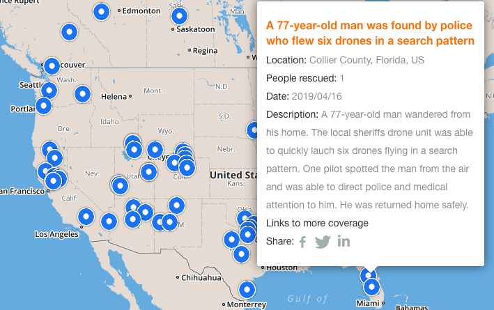
DJI’s Global Drone Rescue Map
If you’ve been wondering whether drone rescues have in fact been increasing, look no further than DJI’s new Global Drone Rescue Map.

Check out the interactive map here
The map shows locations throughout the world where drone rescues have taken place. In this context, a drone rescue refers to instances in which:
- Drones have found missing people
- Drones have brought supplies to trapped survivors
- Drones have peered through smoke and darkness to find unconscious victims
Here is a little more information from DJI regarding the information provided in the map and their criteria for selection:
The DJI Drone Rescue Map includes instances of drones finding people lost in forests, fields and mountains, often in darkness using thermal imaging cameras; dropping life preservers to people struggling in water; locating boaters stranded on remote waterways; and helping rescue people who were at risk of harming themselves. The map does not include incidents when a drone is simply used as part of a larger search process; instead, a drone must have directly located, assisted and/or rescued a person in peril.
The map is interactive, allowing you to click into each country to see the specific locations where drone rescues have taken place. For each rescue, DJI has provided key details of the event as well as links to third parties with more information on the rescue.
Check out the interactive map here
A notable detail about DJI’s research is that some of these rescues were not covered by the media, but rather were discovered in social media posts from public safety agencies (usually law enforcement) or other local authorities.
[Related reading: Drones in Search and Rescue—5 Stories Showcasing Ways Search and Rescue Uses Drones to Save Lives]
In many of the drone rescues included in DJI’s new map, the essential factor drones provided was speed. By speeding up the process for finding a person missing at night in dangerously cold weather, or a person injured after a car accident, drones are helping save lives.
Many of these rescues involve the use of drones equipped with thermal cameras to help locate missing people by searching for their heat signatures.
One man whose rescue story is included in the report shared that a search and rescue volunteer used a drone to find him when he was injured and near death in a local park.
. . . a drone saved my life. My family and I are eternally grateful that a total stranger was able to use his drone to find me. It’s comforting to know that drones are helping so many other people around the world too, and I hope the DJI Drone Rescue Map demonstrates just why drones are so important in emergencies.
– Jason Mabee, Maryland man whose life was saved by drone
So—Have Drone Rescues Gone Up?
Yes. In fact, they’ve gone up significantly over the last few years.
DJI reports that a total of 413 people have been saved by drone in 234 different incidents across 28 different countries.
Public safety workers already know how drones are revolutionizing their work, and now the rest of the world can see their amazing stories in one place. The DJI Drone Rescue Map honors the incredible rescues they’ve made, and will allow everyone to see how drones help save people in the future.
– Romeo Durscher, DJI Senior Director of Public Safety Integration
DJI first started reporting on lives saved by drone in 2017. Here are the outstanding statistics it has shared on drone rescues starting then and going up to the present day:
- January-April, 2017—59 people saved by drone in 18 incidents (covered in a report entitled “Lives Saved: A Survey of Drones in Action”)
- May, 2017-April, 2018—65 people saved by drone in 27 incidents (covered in a report entitled “More Lives Saved: A Survey of Drone Rescues Around the World”)
- October, 2019—279 people total reported saved by drone (statistic shared at DJI AirWorks 2019)
- June, 2020—413 people total reported saved by drone in 234 incidents (Global Drone Rescue Map)
Reviewing this data, we can see a steady climb in the total number of drone rescues over the last three-and-a-half years.
Starting in 2017, we see the total number of drone rescues go from 59 in the first five months of the year, to a total of 124 by mid-2018.
A year-and-a-half later, in October of 2019, the total has reached 279, more than double the count from the previous year-and-a-half.
And now, just eight months after Airworks announced 279 total drone rescues in October of 2019, the number has jumped another 134 rescues—compare that to the 124 rescues we saw from early 2017 to mid-2018, and we see that the number of drone rescues has more than doubled since DJI first started reporting on them.
[Related reading: 14 Inspiring Examples of Drones Doing Good around the Globe]
This new map from DJI is a living record, and will be continuously updated as new drone rescues are reported throughout the world. It will be interesting to see both the numbers of rescues and the different kinds of scenarios in which drones are being used for rescues continue to go up in the coming years.
Help Keep the Map Up-to-Date
Know of a drone rescue that isn’t included on DJI’s map? You can let them know by submitting the rescue information on this form.
Note: Submissions must include basic information, such as the date and location of the rescue, as well links to news stories or authoritative social media posts from the rescuers.
Excited about DJI’s drone rescue map? Share your thoughts on this thread in the UAV Coach community forum.


