

What Is CTAF? A Drone Pilot’s Guide to Common Traffic Advisory Frequency
BY Zacc Dukowitz
5 June 2026A CTAF (Common Traffic Advisory Frequency) is the radio frequency pilots use to announce position and intentions near airports without an active control tower.
- For drone pilots, CTAF is an important source of situational awareness. Understanding what CTAF means can help you better interpret airport activity and the operating environment around nearby airports.
- For crewed aircraft pilots, CTAF is an important tool for maintaining awareness of nearby traffic. At many non-towered airports, pilots use it to coordinate arrivals, departures, and pattern operations when no air traffic controller is directing traffic.
Most drone pilots won’t be transmitting on a CTAF frequency during normal operations.
But CTAF still matters.
You’ll encounter it on sectional charts, airport information resources, and Part 107 study materials.
And understanding what CTAF means can help you better evaluate airport activity, interpret aviation charts, and avoid common misconceptions about airspace and FAA authorization requirements.
In this guide, we’ll cover what CTAF is, how it’s different from UNICOM and MULTICOM, how it’s used, where you’ll find it on sectional charts, and what drone pilots should know about it.
Here’s what we cover:
- What Is CTAF?
- Why CTAF Matters for Drone Pilots
- How to Find CTAF on a Sectional Chart
- CTAF vs. UNICOM vs. MULTICOM
- How CTAF Is Used at Non-Towered Airports
- CTAF FAQs
What Is CTAF?
CTAF stands for Common Traffic Advisory Frequency.
At airports without an active control tower, pilots use a CTAF to announce their position and intentions to other aircraft in the area.
These radio calls help pilots build a shared understanding of nearby traffic and reduce the risk of conflicts during arrivals, departures, and pattern operations.
Although CTAF is primarily used by crewed aircraft pilots, it can provide useful context for drone pilots.
Seeing a CTAF listed near an airport is often an indication that aircraft are coordinating traffic without direct air traffic control involvement.
In many cases, the CTAF at an airport is also the airport’s UNICOM frequency.
At some airports, it may instead be a MULTICOM or even a tower frequency when the tower is closed—we’ll cover the difference between these three terms below.
CTAF vs CT: What’s the Difference?
CTAF and CT are not the same thing.
CTAF stands for Common Traffic Advisory Frequency—the frequency pilots use to coordinate traffic at airports without an active control tower.
On sectional charts, CT refers to the airport’s control tower frequency.
This distinction can be confusing because the CTAF and control tower frequency are sometimes the same frequency. At other airports, they may be different.
When reviewing airport information on a sectional chart, pay close attention to the chart symbols and frequency listings rather than assuming CTAF and CT always refer to the same thing.
Why CTAF Matters for Drone Pilots
Airport awareness is the biggest reason CTAF matters for flying a drone.
Many drone flights happen near small airports without operating control towers.
Though they’re typically smaller, these airports can still have significant aircraft activity, including training flights, agricultural aircraft, helicopters, banner towing operations, and general aviation traffic flying at relatively low altitudes.
So when you see a CTAF listed on a sectional chart, it’s a signal that pilots in the area may be coordinating traffic on that frequency instead of through an air traffic controller.
For drone pilots, this matters because:
- It helps you better understand how active a nearby airport may be.
- It improves your ability to read sectional charts and airspace resources correctly.
- It can help you identify areas where extra visual awareness is important.
- It appears in Part 107 training and test-prep material regularly.
CTAF Doesn’t Determine Airspace
Just as importantly, CTAF does not automatically mean controlled airspace or FAA authorization requirements.
Some non-towered airports sit in uncontrolled Class G airspace, while others may have controlled airspace nearby or overhead.
That’s where many newer drone pilots get confused. CTAF is about traffic coordination—not airspace classification.
What CTAF Doesn’t Mean for Drone Pilots
One of the biggest misconceptions around CTAF is assuming it automatically changes the legal requirements for a drone flight.
It doesn’t.
CTAF is a traffic coordination frequency. It is not an airspace classification system and it is not an FAA authorization system.
This is important because newer drone pilots sometimes see a CTAF listed near an airport and assume:
- The airspace must be controlled
- ATC authorization is automatically required
- They are expected to communicate on the frequency
In reality, those are separate issues.
A non-towered airport with a CTAF may sit entirely inside Class G airspace, where FAA authorization may not be required for many drone operations.
And other airports may have nearby controlled airspace that does require authorization through LAANC or another FAA process. But the CTAF itself doesn’t determine or indicate that.
Most drone pilots are not actively transmitting on CTAF frequencies during routine operations. And the FAA does not generally require standard small UAS pilots to make radio calls the way crewed aircraft pilots do.
Instead, CTAF is most useful as a source of situational awareness.
It can help you better understand airport activity, interpret sectional charts, make safer decisions near airports, and prepare for Part 107 knowledge test questions.
So for most drone pilots, the practical question is not “Do I need to use CTAF?” but rather “What does this tell me about the aircraft activity that may be happening around me?”
How to Find CTAF on a Sectional Chart
Drone pilots most often encounter CTAF while reviewing sectional charts during flight planning or Part 107 training.
At non-towered airports, the CTAF is usually printed next to the airport symbol along with other airport information. In many cases, you’ll also see a circled “C” near the frequency listing.
That “C” simply indicates that the frequency shown is the Common Traffic Advisory Frequency.
Here’s where CTAF information typically appears on a sectional chart:

What the Circled C Means
On sectional charts, a circled “C” indicates the airport’s Common Traffic Advisory Frequency (CTAF).
For example, you might see a frequency shown with a circled “C” next to it, indicating that pilots use that frequency to coordinate traffic near the airport.
It’s important not to confuse the circled “C” with the abbreviation “CT.” On sectional charts, CT refers to the airport’s control tower frequency, while the circled “C” identifies the CTAF.
This distinction appears regularly in Part 107 training materials and FAA chart-reading questions, which is one reason many new drone pilots encounter confusion between CT and CTAF.
Where to Look Near an Airport Symbol
The CTAF is typically listed close to the airport name and frequency information on the sectional chart itself. Many flight planning apps and FAA airport resources also display it prominently.
It’s important not to confuse the CTAF listing with the airport’s airspace classification.
A CTAF may appear at an airport in Class G airspace, but some airports with CTAF frequencies also sit under Class E or near controlled airspace that could affect drone operations.
In practice, the CTAF helps you understand traffic activity around the airport. And the sectional chart and airspace overlays help you determine whether FAA authorization or additional operating restrictions apply.
CTAF vs. UNICOM vs. MULTICOM
This is where aviation terminology starts to overlap a bit.
CTAF, UNICOM, and MULTICOM are closely related, but they’re not exactly the same thing.
The easiest way to think about it is this:
- CTAF describes the advisory frequency pilots use to coordinate traffic.
- UNICOM is a type of radio station that often provides that CTAF.
- MULTICOM is a shared advisory frequency used when no UNICOM exists.
Many airports use their UNICOM frequency as the CTAF. That’s why the two terms are often treated almost interchangeably in casual conversation.
Here’s a side-by-side comparison of how CTAF, UNICOM, and MULTICOM are typically used:
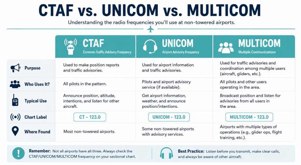
CTAF vs. UNICOM
UNICOM stands for Universal Communications.
At many non-towered airports, the airport’s UNICOM frequency is also the CTAF. Pilots use it both to announce traffic positions and to communicate with airport personnel for things like fuel requests or airport information.
That overlap is why you’ll often see a single frequency serving both purposes.
For drone pilots, the important point is that UNICOM does not automatically mean controlled airspace or active air traffic control. It usually indicates a non-towered airport environment where pilots are self-coordinating traffic.
CTAF vs. MULTICOM
MULTICOM is different.
MULTICOM frequencies are used at airports that do not have a tower, FSS (Flight Service Station), or UNICOM station available. In the U.S., 122.9 MHz is commonly associated with MULTICOM operations.
From a drone pilot’s perspective, MULTICOM serves a similar awareness role: it’s another indicator that aircraft may be coordinating traffic without direct air traffic control involvement.
You generally don’t need to memorize detailed radio procedures as a drone pilot.
But understanding the differences between CTAF, UNICOM, and MULTICOM can make sectional charts and airport references much easier to interpret.
How CTAF Is Used at Non-Towered Airports
At a non-towered airport, pilots coordinate traffic themselves instead of relying on an air traffic controller.
And that coordination usually happens over the CTAF.
A pilot approaching the airport may announce their position several miles out, then continue making calls while entering the traffic pattern, landing, taxiing, and departing.
The purpose is situational awareness. Everyone operating nearby can build a mental picture of where other aircraft are and what they’re planning to do.
For drone pilots, the key takeaway is that non-towered doesn’t mean inactive.
Many smaller airports are surprisingly busy, especially during:
- Flight training operations
- Agricultural flying seasons
- Weekend recreational flying
- Helicopter operations
- Local events or fly-ins
This diagram shows a simplified traffic pattern around a non-towered airport—and why aircraft may be operating at relatively low altitudes near the airport:

Aircraft near smaller, non-towered airports may operate at relatively low altitudes while entering or leaving the traffic pattern.
That’s one reason airport awareness matters during drone flight planning, even when the surrounding airspace initially appears simple.
The big takeaway for drone pilots: CTAF is less about rules for drone pilots and more about understanding the operating environment around nearby aircraft activity.
CTAF FAQs
Here are answers to some of the most commonly asked questions about CTAF.
What does CTAF stand for?
CTAF stands for Common Traffic Advisory Frequency. It’s the radio frequency pilots use to coordinate traffic near airports without an operating control tower.
Pilots use CTAF to share information about their position and intentions so other aircraft in the area can maintain awareness of nearby traffic.
Is CTAF only used at uncontrolled airports?
CTAF is primarily associated with non-towered airports, but a tower frequency may temporarily serve as the CTAF when a control tower is closed.
That’s one reason it’s helpful to think of CTAF as a traffic coordination tool rather than a specific type of airport or airspace designation.
Can CTAF and UNICOM be the same frequency?
Yes. At many airports, the UNICOM frequency also serves as the CTAF.
That’s why the two terms are often used interchangeably, even though they don’t mean exactly the same thing. CTAF refers to the advisory frequency itself, while UNICOM refers to the radio station that may provide that frequency.
Do drone pilots need to use CTAF?
Most drone pilots are not routinely communicating on CTAF frequencies during normal operations. CTAF is mainly relevant for airport awareness, sectional chart interpretation, and understanding nearby aircraft activity.
For most drone pilots, CTAF is a situational-awareness tool rather than a communication requirement.
Where do you find CTAF on a sectional chart?
The CTAF is usually printed near the airport symbol and airport information. On many charts, a circled “C” identifies the frequency.
The exact format can vary, but the CTAF is typically displayed alongside other airport communication frequencies and airport reference information.


