Chula Vista PD Use Drone to Capture Shooting Suspect, Providing Model Use Case of Its Drone as First Responder Program

BY Zacc Dukowitz
14 January 2021

In Chula Vista recently a good Samaritan was shot while following a car that had just been involved in a hit-and-run.

He had witnessed the hit-and-run, and he was chasing the car to try and record its license plate number so that he could report it to the police.

But when he got close enough to read the plate a teenager in the passenger seat leaned out and shot at him, hitting him in the head (he is in stable condition). Several witnesses to the shooting quickly called it in, including the man who was shot.

Chula Vista officers in the area listened to the incoming 911 calls via livestreaming—this is made possible thanks to the city’s groundbreaking Live911 program—and quickly began making their way to the scene.

At the same time, officers in the police station immediately deployed a drone to the location of the shooting—this is made possible thanks to the city’s Drone as First Responder program—so that they could get visuals on the unfolding situation before the officers could arrive.

drones-first-responder-chula-vista
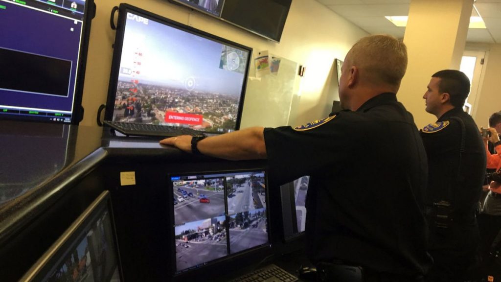
Officers monitor live video feed from a drone

Using the drone, officers at the station were able to fly to the scene and quickly identify the teenager suspected of shooting the man. They watched as he exited the hit-and-run vehicle holding a handgun and fled.

The drone helped police keep tabs on the shooting suspect until law enforcement was able to arrive in person and arrest him. The drone also helped provide visuals on the status of the shooting victim until emergency responders were able to arrive in person and administer aid.

Chula Vista’s High Tech Police Programs

This story is a textbook example of how the Chula Vista PD is using new technology to improve its police work.

chula-vista-shooting-suspect-arrest
Photo credit: Chula Vista Police Department

The department’s rapid, well-informed response was made possible through a combination of two novel programs designed to help police respond to emergencies as quickly as possible—the Live911 program and the Drone as First Responder (DFR) program.

Live911 Program

The Live911 program uses software developed specifically at the request of the Chula Vista Police Department to livestream 911 calls as they are made to officers who are out on patrol, providing them with details about emergencies in real time. The program also provides officers with the exact location of the caller on a map—information that was previously only available to dispatch.

In addition to the timeliness livestreaming calls provides, it also helps officers evaluate threat potential.

The details of a call could, on paper, make an officer anticipate the need for aggressive force. But the ability to hear the caller’s voice and temperament can help the officer add nuance to these facts, and prepare for what is actually happening on the scene.

And the difference can save lives.

For example, a woman called 911 saying that her son was at the door threatening her, and claiming to have a hammer and a gun. Since officers were able to listen to the call, they understood that this was an ongoing issue the mother had with her son, where he showed up claiming to have weapons (though never seemed to) and that he was actually not a real danger to the woman.

In the end they were able to contact the son, who had left the scene by the time they arrived, and calmly diffuse the situation.

Drone as First Responder Program

The Drone as First Responder program uses Chula Vista’s BVLOS COA to deploy a drone immediately to the scene of a 911 call so that officers can be monitoring it virtually before those on patrol can arrive in person.

Two key benefits to having eyes on a scene prior to the arrival of officers are that suspects can be located and followed (as in the story above), and that officers can have a sense of what to expect on the scene, so they won’t be ambushed or surprised.

Drones as First Responders in Action

The overall impact of these two programs working together is that officers can respond to the reality of an unfolding emergency quickly and efficiently, as they did when arresting the suspected teenage shooter who opened fire on the good Samaritan.

Chula Vista’s Permissions for the DFR Program

The Chula Vista Police Department has been on the cutting edge of the use of drones in public safety for several years.

It was the first police department in the U.S. to receive a COA to fly Beyond Visual Line of Sight (BVLOS), and when the first wave of COVID-19 hit back in March it was the first police department to use drones to help fight its spread.

Much of Chula Vista’s early progress in the use of UAS for law enforcement, and the BVLOS COA specifically, were a result of its involvement in the UAS IPP (UAS Integration Pilot Program) through its partnership with the neighboring city of San Diego.

Although the IPP officially ended a few months back in October, the permissions it helped the Chula Vista PD obtain are still in place.

As time passes, we’re sure to hear more stories about the use of these two programs to improve policing in Chula Vista, and may see adoption spread to other cities throughout the U.S.

Know of other public safety agencies using drones to improve their processes? Share what you know in this thread on the UAV Coach community forum.

Join a global community of

100,000+

drone enthusiasts.

Subscribe

Drone Pilot's Guide to DJI Mini 4 Pro

  • Navigate the DJI Fly app and flight modes with ease
  • Adjust camera and safety settings for better control
  • Understand intelligent flight features and how to use them
  • Avoid common beginner mistakes
  • Get the most out of your drone—without the guesswork

Drone Pilot's Guide to DJI Air 3S

  • Navigate the DJI Fly app and flight modes with ease
  • Adjust camera and safety settings for better control
  • Understand intelligent flight features and how to use them
  • Avoid common beginner mistakes
  • Get the most out of your drone—without the guesswork

Hands-On Flight Training

$295

400+ 5-Star Reviews

  • Team up with a knowledgeable, friendly instructor at a convenient outdoor spot — like a park or athletic field
  • Fly a top-rated drone provided for you, or bring your own to get personalized guidance
  • Spend most of your time in the air with hands-on practice — learning about composition, camera angles and cinematic motion
  • Explore the DJI Fly app and learn how to use camera settings like ISO, shutter speed and aperture
  • Unlock the power of Intelligent Flight Modes to fly smoother, smarter, and with less stress
  • Get access to our Aerial Photo & Video online course with additional exercises and pro-level editing workflows – using Snapseed, Photopea, Adobe Lightroom, DJI LightCut, and Premiere Pro

Aerial Photo & Video for Drone Pilots

$179

3,500+ 5-Star Reviews

  • How to dial in the right camera settings like ISO, shutter speed, and aperture
  • The best angles & altitudes for different types of shots (real estate, landscapes, cityscapes, and more)
  • The secret to cinematic drone motion that makes your footage feel like a Hollywood movie
  • How to enhance colors, remove distractions, and sharpen details – even in tricky lighting
  • Pro-level editing workflows – whether you’re using Lightroom, free tools, or mobile apps

The Recreational UAS Safety Test

Free

150+ 5-Star Reviews

  • Required for U.S. recreational flyers of drones
  • Launched June 2021 by the FAA
  • Takes about 30 minutes to complete
  • No prior drone knowledge needed
  • Test allows unlimited attempts to pass

Drone Mapping Essentials Workshop

$799

3,500+ 5-Star Reviews

  • Expert instruction from expert drone pilots with over 100 hours of flying experience
  • Hands-on training of live data capture and how to process deliverables for your clients
  • Peer-to-peer networking with other professional drone pilots in the mapping industry
  • Free access to the online course, Drone Mapping Essentials

Flight Skills for Drone Pilots

$99

75+ 5-Star Reviews

  • 16 engaging video lectures with key takeaways
  • Action items with concrete steps so you put into practice what you learn
  • Pre-flight checklists to help you plan your flights
  • Resource links to websites, products and software for further learning and discovery

Drone Business & Mapping Bundle

$617 $397

3,500+ 5-Star Reviews

  • Drone Pilot Ground School
    1. 1:1 support with a Part 107 exam success coach
    2. Study 100% online at your own pace
    3. Unlimited practice exams with 400+ real FAA test questions
  • Drone Mapping Essentials
    1. 100+ instructional videos focused on real-world application with high-quality videos
    2. Downloadable resources like data capture checklists to utilize in your missions
    3. Monthly live instruction with course instructor, Dylan Gorman, to go deeper on topics where you need more clarification
  • The Drone Business Blueprint
    1. Expert instruction from industry veteran, Eno Umoh, who brings real-world experience in building successful drone businesses.
    2. 14 Comprehensive modules covering everything from business setup to marketing strategies
    3. 30 Downloadable resources to apply your learning immediately

Hands-On Flight Training

$295

400+ 5-Star Reviews

  • 45-60 minutes of hands-on flying time to master orientation and flight maneuvers tailored to your skill level
  • Learn how to handle obstacles such as lost GPS, low battery charge or emergencies
  • Practice flying under various intelligent flight modes
  • Ask questions about regulations, software, flight operations management, and more

The Drone Business Blueprint

$119

3,500+ 5-Star Reviews

  • Expert instruction from industry veteran, Eno Umoh, who brings real-world experience in building successful drone businesses.
  • 14 Comprehensive modules covering everything from business setup to marketing strategies
  • 30 Downloadable resources to apply your learning immediately
  • AI tools and techniques to boost productivity and streamline your operations

Commercial Drone Business Bundle

$418 $334

4,000+ 5-Star Reviews

  • Drone Pilot Ground School
    1. 1:1 support with a Part 107 exam success coach
    2. Study 100% online at your own pace
    3. Unlimited practice exams with 400+ real FAA test questions
  • The Drone Business Blueprint
    1. Expert instruction from industry veteran, Eno Umoh, who brings real-world experience in building successful drone businesses.
    2. 14 Comprehensive modules covering everything from business setup to marketing strategies
    3. 30 Downloadable resources to apply your learning immediately

Drone Mapping Essentials

$199

3,500+ 5-Star Reviews

  • 100+ instructional videos focused on real-world application with high-quality videos
  • Downloadable resources like data capture checklists to utilize in your missions
  • Quizzes to test your knowledge so you can succeed in the field
  • Monthly live instruction with course instructor, Dylan Gorman, to go deeper on topics where you need more clarification

Drone Pilot Pro Bundle

$713 $499

3,500+ 5-Star Reviews

  • Drone Pilot Ground School
    1. 1:1 support with a Part 107 exam success coach
    2. Study 100% online at your own pace
    3. Unlimited practice exams with 400+ real FAA test questions
  • Drone Pilot Skill Builder
    1. 16 engaging video lectures with key takeaways
    2. Action items with concrete steps so you put into practice what you learn
  • Hands-On Flight Training
    1. 45-60 minutes of hands-on flying time to master orientation and flight maneuvers tailored to your skill level

Drone Pilot Ground School

$299

4,000+ 5-Star Reviews

  • 1:1 support with a Part 107 exam success coach
  • Study 100% online at your own pace
  • Unlimited practice exams with 400+ real FAA test questions
  • Personalized study plans, virtual flashcards, and 12-page cram sheet
  • Weekly webinars on acing the Part 107 exam and monthly webinars to elevate your journey post-certification