

Drones in Agriculture: The Best Agricultural Drones of 2025 & More
BY Zacc Dukowitz
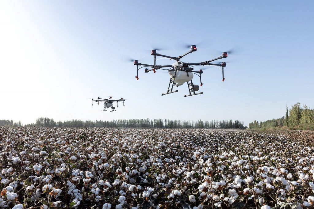
11 February 2026Agricultural drones are uncrewed aerial vehicles (UAVs) used in farming to collect data, monitor crops, and perform tasks like mapping, spraying, and seeding with speed and precision.
Commonly called farm drones or agriculture drones, these aircraft are used for:
- Collecting crop health data using visual, thermal, multispectral, or hyperspectral sensors to identify stress, pests, disease, and nutrient deficiencies
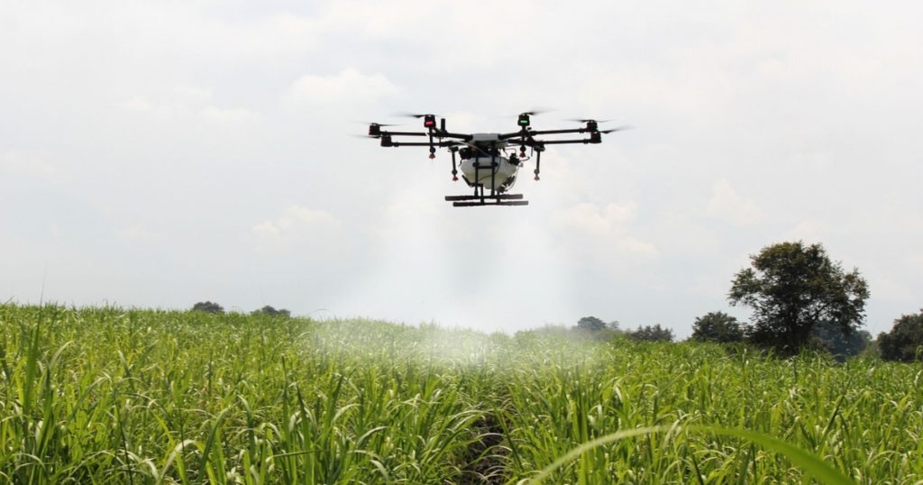
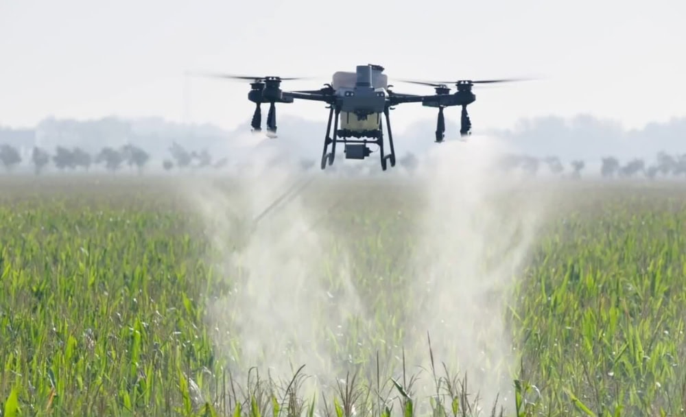
- Spraying crops with fertilizers, herbicides, or pesticides using drones specifically designed for aerial application with liquid tanks and nozzles
The global market for drones in agriculture is expected to grow to over $10 billion by 2030, driven by rising demand for precision farming and labor-saving tools. As the technology improves, drones are becoming a standard tool on farms of all sizes—used for crop scouting, aerial mapping, spraying, and more.
In this guide, we’ll break down how agricultural drones work, what they’re used for, and which models are best for farm operations in 2025.
- Best Drones for Agriculture in 2025
- How Are Drones Used in Agriculture?
- Types of Agricultural Drones
- 5 Main Benefits of Using Drones in Agriculture
- 4 Disadvantages of Using Drones in Agriculture
- Agriculture Drone Services and Pricing
- Agricultural Drones FAQ
Best Drones for Agriculture in 2025
The best agriculture drones in 2025 offer powerful tools for mapping, monitoring, and spraying—tailored to meet the needs of different farm sizes and crop types.
Whether you’re a precision ag consultant, a row crop farmer, or a viticulture specialist, there’s a drone for your operation.
Here are the top models on the market this year.
1. DJI Agras T50

The Agras T50 is DJI’s newest heavy-duty spraying drone, designed for large-scale farms. It features a dual-nozzle system and advanced obstacle sensing, making it one of the most capable drones for automated crop treatment.
Why it’s good for agriculture: Covers wide areas quickly with high-volume tanks and precision variable-rate spraying.
- Max payload. 88 lbs. (40 kg) spray tank / 110 lbs. (50 kg) spreader
- Flight time. Up to 15 minutes fully loaded
- Obstacle avoidance. Dual radar + binocular vision sensors
- Navigation. RTK-enabled for centimeter-level accuracy
Learn more about the Agras T50.
2. DJI Agras T25

Smaller than the T50, the Agras T25 is a lightweight crop spraying drone designed for medium-sized farms and orchard work. It offers many of the same features as the T50 in a more compact frame.
Why it’s good for agriculture: Ideal for smaller farms or tighter field conditions requiring efficient and precise coverage.
- Max payload. 44 lbs. (20 kg) spray tank / 55 lbs. (25 kg) spreader
- Flight time. Up to 18 minutes (spraying)
- Navigation. RTK-enabled for accurate targeting
- Portability. Foldable design for easier transport
Learn more about the Agras T25.
3. DJI Mavic 3 Multispectral
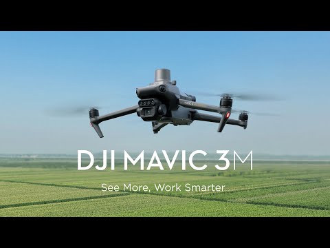
This compact multispectral drone is a go-to choice for crop scouting, NDVI mapping, and plant health analysis. It integrates RGB and multispectral sensors in a small, efficient package.
Why it’s good for agriculture: Affordable and portable option for precision agriculture data collection and monitoring.
- Imaging. RGB + 4 multispectral bands (Green, Red, Red Edge, NIR)
- Flight time. Up to 43 minutes
- Navigation. RTK module included for centimeter-level accuracy
- Weight. 2 lbs. (0.9 kg)
Learn more about the Mavic 3 Multispectral.
4. SenseFly eBee Ag
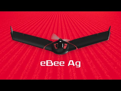
The eBee Ag is a fixed-wing mapping drone built for broad-acre crop analytics. It’s made for collecting large-scale, high-resolution NDVI and multispectral data.
Why it’s good for agriculture: Designed for large field coverage and compatible with industry-standard agronomic software.
- Imaging. RedEdge-MX multispectral camera
- Flight time. Up to 55 minutes
- Coverage. Up to 395 acres (160 ha) per flight
- Navigation. RTK/PPK ready
Learn more about the senseFly eBee Ag.
5. XAG V40
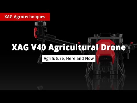
The XAG V40 is a fully autonomous spray drone with dual rotors, designed for row crops, orchards, and specialty agriculture. It’s known for its smart flight systems and rugged design.
Why it’s good for agriculture: Fully autonomous spraying and terrain tracking make it ideal for complex topographies.
- Max payload. 44 lbs. (20 liters) spray tank
- Flight time. Up to 15 minutes (spraying)
- Autonomy. AI-powered flight planning and terrain following
- Spraying system. Supports variable-rate application
How Are Drones Used in Agriculture?
Agricultural drones are used to collect data, manage crops, and perform key tasks more efficiently than traditional methods. From early-stage field scouting to targeted spraying, these tools have become a central part of precision agriculture.
Here are the most common ways drones are used in agriculture today:
1. Crop Monitoring
Crop health monitoring is one of the most common applications for farm drones.
High-resolution cameras and multispectral sensors give farmers a full view of how crops are performing—revealing issues early and helping guide in-season decisions.
How drones help with crop monitoring:
- NDVI and multispectral imagery. These visual layers detect changes in plant health and vigor, revealing underperforming zones before symptoms are visible to the eye.
- Growth stage tracking. Aerial images help estimate crop development and uniformity across large fields.
- Stand counts. Early-season images are used to estimate plant population and identify gaps for potential replanting.
2. Mapping and Surveying
Mapping drones create high-resolution field maps used for planning, analysis, and documentation. Farmers use these outputs to track field variability, inform input decisions, and manage equipment more efficiently.
How drones help with mapping and surveying:
- Orthomosaic maps. These stitched, geo-referenced images provide a clear, accurate view of the entire field surface.
- 3D terrain models. Elevation data is used to plan drainage, identify slopes, and improve equipment routing.
- Field boundary and area measurements. Accurate acreage data supports planting plans, variable rate prescriptions, and compliance reporting.
3. Irrigation and Water Stress Management
Drones with thermal or multispectral sensors help spot areas of over- or under-watering. These insights support better irrigation planning and more efficient water use.
How drones help with irrigation and water stress management:
- Thermal imaging. Temperature differences across the field highlight zones with moisture stress or blocked irrigation.
- Vegetation indices. Multispectral maps reveal signs of water deficiency not visible in standard RGB imagery.
- Irrigation uniformity checks. Visual overlays show whether irrigation systems are performing consistently across the field.
4. Pest and Disease Detection
Drones allow farmers to spot crop damage from pests, weeds, or disease early—before symptoms spread or become irreversible. This enables more precise intervention.
How drones help with pest and disease detection:
- High-resolution RGB imagery. Helps identify signs of insect feeding, discoloration, or lodging at the plant level.
- Multispectral imagery. Highlights stressed zones that may indicate early-stage infections or infestations.
- Damage mapping. Drones help measure the extent of impact after a pest outbreak or weather event.
5. Variable Rate Application
Spraying and spreading drones use prescription maps or real-time imagery to apply materials where needed—reducing waste and improving results. This includes seeding, fertilizer, and pesticide delivery.
How drones help with variable rate application:
- Spot spraying. Apply chemicals only to infested or problem areas, minimizing input costs and runoff.
- Fertilizer application. Use drone-generated maps to guide targeted application based on soil or crop condition.
- Drone seeding. Seed cover crops or hard-to-access areas with precision and speed.
6. Livestock Monitoring
In ranching and mixed operations, drones are used to locate herds, inspect fence lines, and check remote areas—reducing the need for manual patrols or ATV trips.
How drones help with livestock monitoring:
- Herd location and movement checks. Real-time visuals help monitor herd behavior and spot missing animals.
- Fence and perimeter inspection. Aerial surveys detect breaches, fallen wires, or structural issues along property lines.
- Remote area monitoring. Drones can check water sources, feed stations, and back pasture conditions without physical travel.
Types of Drones in Agriculture
There are three main types of drones used in agriculture: fixed-wing, multi-rotor, and hybrid drones.
Each type is designed to serve different agricultural needs, from wide-area mapping to precision spraying. Understanding these categories can help farmers and service providers choose the right tool for the job.
Here’s an overview:
| Drone Type | Flight Time | Payload Capacity | Common Uses in Agriculture |
|---|---|---|---|
| Fixed-Wing | 60–90 minutes | Low to Medium | Wide-area surveying, orthomosaic mapping, crop health monitoring |
| Multi-Rotor | 15–40 minutes | Medium to High | Spraying, spot inspections, thermal analysis, plant counting |
| Hybrid (VTOL) | 90–180 minutes | Medium | Large-scale mapping in remote areas, combining vertical takeoff with long endurance |
5 Main Benefits of Using Drones in Agriculture
What are the benefits of using drones in agriculture?
As drone adoption grows, farmers are seeing major improvements in efficiency, cost savings, and crop performance. Here are the top advantages of agricultural drone use:
1. Time Savings
Drones can cover hundreds of acres in a single flight, drastically reducing the time required for crop scouting, mapping, or spraying.
2. Labor Cost Reduction
Tasks that once took multiple workers and days—like surveying or monitoring—can now be done faster with fewer personnel.
3. Improved Crop Health Insights
Multispectral and thermal sensors detect crop stress, pests, or disease early, helping farmers take timely action and minimize damage.
4. Optimized Input Usage
Drones support precision application of fertilizers, pesticides, and water, reducing waste and saving money while protecting the environment.
5. Better Yield Forecasting
High-resolution imagery and data analysis tools improve accuracy in tracking crop growth and estimating yields across a season.

4 Disadvantages of Using Drones in Agriculture
While agricultural drones offer major advantages, there are still some practical limitations to consider.
Here are the four main disadvantages of using drones in agriculture:
1. High Upfront Cost
Many professional agriculture drones cost several thousand dollars, not including sensors, software, or training.
2. Technical Training Required
Operating drones effectively and interpreting data outputs requires training in both flight and software tools.
3. Limited Flight Time
Most multi-rotor drones can only fly for 20–40 minutes, requiring multiple flights or battery swaps to cover large farms.
4. Legal and Regulatory Barriers
Pilots must follow FAA regulations, including Part 107 certification and airspace restrictions, which can limit operations in some areas. Also, flying Beyond Visual Line of Sight (BVLOS) is prohibited by the FAA without special permission, which can make flying over large farms challenging.
Agriculture Drone Services and Pricing
Agriculture drone pilots offer a range of services designed to support crop management, input optimization, and farm efficiency. These services are commonly hired by farmers, agronomists, co-ops, or crop consultants looking for better data and automation.
Drone service pricing can vary based on acreage, data resolution, local market rates, and whether pilots offer one-time jobs or seasonal contracts. High-volume clients, such as large farms or cooperatives, often negotiate bulk pricing or recurring service packages.
Pricing is usually based on acreage, service type, and deliverables. Rates may be hourly or project-based, but most services are charged per acre.
Here’s a breakdown of common agriculture drone services, what they include, how much they cost, and how much drone pilots can potentially earn.
1. NDVI and Multispectral Mapping
Used to detect plant stress, disease, and nutrient deficiencies early in the growing season.
- Typical pricing: $8–$20 per acre, depending on resolution and post-processing
- Drone pilot revenue example: Scanning 500 acres at $10/acre = $5,000 per job
- Deliverables: NDVI maps, plant health reports, field variability heatmaps
2. Thermal Imaging and Water Stress Detection
Used to monitor irrigation efficiency and identify areas suffering from drought stress.
- Typical pricing: $10–$25 per acre
- Drone pilot revenue example: 100-acre vineyard at $15/acre = $1,500 per scan
- Deliverables: Thermal maps, irrigation uniformity reports
3. Stand Counts and Crop Emergence Analysis
Helps assess early crop establishment and evaluate planter performance.
- Typical pricing: $5–$15 per acre
- Drone pilot revenue example: 200-acre cornfield at $10/acre = $2,000 per job
- Deliverables: Plant population counts, emergence heatmaps, gap analysis
4. Precision Spraying and Spreading
Spraying fertilizers, pesticides, or cover crop seeds using specialized drones.
- Typical pricing: $10–$40 per acre
- Drone pilot revenue example: 100-acre fungicide application at $25/acre = $2,500 per job
- Deliverables: Spraying logs, GPS flight records, application summaries
5. 2D and 3D Field Mapping
Used for topographic surveys, elevation models, and drainage planning.
- Typical pricing: $7–$25 per acre
- Drone pilot revenue example: 300 acres at $15/acre = $4,500 per job
- Deliverables: Orthomosaics, digital surface models (DSMs), contour lines
6. Agronomic Reporting and Data Analysis
Combining multiple data layers for actionable insights and recommendations.
- Typical pricing: Often included in bundled packages or charged hourly ($50–$150/hr)
- Drone pilot revenue example: Monthly subscription of $1,000–$3,000 per farm
- Deliverables: Custom reports, trend analysis, variable rate prescriptions
Agricultural Drones FAQ
Here are answers to the most commonly asked questions about drones in agriculture.
What is an agriculture drone?
An agriculture drone is a type of unmanned aerial vehicle (UAV) designed for use in farming. These drones help with crop monitoring, spraying, mapping, and data collection to support precision agriculture practices.
How much does an agricultural drone cost?
Agricultural drones vary widely in price. Entry-level mapping drones may cost $2,000–$5,000, while advanced spraying drones like the DJI Agras T50 can exceed $15,000–$20,000 depending on payload and features.
Do you need a license to fly drones on a farm?
Yes, if you’re using a drone for commercial purposes—such as crop scouting, mapping, or spraying—you must have an FAA Part 107 Remote Pilot Certificate. This certification is required for any commercial drone operation in the U.S., including those on private farmland.
However, if you’re using drones to apply chemicals like pesticides, herbicides, or fertilizers, you also need to comply with Part 137 regulations, which govern agricultural aircraft operations. This includes additional FAA approvals such as an agricultural aircraft operator certificate, and the drone and pilot must meet specific equipment and operational requirements. You may also need state-level approvals for chemical application.
Can drones spray crops?
Yes, specialized agricultural drones are built to spray crops with fertilizers, pesticides, or herbicides. These drones use precision GPS and flow control systems to apply inputs accurately and reduce waste.
What’s the difference between a mapping drone and a spraying drone?
Mapping drones are equipped with RGB, multispectral, or thermal cameras to collect visual and analytical data about crops. Spraying drones, on the other hand, are designed with tanks and nozzles to apply liquid inputs across fields.
How do drones help improve crop yield?
Drones support better decision-making by identifying crop stress, pest outbreaks, or water issues early. By responding quickly to these issues, farmers can protect plant health and optimize input use, leading to improved yield outcomes.
What are the benefits of using drones in agriculture?
Drones save time and reduce labor costs while providing actionable insights through imagery and data. They help farmers make faster, more accurate decisions about irrigation, inputs, and harvest timing.


