

Absolute Location vs. Relative Location: A Guide for Drone Pilots
BY Zacc Dukowitz
14 February 2026In simple terms, absolute location refers to a specific point on the Earth’s surface, defined by fixed coordinates like latitude and longitude. Relative location, on the other hand, describes a place in relation to other features—such as “north of the tower” or “next to the bridge.”
Understanding where you are—and where you’re flying—is at the heart of every drone operation. That’s why learning the difference between absolute location and relative location is such an important skill for drone pilots.
Both concepts are key to modern drone operations.
Whether you’re planning precise mapping flights or coordinating with a ground crew in the field, understanding absolute location and relative location can help improve your flight planning, data accuracy, and operational safety.
This guide to absolute and relative location is written for commercial drone pilots operating under Part 107, drone hobbyists looking to sharpen their skills, and GIS professionals and surveyors who want to apply these concepts to drone work.
Here’s a menu in case you want to jump around:
- What Is Absolute Location?
- What Is Relative Location?
- Absolute Location vs. Relative Location: What’s the Difference?
- Why Absolute Location Matters in Drone Operations
- Why Relative Location Matters in Drone Operations
- Absolute and Relative Location in Advanced Drone Workflows
- Absolute Location vs. Relative Location FAQ
What Is Absolute Location?
Absolute location is the exact position of a point on the Earth’s surface, expressed using a set of coordinates.
The most common way to define absolute location is through latitude and longitude—a pair of numbers that describe a specific place anywhere in the world.
For example, the coordinates 37.7749° N, 122.4194° W identify a precise point in San Francisco, California. This type of positioning does not depend on other landmarks or surroundings—it is a fixed reference that remains constant, no matter what changes happen in the environment.
- In geography, absolute location gives us a universal way to describe places. It is the foundation for everything from global navigation to digital mapping.
- In drone operations, knowing the absolute location of your takeoff point, flight path, and targets is critical for accurate data collection and safe, compliant flights.

There are several tools drone pilots use to determine absolute location in the field, including:
- GNSS (Global Navigation Satellite Systems)
- GPS (Global Positioning System)
- RTK (Real-Time Kinematic) positioning
- As well as various mapping software platforms
By working with absolute location data, pilots can plan precise missions, execute automated flight paths, and generate accurate maps and models—all essential for professional drone work.
What Is Relative Location?
Relative location describes where something is in relation to other places or objects.
Instead of using fixed coordinates, it uses references like landmarks, distances, or directions. For example, you might describe a location as being 200 feet north of a water tower, or just beyond the west fence line of a property.

In geography, relative location helps us understand how places connect and interact with their surroundings.
It’s flexible and dynamic—which brings us to an important point: yes, relative location can change. If a landmark moves, if a temporary structure is added, or if a natural feature like a river shifts, the way you describe relative location also changes.
Examples of relative location include descriptions like next to the construction crane, behind the maintenance building, or east of the main road.
In drone operations, this kind of language is often used in the field. A pilot might tell a visual observer to watch for air traffic coming from the direction of a water tower, or direct a drone to hover near a specific tree line.
In search and rescue, when scanning a wooded area a pilot might spot an object and radio its relative location: 100 meters northwest of the old barn. In situations where time matters, relative location provides a fast, flexible way to communicate and coordinate with a team—even in areas where GPS signals may be limited.
Absolute Location vs. Relative Location: What’s the Difference?
The difference between absolute and relative location comes down to precision versus context.
- Absolute location gives you an exact, fixed point on the Earth’s surface, expressed through coordinates like latitude and longitude.
- Relative location, by contrast, describes a place in relation to other features—it depends on the surroundings and can shift as those surroundings change.
Both are useful in different ways for drone operations.
Absolute location is key for mapping, photogrammetry, and automated flights where accuracy is critical. Relative location helps with situational awareness, field communication, and navigating complex environments where landmarks matter more than coordinates.
Here’s a quick comparison:
| Absolute Location | Relative Location |
|---|---|
| Exact position (latitude/longitude coordinates) | Position described in relation to other objects or landmarks |
| Does not change over time | Can change if surroundings change |
| Used for mapping, navigation, automated flight | Used for situational awareness and communication |
| Determined with GNSS, GPS, RTK, mapping tools | Described using visual cues, verbal callouts, field observations |
Most professional drone pilots use both absolute location and relative location every day.
For example, you might set an automated survey grid using absolute location, then use relative location to direct a spotter to monitor airspace near a crane or power line.
By understanding the strengths of each, you can plan safer flights, gather more accurate data, and communicate more effectively with your team.
Why Absolute Location Matters in Drone Operations
Absolute location is one of the most important concepts in professional drone work because so many mission types depend on accurate positioning.
Without precise location data, it would be impossible to create survey grids, perform photogrammetry, or produce high-quality orthomosaic maps.
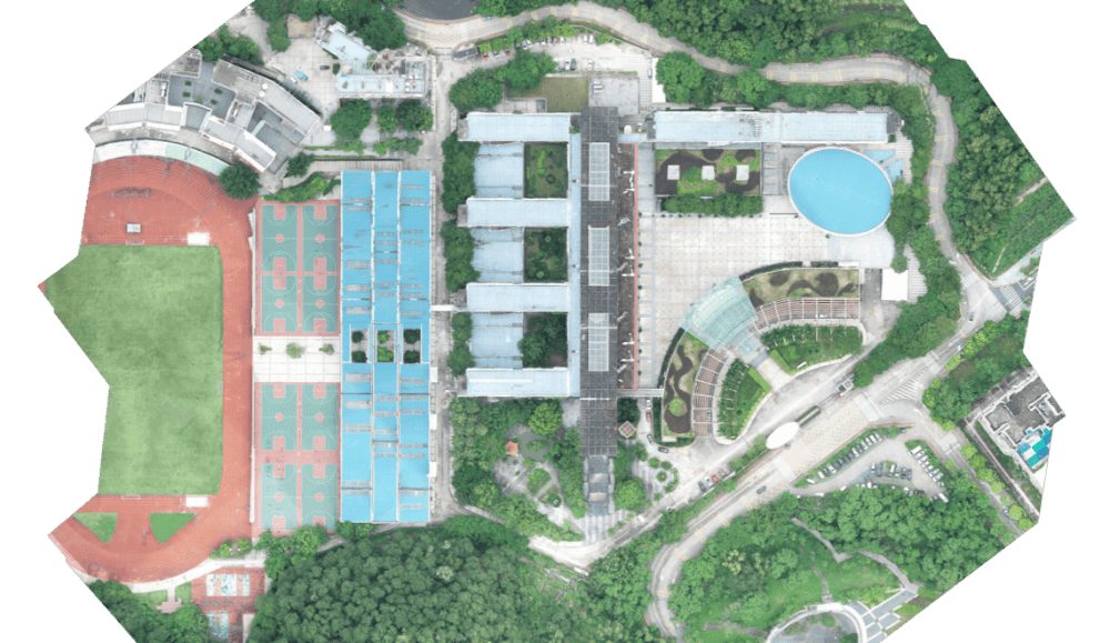
An orthomosaic map made with drone data | Credit: DJI
When you program a mapping mission, each flight line and photo capture point is defined by latitude and longitude.
The drone’s onboard GNSS (Global Navigation Satellite System) receiver, or in many cases an RTK (Real-Time Kinematic) GPS unit, allows it to navigate with high precision. This is how drones maintain consistent overlap and ground sampling distance when capturing imagery for mapping or 3D modeling.
Absolute location is also essential for BVLOS (Beyond Visual Line of Sight) and automated flights. In these missions, there may be no visual reference to track the drone’s position. The aircraft must rely entirely on its absolute location data to follow the programmed path and avoid restricted areas.
Another key reason absolute location matters is legal compliance.
Under the FAA’s Part 107 rules—the rules that govern all commercial drone operations—drone pilots must operate within controlled airspace boundaries and maintain required separation from restricted areas, structures, and people.
By understanding and monitoring absolute location, you can ensure your drone stays in authorized airspace and avoids potential violations.
Why Relative Location Matters in Drone Operations
Relative location plays an equally important role in drone operations, because not every situation calls for exact coordinates.
In the field, drone pilots often rely on relative location to improve navigation, enhance situational awareness, and coordinate safely with team members.
When operating near structures, landmarks, or in areas with changing conditions, relative location makes communication more effective.
For example, a pilot might direct a visual observer to watch for manned aircraft approaching from the south side of a tower or call out an object of interest as being west of the landing zone. These verbal callouts are faster and more intuitive than reading coordinates, especially in high-tempo environments.

Credit: 4Blades Digital
Relative location is critical for safety in dynamic environments like construction sites, public events, or emergency response missions.
In these scenarios, both the environment and the drone’s mission requirements can change rapidly. Using relative location helps pilots and ground crews adapt and communicate clearly in real time.
Another important use is mission coordination with visual observers and ground teams. If a visual observer spots an obstacle or potential hazard, it’s much easier to describe its relative position (“just beyond the second crane”) than to share exact GPS coordinates in the moment.
Absolute and Relative Location in Advanced Drone Workflows
Most experienced drone pilots don’t rely on just one way of thinking about location—they use both absolute and relative location together to plan, fly, and communicate more effectively.
For mapping and inspection work, absolute location is the foundation. Accurate coordinates ensure your flight paths align perfectly with your intended coverage area. This is critical for applications like photogrammetry, topographic surveys, and infrastructure inspections, where data quality depends on precision.
But once you’re on-site, relative location comes into play. A pilot might describe an unexpected obstacle as being just east of a control point or direct an observer to monitor a section of the site using familiar landmarks.
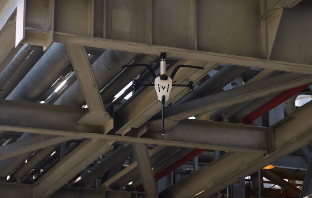
A Voliro drone collects inspection data | Credit: Voliro
Many drone teams also work with GIS platforms that incorporate both types of location.
For example, a GIS layer might display absolute coordinates for utility poles while also allowing teams to tag inspection notes with relative references like pole number or its position along a line segment.
The ability to think in both absolute and relative terms makes it easier to communicate findings and coordinate with stakeholders who may not be looking at raw coordinates.
Dynamic geofencing and live mission updates are another area where both concepts come together.
A geofence might be drawn using absolute coordinates, but responding to a moving hazard—like a crane swinging into a flight path—requires real-time relative location awareness. In these cases, drone pilots must constantly adjust based on both fixed data and dynamic field conditions.
Absolute and Relative Location Across Industries
Here’s how location plays a role in some of the most common commercial drone applications:
- In construction, pilots use absolute location for precise survey flights and relative location to coordinate with ground crews.
- In utilities, crews may inspect assets based on exact coordinates but reference nearby landmarks during flight.
- In search and rescue, teams often rely on relative location—such as calling out a victim’s position in relation to a trail or structure—while tracking aircraft using GPS.
- In agriculture, absolute location guides automated flight paths for crop mapping, while relative location helps pilots visually monitor problem areas within a field.
- In public safety, law enforcement and fire crews use absolute location to track drone positions on mapping tools, while using relative callouts to direct units on the ground.
- In real estate marketing, pilots may fly automated orbits based on absolute location but use relative references when setting up shots around property features.
Absolute Location vs. Relative Location FAQ
Here are answers to the most commonly asked questions about absolute location, relative location, and their relevance to drone operations.
What is absolute location?
Absolute location refers to an exact, fixed point on the Earth’s surface. It is most commonly expressed using latitude and longitude coordinates that do not change, no matter what is happening in the surrounding environment.
What is relative location?
Relative location describes where something is in relation to other places or landmarks. It is flexible and often based on directions, distances, or visual references—like saying an object is “north of the tower” or “behind the maintenance shed.”
What is the difference between absolute and relative location?
The difference between absolute and relative location is that absolute location gives you precise coordinates, while relative location describes a place in relation to other features. Both are useful for different aspects of flight planning and field communication.
Can relative location change?
Yes. Relative location can change if the landmarks or features it references change. For example, if a crane is moved on a construction site, its relative position to other objects will also change.
What is absolute location in geography?
In geography, absolute location is the exact position of a point on the Earth, defined by latitude and longitude or another coordinate system. It is a universal reference used in mapping, navigation, and global positioning systems.
How is relative location important for drone operations?
Relative location is important for drone operations because it improves on-the-ground communication, situational awareness, and coordination with visual observers or crew members. It helps pilots adapt to dynamic environments and describe positions quickly using familiar landmarks.
Why is absolute location important for drone operations?
Absolute location is critical for precise mission planning, automated flight paths, mapping, and legal compliance with airspace boundaries. It ensures that drones follow accurate routes, stay within authorized zones, and collect reliable data.


