An Introduction to UAV Photogrammetry Software
BY Jeremy Jensen
9 May 2019It’s no secret how incredible drones are for capturing aerial images. If you logged onto Instagram right now you might even see a few cross your feed.
Despite how popular and accessible taking images from the sky has become, many people have yet to realize that the demand for drone images has rapidly grown for more objective, commercial purposes. While many drone operators are capturing for the artistic and hobbyist side of the industry, others have begun using the photos for highly technical mapping and modeling applications.
Photogrammetry is the science of using images to map and measure distances, which we’ll be going over in depth for you in this article.
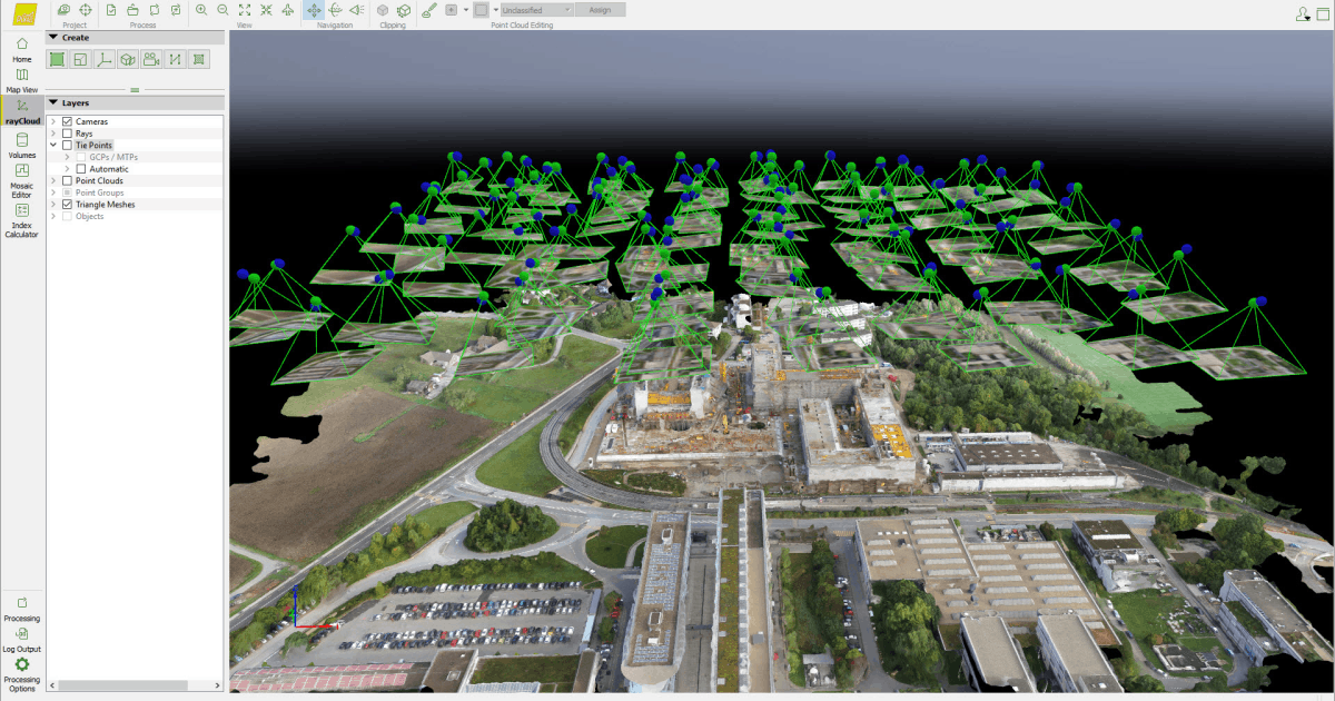
Image Source: Pix4D
What is Photogrammetry?
The minimalist definition of photogrammetry would be: using photos to make measurements.
The definition becomes much broader and more technical depending on the objective for each intended application. While using unmanned aerial vehicles (UAVs), also called drones, for the imaging portion of the job are brand new and revolutionizing the capabilities, computational photogrammetry has been around since the first desktop computers in the 1980s.
Modern tools are increasing access to these efforts, allowing our society to record data and monitor our environments like never before. The process begins by taking large batches of meticulously captured 2D photographs, that are later run through software to create 3D digital models, topographic renderings, or simulations of weather patterns. The hardware to software integration in new technology is so advanced the majority of photogrammetry operations will happen automatically.
Photogrammetry can be classified in a variety of ways. One approach is to split the field based on where your camera is located during photography.
[Related read: Drone Photogrammetry—An In-Depth Guide]
Aerial, Terrestrial, and Close-Range Photogrammetry
What used to require a manned aircraft and sophisticated camera-stability tools is now being taken on in large numbers by UAVs. While using a manned aircraft might seem excessive given the ease of operating a drone, there are still many applications of aerial photogrammetry that require an image to be taken well over 400 feet in the air (FAA regulations prohibit drone operations above 400 feet without a waiver).
Aerial photogrammetry requires multiple overlapping shots, often up to 80% of the previous image, in order to accurately construct a large format image in ultra-high resolution. The majority of this post will be dedicated to how UAVs apply in aerial photogrammetry situations.
The main difference in terrestrial photogrammetry is that it is typically non-topographic, as shooting from the ground will make it much more difficult to plot large areas of varying elevations. Terrestrial modeling focuses on measuring buildings, engineered structures, film sets, mines, etc.
Close-range photogrammetry classifies any operation that is being captured within 1,000 feet of the subject. This will be the case most often when flying drones as you will likely be no more than a couple hundred feet away from your survey site.
We will be focusing on aerial applications; however, it’s good to know the foundations if you want to dabble in both fields.
Common Applications of Aerial Photogrammetry
Now that we’ve covered the basic process (taking photos and then using them to acquire measurement data), what are some of the most common applications of aerial photogrammetry?
Construction
Construction happens in phases, and drone mapping allows contractors to analyze progress, stockpiles of raw materials, and even generate 3D models of their sites. Those who use the tool have claimed higher ROI’s on projects due to the increased efficiency.
Land Surveying
Land Surveyors have one of the most useful applications of aerial mapping, with a good example being maps that determine legal boundaries. Land surveying is also much more employable via UAV pilots based on cost and agility than the traditional use of manned aircraft.
Real Estate
Realtors love the recent ability to document land parcels for sale in high resolution. Satellite imagery gives a decent overview, but when it comes to buying large parcels of land investors will want to see the area in clear detail, and with accurate boundary measurements.
Agriculture
The agriculture industry has been one of the fastest to adopt full drone fleets with wide varieties of functions. Mapping gives farmers the ability to efficiently analyze their crops for data related to overall crop health, land distribution, and light distribution.
To read more about the drone mapping use cases by industry check out A Beginner’s Guide to Drone Mapping.
How Drone Pilots Capture Images To Effectively Use With Photogrammetry Software
Anytime you fly a drone to capture imagery for photogrammetry applications you will want to approach the capturing process with certain benchmark objectives. In order to create the best model or map, knowing the technical side will greatly improve your finished results.
Fly During Low Contrast Light
The mapping process relies on image clarity. When you’re flying from above, the worst times to capture images are early and late in the day when the sun is angled horizontally. Counterintuitive to photographers who aim to shoot at the golden hour, photogrammetry is done best when the sun is vertical and the shadows are minimal.
Depending on your location, midday and vertical sunlight will yield the least visual obstructions.
Nadir vs Oblique Imagery
Determining the angle of the camera built into your drone is reliant upon your subject matter. Nadir vs oblique specifies whether your camera will be perpendicular to the ground (nadir) or if it will need to capture vertical elements of your subject at an angle (oblique).
The rule of thumb is to only rely on nadir when the area you capture is relatively flat. If you’re modeling a structure with steep vertical siding you will have missing data in your model. Experienced drone pilots will capture both as the software will use a combined perspective to accurately model in three dimensions.
When in doubt, always use both. Accumulative experiences will eventually allow you to capture strictly in the nadir format when appropriate.
Review and Process Only The Consistent Imagery
Becoming a drone photographer for the purposes of photogrammetry requires you to capture the images like a professional. The model you create will not process correctly if even a single image has been captured inconsistently. The camera settings crucial for creating a uniform and legible image include:
- Shutter Speed – Capturing images from the sky presents more turbulence than on the ground. Select a shutter speed that will ensure the crispness of the image. When shooting midday this will easily be between 1/500th and 1/1000th of a second.
- White Balance – It is wise to not use the AWB setting when creating a model comprised of multiple images. Passing light and variations in the subject can cause the white balance to shift which will dramatically discolor an image in your collection. Prior to beginning the image capturing you will want to determine a dedicated white balance setting.
- ISO Settings – Since you will want to attempt flight in the middle of the day, light will be abundant and you will not need to use an ISO above 200-400. The downside of straining your camera’s sensor is the software may struggle when analyzing the noise created by high ISO.
- Aperture – Aperture becomes far less of an issue when capturing aerial images. Experts have noted that an aperture of f/5.3 has shown the sharpest results in many popular models like the DJI Mavic 2 Pro or Phantom 4 Pro. Mainly, you will want to select an aperture to assist with your exposure needs.
Three Photogrammetry Software Recommendations for Drone Pilots
“Intuitive software solutions” is a phrase you will see often when diving into the mainframes of photogrammetry software. The selections we’ve made have highly automated features that will allow for completely automated flights from take-off until the time in which your captures can be uploaded for processing.
Pix4D
Pix4D is considered by many drone professionals to be the premiere 3D mapping software available on the market today. Although it is the most expensive software on this list, it also comes with the most advanced features, including:
- The ability to compare a variety of measurements simultaneously
- Mesh editing capabilities to ensure clearer 3D models
- 360-degree camera capabilities for mapping indoor areas and tight spaces
Due to the variations in subject matter, the software has flight modes tailored to specific industries allowing you to work for anyone with a mapping need. Some of the industry-specific modes include:
- Pix4Dbim – Used in construction to capture site images daily and automatically
- Pix4Dfields – Used in agriculture with tools for aerial crop analysis that can collect data year-round
- Pix4Dag – Used for precision agriculture
- Pix4Dmodel – Used often in the real estate and renovation industries to generate photorealistic 3D models of land and buildings
DroneDeploy
Available through either the App Store or GooglePlay, DroneDeploy is an excellent tool for beginners and some professionals. It is compatible with nearly any drone and works in over 120 countries. To use DroneDeploy you start the UAV normally, and rather than using the DJI go App, you launch the DroneDeploy application instead.
From there it’s as simple as using the GPS map to select an area you wish to gather data and the drone will automatically take flight and capture the images. As soon as your done, the last step is to upload your SD card to DroneDeploy’s website and watch the 2D/3D map come to life.
We think DroneDeploy is optimal for the construction and agriculture industries.
Propeller PPK
Propeller PPK is a simple, yet powerful cloud software designed specifically for drone mapping, surveys and inspections within the construction and materials industries. The Propeller team partnered with DJI to create the world’s first smart Ground Control Point system specifically designed for collecting highly accurate data on worksites.
Propeller allows you to view your entire site with a 3D model so realistic you can use if for virtual walkthroughs, and because of it’s seamless integration with Gmail, you can send it immediately onsite to team members and clients for fast communication.
It is far cheaper the Pix4D, starting at around $29.99 a month, opposed to several hundred.
Integrating Photogrammetry Into Your Professional Drone Career
With already widespread integration into numerous professional sectors, photogrammetry skills are a must-have for any aspiring drone pilot. Research has shown that drone pilots should be making anywhere from $50/hr starting out, and up to $250-$500/hr for highly skilled professionals.
In order to begin flying professionally, you will need to pass the Part 107 exam and receive your Remote Pilot Certificate from the FAA.
For a comprehensive look at the diversity in UAV jobs, spend some time looking at our resource Drone Jobs Guide.


