What Is an Orthomosaic Map? How These Maps Are Helping Catch Bad Guys, Grow Crops, and Keep People Safe
BY Zacc Dukowitz
6 December 2017The term orthomosaic map seems to be coming up more and more lately.
At InterDrone this year there were entire sessions devoted to the process behind creating orthomosaic maps, as well as the value they present for various applications.
But what is an orthomosaic map, and how are people actually using them in the field?
Here is a good definition to get us started:
An orthophoto, orthophotograph or orthoimage is an aerial photograph geometrically corrected (“orthorectified”) such that the scale is uniform: the photo has the same lack of distortion as a map. Unlike an uncorrected aerial photograph, an orthophotograph can be used to measure true distances, because it is an accurate representation of the Earth’s surface, having been adjusted for topographic relief, lens distortion, and camera tilt.
Put simply, an orthomosaic map is a detailed, accurate photo representation of an area, created out of many photos that have been stitched together and geometrically corrected (“orthorectified”) so that it is as accurate as a map.
Here’s a section of an orthomosaic map of the Facebook campus (view the full, interactive map here):
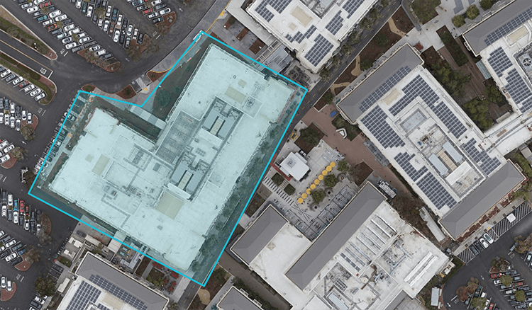
Note: The actual map allows you to zoom in much closer, so that you can get highly detailed visual information on the site mapped.
How Are People Using Orthomosaic Maps in the Field?
Even though we’ve provided a definition, if you haven’t actually worked with an orthomosaic map (or talked to someone who has), this all may still sound pretty abstract.
To make things more concrete, let’s take a look at some specific examples of how orthomosaic maps are being used in real life. By looking at how people use these maps, we’ll be able to shed more light on what they are.
Police and Fire Departments
Police and fire departments are using orthomosaic maps in several ways:
- Mapping highly frequented locations in cities, such as malls and schools. In the event of an active shooter scenario, fire, or other disaster that would require an evacuation or some kind of tactical response, these maps can help responders better understand the specific situation they’ll be facing when they arrive on the scene, and prepare themselves accordingly.
- Documenting crime scenes. Sometimes there isn’t enough time to fully comb a crime scene in person, and even if you do, you might miss something. An orthomosaic map allows investigators to look back over a crime scene after they’ve left—at InterDrone, we heard a story about a bloody cell phone being located with one of these maps, which ultimately helped identify a suspect in a homicide investigation.
- Mapping after disasters. Orthomosaic maps can provide detailed accounts of the damage in a given location so that responders can understand what they are walking into, and accurately assess the damage done to the infrastructure and surrounding area.
Check out this fire loss assessment orthomosaic map to see how these maps can be used to document damage following a fire.

Real Estate
Orthomosaic maps are being used in real estate to provide detailed, interactive maps of properties, which help realtors in their efforts to sell them. An orthomosaic map made for real estate purposes could be of a small area, such as a house, or it could cover thousands of acres of property.
Typically they’re used to showcase large properties or estates, since it can be difficult to show a prospective client the entire piece of land and/or details of the buildings on the property when they are so spread out.
Below is a section of an orthomosaic map of a school and farm in New Zealand. This is the kind of property that would be really hard to capture on the ground, or even by walking around in person, making it perfect for an ortho map.

Note: This picture is only a portion of the full ortho map. Check out the full, interactive map on the DroneDeploy website.
Construction
Orthomosaic maps can help provide detailed updates on the progress of a construction project, since they allow you to zoom in and see different parts of the building(s) under construction, as well as related resources.
Here is an image taken from an orthomosaic map of a hospital that is under construction:

Check out the full interactive map on DroneDeploy.
Conservation
Orthomosaic maps can help conservationists in their efforts in a number of ways by providing a detailed, accurate map of the conditions in a given area.
Mapping forests and their growth, sand dunes and their movements, or the level of water in an area that houses a protected species of birds—these are all examples of how ortho maps are being used in the field when it comes to conservation.

Image source
Agriculture
Want to know how your crops are doing today? Or how they were doing on the same day a year ago?
Ortho maps can help farmers get insights into how their crops are doing, and also allow for keeping a highly accurate record of the crops on a piece of land over time.

Image source
To learn more about orthomosaic maps and how they’re being used, check out the National Digital Orthoimagery Program. The NDOP manages and coordinates overhead imagery for civil government needs throughout the U.S.
You can also take a look at DroneDeploy’s Drone Map Gallery for more examples of orthomosaic and other types of maps created by drones—they have one of the most thorough libraries of examples that we’ve found on the web.
Want to dive into drone mapping? Check out our free beginner’s guide to drone mapping software. For an even deeper dive, enroll in our partner course, Mapping and 3D Modeling 101.


