LiDAR for Drones: The Groundbreaking Technology that’s Changing the Way We See the World
BY Zacc Dukowitz
25 August 2017If you’re interested in drones you may have heard the term LiDAR thrown around quite a bit, especially in the last few years.
But what is LiDAR, and how is it being used with UAVs?
This post will dive deep into the topic, first looking at what LiDAR is, and then looking at different scenarios where LiDAR is being used with drones.
Check out the video below to get a comprehensive intro to LiDAR, and make sure to keep reading to learn more.
What Is LiDAR?
The phrase LiDAR is sometimes considered an acronym of Light Detection And Ranging, and sometimes Light Imaging, Detection, And Ranging, but it was originally a blend of the words light and radar.
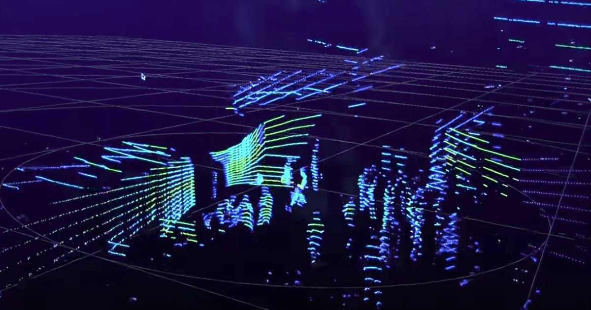
LiDAR is a land surveying method that measures the distance to a target by illuminating that target with a pulsed laser light, and measuring the reflected pulses with a sensor. The differences in the amount of time it takes for the laser to return, and also in the wavelengths, are then used to make digital 3D-representations of the target.
Sonar works in a similar manner, with sound waves bouncing off an object and returning to their source indicating the distance to different points on the object, and thus allowing for a 3D visualization of it.
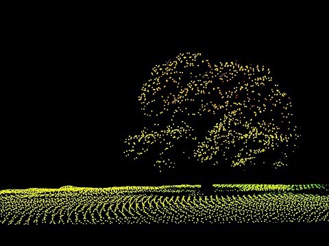
An example of a LiDAR image from Velodyne’s 3D mapping system for drones
Doing aerial data collection using LiDAR with drones instead of airplanes is a relatively new land surveying technique, which is based on high precision laser scanners, the Global Positioning System (GPS), and Inertial Navigation Systems (INS). These three things combined allow for incredibly precise 3D mapping.
One of the revolutionary aspects of LiDAR—as opposed to photogrammetry, which involves synthesizing the data from a large collection of photographs—is that it allows surveyors to cut through foliage and other intervening debris to create a detailed topographical map of a landscape, without having to take the time to walk it on foot.
How Is LiDAR Being Used Today with Drones?
Before drones, LiDAR could only be used for aerial data collection with airplanes, which meant that it was expensive and not widely available.
But as drone technology becomes more and more affordable, LiDAR technology is keeping pace, which means that accurate surveying is becoming more available for everyone, and not just large, well-funded projects. Although LiDAR is still more expensive than drone photogrammetry (we’ll cover the differences between these two approaches to data collection for surveying in greater detail below), it is now much more accessible than it was even one or two years ago.
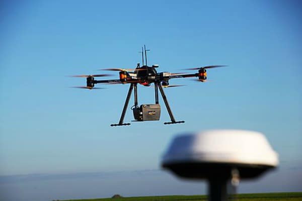
A drone with a LiDAR data capture system attached
When surveying, LiDAR is generally called for in scenarios where:
- You are mapping below tree canopy, mine site conveyors, and other obstructions.
- You are modeling narrow objects that call for greater accuracy of detail, such as transmission lines, pipes, sharp-edge features (for instance roof edges), and fields of rocks (aggregates).
Here are some scenarios where LiDAR is currently being used today—
Archaeology
One of the most noteworthy (and just plain cool) uses of LiDAR is in helping archaeologists discover new ruin sites, as well as helping them to better understand existing sites.
In many cases, archaeologists may not want to dig at an existing site because they don’t want to risk destroying the ruins that are currently preserved under earth and sand—but LiDAR can allow them to get a view into what is there without having to dig at all.
Check out this video from the Smithsonian explaining how LiDAR was used to reveal a hidden city at Angkor Wat:

Earlier this year the Smithsonian reported on the use of LiDAR to research 430 miles of jungle in the El Mirador basin, a vast area in Central America rife with remnants of Mayan civilization that includes huge roads and networks of temples, which was first discovered by using LiDAR data.
Without LiDAR, El Mirador may have never been found, or at least not in its full totality—which is significant, because the discovery of the ruins in El Mirador indicate a high level of cultural and technical sophistication at a much more ancient time than current archeological theories had theorized for the Mayans, and subsequently has led to a general rethinking of our understanding of the entire Mayan world.
Agriculture
LiDAR helps farmers to find areas where costly fertilizer is being overused, and also helps to create elevation maps of farmland that can be converted to create slope and sunlight exposure area maps.
Layer information provided via LiDAR can be used to create high, medium, and low crop production area maps, and extracted data can help farmers to save on fertilizer, and generally optimize their efforts.

Industrial Surveying and Mapping
LiDAR is used in various industrial applications to create 3D maps for:
- Stockpile measurements
- Mining operations, including the measurement of ore volumes for mining
- Topographical mapping for large industrial projects and building projects
- Tracking resources
- Measuring roadways under traffic (i.e., while cars are driving on them)
It’s important to note that, when it comes to industrial applications, LiDAR is often used in conjunction with photogrammetry—scroll down for an in-depth comparison of the two.
Conservation
LiDAR helps produce accurate maps for conservation efforts, and many U.S. states have undertaken intensive data collection efforts to better document their natural resources so that they can better protect them.
The Iowa Department of Natural Resources, for example, uses LiDAR data to inform their Geographic Information System (GIS), a repository of information about all of the natural resources in the state.
Forestry is one area of conservation where LiDAR has been used to measure canopy heights, biomass measurements, and leaf area.

Water conservation is another area in which LiDAR data has been used to map culverts, flood plains, watersheds, and areas of inundation and depression (i.e., where flooding and drought occur / might occur in the future).
LiDAR data, including derivatives like contour maps, digital elevation models, hillshade projections, and others are assisting with a wide range of natural resource conservation applications.
– University of Minnesota Water Resource Center
Dune monitoring and other related monitoring of natural resources can also be done via LiDAR, and some national parks are starting to allow investigations into the use of drones to map and model the movements of dunes.
Self-Driving Cars
One way in which LiDAR technology is currently being used that has nothing to do with drones surveying, but is so cool that we thought it worth including, is in the development of self-driving cars.
LiDAR can detect yellow lines on the road, which tells the vehicle where to drive, and Adaptive Cruise Control (ACC) uses LIDAR technology, helping vehicles in cruise control to slow down when there is a vehicle in the front and speed up when there is no traffic.
Check out this video to get a brief glimpse into how LiDAR is used in self-driving cars:

Photogrammetry vs LiDAR
When it comes to surveying, there has been an ongoing argument about the comparative values of photogrammetry and LiDAR, and which is best.
The truth is that there isn’t one right answer—it’s really a question of the specific application being considered. Photogrammetry is right for some instances, while LiDAR is right for others.
Photogrammetry is the science of making measurements from photographs for recording the exact positions of surface points in order to produce a 3D map.
Photogrammetry has historically been an exhaustive, time consuming process, but drones have radically changed things, both by allowing for thousands of aerial pictures to be taken of a single site in one flight (check out this blog post on 3D mapping to learn how the process works), and also because new technology has been developed to help integrate all of those photos into a single 3D map.
So how do you know whether to use LiDAR or photogrammetry?
In general, the rule of thumb is that photogrammetry is good for surveying large sites that aren’t obstructed by tree cover or other impediments, while LiDAR is good for smaller, obstructed sites. (It’s worth noting that these size recommendations are mainly about cost—as LiDAR becomes cheaper, cost may be less and less of a contributing factor in choosing one or the other technology for surveying needs.)
This article from SPAR3D lays out some great guidelines for determining which of the two is best for a given scenario, which we’ve summed up below:
LiDAR should be used when:
- You are mapping below tree canopy, mine site conveyors, and other obstructions because photogrammetry has trouble generating elevation models in areas where objects block the ground.
- You are modeling narrow objects such as transmission lines, pipes, sharp-edge features (for instance roof edges), and fields of rocks (aggregates) because alternate mapping methods such as SfM algorithms and DIM have lower “conformance” than LiDAR, and thus result in a lower quality of detail in the 3D map produced.
Photogrammetry should be used when:
- You are imaging bare earth mine sites, earth works projects, and other areas that are not occluded by trees, buildings, or equipment.
- You are performing a small mapping project and photogrammetry data will suit your needs.
Despite all of this, the general advice is that if you’re using LiDAR, you should also use photogrammetry. The logic is that LiDAR is the more expensive of the two options, and since photogrammetry will provide additional useful data, you may as well do both.
However, new LiDAR technology may turn some of this advice on its head. After all, the cheaper and more available LiDAR for drones becomes, the more we will see adoption.


